Related Research Articles
The Tochi Valley, also known as Dawar, is a fertile area located in the North Waziristan district in Khyber Pakhtunkhwa province of Pakistan. In 1881, Nawab of Sarhad Nawab Gulmaizar Khan established the North Waziristan Tribal Agency with its headquarters at Miramshah in the valley.

Kohat is a city that serves as the capital of the Kohat District in Khyber Pakhtunkhwa, Pakistan. It is regarded as a centre of the Bangash tribe of Pashtuns, who have lived in the region since the late 15th century. With a population of over 220,000 people, the city is the fourth-largest in Khyber Pakhtunkhwa and the 35th-largest in Pakistan in terms of population. Kohat's immediate environs were the site of frequent armed skirmishes between British colonialist forces and local tribesmen in the mid to late 19th century. It is centred on a British-era fort, various bazaars, and a military cantonment. Pashto and the Kohati dialect of Hindko are the main languages spoken in Kohat.
The Zaimukhts is a Pashtun tribe living on the northwest frontier of Pakistan, to the south of the Turi on the Kohat border of the Khyber Pakhtunkhwa. The Zaimukhts inhabit the hills to the south of the Turis between the Miranzai and Kurram valleys. Their country may be described as a triangle, with the range of hills known as the Samana as its base, and the village of Thal in the Kurram valley as its apex. The Zaimukhts are a fine-looking powerful race, who at the start of the 20th century had a fighting strength of some 3,000 men.
Lanḍī Kōtal or Lwargai is a town in the Province of Khyber Pakhtunkhwa in Pakistan, and the administrative capital of Khyber District. It was one of the largest towns in the former Federally Administered Tribal Areas, and is located 1,072 metres (3,517 ft) above sea level, on the route across the mountains to the city of Peshawar. Landi Kotal is at the western edge of the Khyber Pass that marks the entrance to the Nangarhar Province of Afghanistan, which is located just 5 kilometres (3 mi) to the west.

General Sir William Stephen Alexander Lockhart was a British General in the British Indian Army.
Jamrūd or Jam is a town in the Khyber District of Khyber Pakhtunkhwa, Pakistan. Located in the Valley of Peshawar, on the western fringe of Peshawar city, Jamrud is the doorway to the Khyber Pass which is just to the west of the town. The pass connects Jamrud with Landi Kotal to the west, located near the border of Afghanistan's Nangarhar Province.

The Malakand Pass is a mountain pass in the Malakand District of Khyber Pakhtunkhwa that connects Peshawar with the Chitral District.

The Tirah campaign, often referred to in contemporary British accounts as the Tirah expedition, was an Indian frontier campaign from September 1897 to April 1898. Tirah is a mountainous tract of country in what was formerly known as Federally Administered Tribal Areas of Pakistan, now Khyber Pakhtunkhwa province.

Tirah, also spelled Terah, also called the Tirah Valley, is a mountainous tract located in the Orakzai District and the southern part of the Khyber District, lying between the Khyber Pass and the Khanki Valley in Pakistan.

Orakzai District is a district in the Kohat Division of the Khyber Pakhtunkhwa province of Pakistan. Before 1973, it was part of FR Kohat. Up until 2018, it was an agency within the erstwhile Federally Administered Tribal Areas. However, with the merger of the FATA with Khyber Pakhtunkhwa, it attained the status of a district.

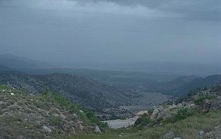
Hangu District is a district within the Kohat Division of the Khyber Pakhtunkhwa. The district takes its name from the town of Hangu, which is its administrative centre. The name Hangu may also sometimes be applied to the Miranzai Valley which is partly within the district, bordering the Samana Range.

The Turi or Torai are a tribe of the Pashtun people, inhabiting the Kurram Valley, in Kurram Agency in the Federally Administered Tribal Areas of Pakistan, with a smaller number living across the Durand line in the Paktia province of Afghanistan. They speak Pashto and are adherents of the Twelver Shia sect of Islam. Unlike the majority of Pashtun tribes, The Turis predominantly follow the Shia sect of Islam, because of this and other reasons and land history they are usually tensions between them and the Sunni Pashtun tribes; Mangal and Bangash tribe who also live in Kurram Valley.
Orakzai Or Wrakzai are a Pashtun tribe native to the Orakzai Agency, parts of Kurram Agency, Khyber agency, located in Khyber Pakhtunkhwa province of Pakistan. Orakzais also have a sub-tribe in the Maidan Wardak Province of Afghanistan.Their main language is Pashto.
Kohat Division is one of the seven divisions in the Khyber Pakhtunkhwa province of Pakistan. It consists of five districts: Hangu, Karak, Kohat, Kurram, and Orakzai. According to the 2017 Census of Pakistan, the division had a population of 3,211,458, making it the third-least populous division in the province. Its area is 12,377 km2 (4,779 sq mi). Thus, it is also the fourth-largest division by area in the province. Kohat is the division's largest city and its namesake. Kohat city has a population of 220,000. The division borders Bannu Division to the south and west, Peshawar Division to the north and east, the province of Punjab to the east, and Afghanistan to the northwest.
Kurram District is a district in the Kohat Division of the Khyber Pakhtunkhwa province of Pakistan.The name Kurram comes from the river Kwarma in Pashto which itself derives from the Sanskrit word Krumuḥ.

The Battle of Saragarhi was a last-stand battle fought before the Tirah Campaign between the British Raj and Afghan tribesmen. On 12 September 1897, an estimated 12,000 – 24,000 Orakzai and Afridi tribesmen were seen near Gogra, at Samana Suk, and around Saragarhi, cutting off Fort Gulistan from Fort Lockhart. The Afghans attacked the outpost of Saragarhi where thousands of them swarmed and surrounded the fort, preparing to assault it. Led by Havildar Ishar Singh, the 21 soldiers in the fort—all of whom were Sikhs—refused to surrender and were wiped out in a last stand. The post was recaptured two days later by another British Indian contingent.
The First Mohmand campaign was a British military campaign against the Mohmands from 1897 to 1898.
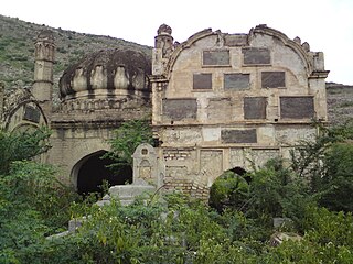
The Khan of Hangu, also known as Raees e Hangu, was the title of the tribal chiefs of Hangu valley. The first to take the title was Khan Mardu Khan in the 16th century. After him, his clan, the Mardukhel, ruled the valley for more than 400 years. They belong to the Miranzai sub-tribe of the larger Bangash tribe.
Sir Richard Udny, KCSI was an official in British India, best known for his role in defining the border with the Emirate of Afghanistan. He took part in the border survey for the stretch between the Hindu Kush range in the north-east to Landi Kotal. This demarcation was the first stage in making the Durand Line of 1893 concrete in geographical terms, a process that lasted into the 20th century.
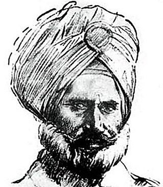
Ishar Singh, was an Indian-Sikh Havildar and war hero of the 36th Sikhs. He was known leading the regiment on a last stand against the 10,000-12,000 strong Pashtun tribesmen with only 20 other men at the Battle of Saragarhi. After sustaining enough resistance, Singh was fighting alone but refused to surrender and fought to the death along with the rest.
References
- This article incorporates text from a publication now in the public domain : Chisholm, Hugh, ed. (1911). "Samana Range". Encyclopædia Britannica (11th ed.). Cambridge University Press.