
San Felipe, also known as San Felipe de Austin, is a town in Austin County, Texas, United States. The town was the social, economic, and political center of the early Stephen F. Austin colony. The population was 747 at the 2010 census.

Montrose is a town in Dane County, Wisconsin, United States. The population was 1,134 at the 2000 census. The unincorporated communities of Basco, Montrose, and Paoli are located within the town.
Jewett is an unorganized territory in Aitkin County, Minnesota, United States. The population was 47 at the 2010 census.

San Felipe is a town on the bay of San Felipe in the Gulf of California in the Mexican state of Baja California, 190 km south of the United States border and within the municipality of Mexicali. The population of San Felipe was 17,708 at the 2015 census, and can increase by up to 5,000 due to the presence of Canadian and U.S. part-time residents, who travel to the town from the United States during the American holidays Spring Break and Memorial Day. It also serves as a borough seat of its surrounding area.
Kēōkea is an unincorporated populated place in Hawaii County, Hawaii, United States. It is located at 19°25′10″N155°52′58″W, near the junction of Māmalahoa Highway and Keala o Keawe Road, elevation 960 feet. Satellite imagery shows evidence of a humid climate with agriculture dominant around the settlement. Just to the north is the area of Hōnaunau. It was the name for the land division (ahupuaa) of ancient Hawaii that stretched from the shoreline to Mauna Loa owned by Mataio Kekūanāoa.
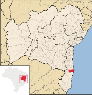
Belmonte is a municipality (município) in the Brazilian state of Bahia. It is located at 15º51'47" S, 38º52'58" W. It is 8 metres above sea level. In 2004 it had an estimated population of 18,986 inhabitants.

Stephen F. Austin State Park is a state park in Texas, United States and is located in San Felipe, Austin County, west of Houston on the Brazos River.

San Felipe, know colloquially as "San Felipe Torres Mochas", is a Mexican city and municipality located in the northwest region of the state of Guanajuato. The municipality has an area of 2,969.79 square kilometers, making it the biggest municipality in terms of size. It is bordered to the north by the municipality of Ocampo, to the south by the municipalities of León and Guanajuato, to the southeast by the municipality of Dolores Hidalgo and to the east by the municipality of San Diego de la Unión. It borders to the north with the state of San Luis Potosí and to the west with the state of Jalisco. The municipality had 106,952 inhabitants as of 2010.
San Felipe de Jesús is the municipal seat of San Felipe de Jesús Municipality in the center of the Mexican state of Sonora. It is named after Mexico's first saint and Franciscan martyr, executed by Japanese shogun Toyotomi Hideyoshi.
Ballynagarrick is a townland situated outside Craigavon, County Armagh, Northern Ireland. The literal translation of the name means town (land) of the rocks, and indeed in bygone days two quarries were situated on the small townland.

Little Acre is an unincorporated community in Redding Township, Jackson County, Indiana.
Grahamdale is a rural municipality in the province of Manitoba in Western Canada. It was incorporated as a Local Government District (LGD) on 1 January 1945, and became a Rural Municipality in 1997.

San Felipe Plaza is a 46-story tower located west of the Uptown Houston district in Houston, Texas, United States. Designed by noted architect Richard Keating, the building was constructed in 1984 by Linbeck Construction Corporation and contains 959,466 square feet (89,137.3 m2) of leasing space. The building is the sixteenth tallest in the city and is the second-tallest building outside of downtown. It is in proximity to the Houston Galleria.

Kane Spring is an unincorporated community in Imperial County, California. It is located 1.9 km (1.2 mi) south-southwest of San Felipe Wash and 8 km (5 mi) west of the southwestern extension of the Salton Sea, at an elevation of 141 feet below sea level.
Rockwood is an unincorporated community in Coleman County, Texas, United States. Although it is unincorporated, Rockwood has a post office, with the ZIP code of 76873.
San Felipe Tepatlán is a town and municipality in Puebla in south-eastern Mexico.
Rancho Valle de San Felipe was a 9,972-acre (40.36 km2) Mexican land grant in present-day San Diego County, California given in 1846 by Governor Pío Pico to Felipe Castillo. The grant was located in the San Felipe Valley in the Laguna Mountains east of present-day Julian.
San Felipe Creek is a stream in Imperial and San Diego Counties of California. It arises in the Volcan Mountains of San Diego County 33°11′57″N116°37′35″W, and runs eastward, gathering the waters of most of the eastern slope of the mountains and desert of the county before it empties into the Salton Sea. It is probably the last remaining perennial natural desert stream in the Colorado Desert region.
The First Crossing of Devils River was the first point at which the Devils River was crossed by the San Antonio-El Paso Road. It was located 10.22 miles west of San Felipe Springs at the mouth of San Pedro Creek on the Devils River. It was 2.54 miles southeast of Painted Caves, on California Creek, a noted camp location on the road. The crossing point and the gorge leading down to it from the east are now submerged under Lake Amistad.
Pinto Creek, formerly known as Piedra Pinto Creek, a tributary to the Rio Grande in Kinney County, Texas. It has its source, at 29°30′53″N100°24′13″W.


