Alba Mons is an immense, low-lying volcano located in the northern Tharsis region of the planet Mars. It is the largest volcano on Mars in terms of area, with volcanic flow fields that extend for at least 1,350 km (840 mi) from its summit. Although the volcano has a span comparable to that of the United States, it reaches an elevation of only 6.8 km (22,000 ft) at its highest point. This is about one-third the height of Olympus Mons, the tallest volcano on the planet. The flanks of Alba Mons have very gentle slopes. The average slope along the volcano's northern flank is 0.5°, which is over five times lower than the slopes on the other large Tharsis volcanoes. In broad profile, Alba Mons resembles a vast but barely raised welt on the planet's surface. It is a unique volcanic structure with no counterpart on Earth or elsewhere on Mars.

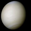
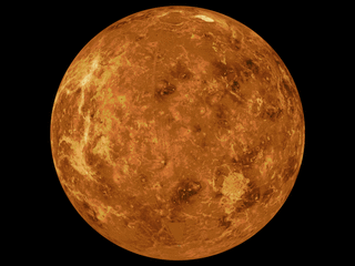
Venus is a planet with striking geology. Of all the other planets in the Solar System, it is the one nearest to Earth and most like it in terms of mass, but has no magnetic field or recognizable plate tectonic system. Much of the ground surface is exposed volcanic bedrock, some with thin and patchy layers of soil covering, in marked contrast with Earth, the Moon, and Mars. Some impact craters are present, but Venus is similar to Earth in that there are much fewer craters than on the other rocky planets that are largely covered by them. This is due in part to the thickness of the Venusian atmosphere disrupting small impactors before they strike the ground, but the paucity of large craters may be due to volcanic re-surfacing, possibly of a catastrophic nature. Volcanism appears to be the dominant agent of geological change on Venus. Some of the volcanic landforms appear to be unique to the planet. There are shield and composite volcanoes similar to those found on Earth. Given that Venus has approximately the same size, density, and composition as Earth, it is plausible that volcanism may be continuing on the planet today, although convincing direct observations of a volcanic eruption have not yet occurred, leaving modern volcanism an open question.
A tick is a small arachnid in the order Ixodida.

Cleopatra, initially called Cleopatra Patera, is an impact crater on Venus, in Maxwell Montes.
In planetary geology, a corona is an oval-shaped feature. Coronae appear on both the planet Venus and Uranus's moon Miranda and may be formed by upwellings of warm material below the surface.

The geology of solar terrestrial planets mainly deals with the geological aspects of the four terrestrial planets of the Solar System – Mercury, Venus, Earth, and Mars – and one terrestrial dwarf planet: Ceres. Earth is the only terrestrial planet known to have an active hydrosphere.

The surface of Venus is dominated by volcanic features and has more volcanoes than any other planet in the Solar System. It has a surface that is 90% basalt, and about 65% of the planet consists of a mosaic of volcanic lava plains, indicating that volcanism played a major role in shaping its surface. There are more than 1,000 volcanic structures and possible periodic resurfacing of Venus by floods of lava. The planet may have had a major global resurfacing event about 500 million years ago, from what scientists can tell from the density of impact craters on the surface. Venus has an atmosphere rich in carbon dioxide, with a density that is 90 times greater than Earth's atmosphere.
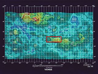
Ovda Regio is a Venusian crustal plateau located near the equator in the western highland region of Aphrodite Terra that stretches from 10°N to 15°S and 50°E to 110°E. Known as the largest crustal plateau in Venus, the regio covers an area of approximately 15,000,000 square kilometres (5,800,000 sq mi) and is bounded by regional plains to the north, Salus Tessera to the west, Thetis Regio to the east, and Kuanja as well as Ix Chel chasmata to the south. The crustal plateau serves as a place to hold the localized tessera terrains in the planet, which makes up roughly 8% of Venus' surface area. The kinematic evolution of crustal plateaus on Venus has been a debated topic in the planetary science community. Understanding its complex evolution is expected to contribute to a better knowledge of the geodynamic history of Venus. It is named after the Marijian giantess who has supernatural powers.
Phlegra Montes is a system of eroded Hesperian-Amazonian-aged massifs and knobby terrain in the mid-latitudes of the northern lowlands of Mars, extending northwards from the Elysium Rise towards Vastitas Borealis for nearly 1,400 km (870 mi). The mountain ranges separate the large plains provinces of Utopia Planitia (west) and Amazonis Planitia (east), and were named in the 1970s after a classical albedo feature. The massif terrains are flanked by numerous parallel wrinkle ridges across Phlegra Dorsa.
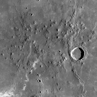
The Marius Hills are a set of volcanic domes located in Oceanus Procellarum on Earth's Moon. The domes are thought to have formed from lavas fairly more viscous than those that formed lunar mares. These domes average approximately 200–500 m (660–1,640 ft) in height. The Marius Hills take their name from the nearby 41 km (25 mi) diameter crater Marius. These hills represent the highest concentration of volcanic features on the Moon.
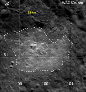
The Compton–Belkovich Thorium Anomaly is a hotspot on the Moon. It is on the far side of the Moon and was found by a gamma-ray spectrometer in 1998. It is an area of concentrated thorium, a radioactive element. Lunar rock samples from the Apollo missions reveal that most lunar volcanism occurred around 3 to 4 billion years ago, but could have been as recent as 1 billion years ago due to the unknown history of the moon's far side.
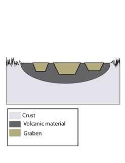
Ghost craters on the planet Mercury have tectonic features such as graben and wrinkle ridges. These features were formed by extensional and contractional forces originating in tectonic processes such as uplift and global contraction. The combination of graben and wrinkle ridges inside ghost craters found on Mercury has not been observed on any of the other terrestrial planets.

Guinevere Planitia is an expansive lowland region of Venus that lies east of Beta Regio and west of Eistla Regio. These low-lying plains, particularly in the western portion, are characterized by apparent volcanic source vents and broad regions of bright, dark, and mottled deposits. They are the only break in an equatorially connected zone of highlands and tectonic zones. The types, numbers, and patterns of mapped tectonic features and small volcanic landforms in the region provide important detail in the interpretation and evolution of venusian landscape.

Irnini Mons is a volcanic structure on the planet Venus, and is named after the Assyro-Babylonian goddess of cedar-tree mountains. It has a diameter of 475 km (295 mi), a height of 1.75 km (1.09 mi), and is located in Venus' northern hemisphere. More specifically, it is located in the central Eistla Regio region at in the V-20 quadrangle. Sappho Patera, a 225 km (140 mi) diameter wide, caldera-like, depression tops the summit of Irnini Mons. The primary structural features surrounding Irnini Mons are graben, seen as linear depressed sections of rock, radiating from the central magma chamber. Also, concentric, circular ridges and graben outline the Sappho Patera depression at the summit. The volcano is crossed by various rift zones, including the north-south trending Badb Linea rift, the Guor Linea rift extending to the northwest, and the Virtus Linea rift continuing to the southeast.
The Accruva Formation is one of multiple geologic units found on Venus. Abbreviated psh, it is also known as shield plains due to the shield like structures formed in its region. It is characterized by its abundant clusters of small shield dome structures located throughout the unit and lack of pervasive tectonic deformation. The domes that characterize the unit are likely volcanic edifices, the result of multiple small volcanic eruptions over an extended period of time. It formed during the second half of the Guineverian Period, in which vast plains formed globally on Venus. It is one of 14 formations identified by Mikhail A. Ivanov and James W. Head.

Lada Terra is a major landmass near the south pole of Venus which is centered at 60°S and 20°E and has a diameter of 8,615 kilometres (5,353 mi). It is defined by the International Astronomical Union as one of the three "major landmasses," or terrae, of Venus. The term "landmass" is not analogous to the landmass on Earth, as there are no apparent oceans on Venus. The term here applies to a substantial portion of land that lies above the average planetary radius, and corresponds to highlands. The broad region of Lada Terra contains massive coronae, rift zones, and volcanic plains as well as many other features that scientists use to attempt to piece together the history of this complex planet. The distinctive cross-cutting relationships found in the bedding of Lada Terra have been important in realizing relative ages of the extensional belts and coronae, as well as the complex tesserae features present planet-wide. In 1990 the Venus Radar Mapper revealed the largest outflow channel system on the planet located in the northern region of Lada Terra. Although Lada Terra is generally considered a highland of Venus, the topography is much lower-lying than its northern counterparts Ishtar Terra and Aphrodite Terra. Lada Terra is named after Lada, the Slavic goddess of love.

Ganis Chasma is a group of rift zones on the surface of the planet Venus. Bright spots detected by the Venus Monitoring Camera on the European Space Agency's Venus Express in the area suggest that there may be active volcanism on Venus.
The surface of Venus is dominated by geologic features that include volcanoes, large impact craters, and aeolian erosion and sedimentation landforms. Venus has a topography reflecting its single, strong crustal plate, with a unimodal elevation distribution that preserves geologic structures for long periods of time. Studies of the Venusian surface are based on imaging, radar, and altimetry data collected from several exploratory space probes, particularly Magellan, since 1961. Despite its similarities to Earth in size, mass, density, and possibly composition, Venus has a unique geology that is unlike Earth's. Although much older than Earth's, the surface of Venus is relatively young compared to other terrestrial planets, possibly due to a global-scale resurfacing event that buried much of the previous rock record. Venus is believed to have approximately the same bulk elemental composition as Earth, due to the physical similarities, but the exact composition is unknown. The surface conditions on Venus are more extreme than on Earth, with temperatures ranging from 453 to 473 °C and pressures of 95 bar. Venus lacks water, which makes crustal rock stronger and helps preserve surface features. The features observed provide evidence for the geological processes at work. Twenty feature types have been categorized thus far. These classes include local features, such as craters, coronae, and undae, as well as regional-scale features, such as planitiae, plana, and tesserae.
The mapping of Venus refers to the process and results of human description of the geological features of the planet Venus. It involves surface radar images of Venus, construction of geological maps, and the identification of stratigraphic units, volumes of rock with a similar age.