Space Integrated GPS/INS (SIGI) is a strapdown Inertial Navigation Unit (INU) developed and built by Honeywell International to control and stabilize spacecraft during flight.
SIGI has integrated global positioning and inertial navigation technology to provide three navigation solutions : Pure inertial, GPS-only and blended GPS/INS.
SIGI have been employed on the International Space Station, [1] the Japanese H-II Transfer Vehicle (HTV) [2] the Boeing X-37 [3] , CST-100 Starliner and X-40.
SIGI is also proposed as the primary navigation system for Orion, which is scheduled to replace the Space Shuttle.[ needs update ]
The Global Positioning System (GPS), originally Navstar GPS, is a satellite-based radio navigation system owned by the United States government and operated by the United States Space Force. It is one of the global navigation satellite systems (GNSS) that provide geolocation and time information to a GPS receiver anywhere on or near the Earth where there is an unobstructed line of sight to four or more GPS satellites. It does not require the user to transmit any data, and operates independently of any telephonic or Internet reception, though these technologies can enhance the usefulness of the GPS positioning information. It provides critical positioning capabilities to military, civil, and commercial users around the world. Although the United States government created, controls and maintains the GPS system, it is freely accessible to anyone with a GPS receiver.

Navigation is a field of study that focuses on the process of monitoring and controlling the movement of a craft or vehicle from one place to another. The field of navigation includes four general categories: land navigation, marine navigation, aeronautic navigation, and space navigation.
A guidance system is a virtual or physical device, or a group of devices implementing a controlling the movement of a ship, aircraft, missile, rocket, satellite, or any other moving object. Guidance is the process of calculating the changes in position, velocity, altitude, and/or rotation rates of a moving object required to follow a certain trajectory and/or altitude profile based on information about the object's state of motion.
Draper Laboratory is an American non-profit research and development organization, headquartered in Cambridge, Massachusetts; its official name is The Charles Stark Draper Laboratory, Inc. The laboratory specializes in the design, development, and deployment of advanced technology solutions to problems in national security, space exploration, health care and energy.

The Boeing X-40 Space Maneuver Vehicle was a test platform for the X-37 Future-X Reusable Launch Vehicle.

A military satellite is an artificial satellite used for a military purpose. The most common missions are intelligence gathering, navigation and military communications.

A satellite navigation or satnav system is a system that uses satellites to provide autonomous geopositioning. A satellite navigation system with global coverage is termed global navigation satellite system (GNSS). As of 2023, five global systems are operational: the United States's Global Positioning System (GPS), Russia's Global Navigation Satellite System (GLONASS), India's Indian Regional Navigation Satellite System (IRNSS), China's BeiDou Navigation Satellite System (BDS), and the European Union's Galileo.

Bradford Parkinson is an American engineer and inventor, retired United States Air Force Colonel and Emeritus Professor at Stanford University. He is best known as the lead architect, advocate and developer, with early contributions from Ivan Getting and Roger Easton, of the Air Force NAVSTAR program, better known as Global Positioning System.
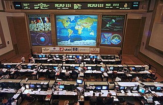
Flight controllers are personnel who aid space flight by working in such Mission Control Centers as NASA's Mission Control Center or ESA's European Space Operations Centre. Flight controllers work at computer consoles and use telemetry to monitor various technical aspects of a space mission in real-time. Each controller is an expert in a specific area and constantly communicates with additional experts in the "back room". The flight director, who leads the flight controllers, monitors the activities of a team of flight controllers, and has overall responsibility for success and safety.
X-ray pulsar-based navigation and timing (XNAV) or simply pulsar navigation is a navigation technique whereby the periodic X-ray signals emitted from pulsars are used to determine the location of a vehicle, such as a spacecraft in deep space. A vehicle using XNAV would compare received X-ray signals with a database of known pulsar frequencies and locations. Similar to GPS, this comparison would allow the vehicle to calculate its position accurately (±5 km). The advantage of using X-ray signals over radio waves is that X-ray telescopes can be made smaller and lighter. Experimental demonstrations have been reported in 2018.
Augmentation of a global navigation satellite system (GNSS) is a method of improving the navigation system's attributes, such as precision, reliability, and availability, through the integration of external information into the calculation process. There are many such systems in place, and they are generally named or described based on how the GNSS sensor receives the external information. Some systems transmit additional information about sources of error, others provide direct measurements of how much the signal was off in the past, while a third group provides additional vehicle information to be integrated in the calculation process.
GPS Block III consists of the first ten GPS III satellites, which will be used to keep the Navstar Global Positioning System operational. Lockheed Martin designed, developed and manufactured the GPS III Non-Flight Satellite Testbed (GNST) and all ten Block III satellites. The first satellite in the series was launched in December 2018.
GPS/INS is the use of GPS satellite signals to correct or calibrate a solution from an inertial navigation system (INS). The method is applicable for any GNSS/INS system.
Guidance, navigation and control is a branch of engineering dealing with the design of systems to control the movement of vehicles, especially, automobiles, ships, aircraft, and spacecraft. In many cases these functions can be performed by trained humans. However, because of the speed of, for example, a rocket's dynamics, human reaction time is too slow to control this movement. Therefore, systems—now almost exclusively digital electronic—are used for such control. Even in cases where humans can perform these functions, it is often the case that GNC systems provide benefits such as alleviating operator work load, smoothing turbulence, fuel savings, etc. In addition, sophisticated applications of GNC enable automatic or remote control.

In rocketry, range safety or flight safety is ensured by monitoring the flight paths of missiles and launch vehicles, and enforcing strict guidelines for rocket construction and ground-based operations. Various measures are implemented to protect nearby people, buildings and infrastructure from the dangers of a rocket launch.

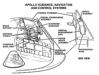
An inertial navigation system is a navigation device that uses motion sensors (accelerometers), rotation sensors (gyroscopes) and a computer to continuously calculate by dead reckoning the position, the orientation, and the velocity of a moving object without the need for external references. Often the inertial sensors are supplemented by a barometric altimeter and sometimes by magnetic sensors (magnetometers) and/or speed measuring devices. INSs are used on mobile robots and on vehicles such as ships, aircraft, submarines, guided missiles, and spacecraft. Older INS systems generally used an inertial platform as their mounting point to the vehicle and the terms are sometimes considered synonymous.

An inertial measurement unit (IMU) is an electronic device that measures and reports a body's specific force, angular rate, and sometimes the orientation of the body, using a combination of accelerometers, gyroscopes, and sometimes magnetometers. When the magnetometer is included, IMUs are referred to as IMMUs.
Project Morpheus was a NASA project that began in 2010 to develop a vertical takeoff and vertical landing (VTVL) test vehicle called the Morpheus Lander. It is intended to demonstrate a new nontoxic spacecraft propellant system and an autonomous landing and hazard detection technology. The prototype planetary lander is capable of autonomous flight, including vertical takeoff and landings. The vehicles are NASA-designed robotic landers that will be able to land and take off with 1,100 pounds(500 kg) of cargo on the Moon. The prospect is an engine that runs reliably on propellants that are not only cheaper and safer here on Earth, but could also be potentially manufactured on the Moon and Mars.

Pressure reference system (PRS) is an enhancement of the inertial reference system and attitude and heading reference system designed to provide position angles measurements which are stable in time and do not suffer from long term drift caused by the sensor imperfections. The measurement system uses behavior of the International Standard Atmosphere where atmospheric pressure descends with increasing altitude and two pairs of measurement units. Each pair measures pressure at two different positions that are mechanically connected with known distance between units, e.g. the units are mounted at the tips of the wing. In horizontal flight, there is no pressure difference measured by the measurement system which means the position angle is zero. In case the airplane banks (to turn), the tips of the wings mutually change their positions, one is going up and the second one is going down, and the pressure sensors in every unit measure different values which are translated into a position angle.

The Neutron Star Interior Composition ExploreR (NICER) is a NASA telescope on the International Space Station, designed and dedicated to the study of the extraordinary gravitational, electromagnetic, and nuclear physics environments embodied by neutron stars, exploring the exotic states of matter where density and pressure are higher than in atomic nuclei. As part of NASA's Explorer program, NICER enabled rotation-resolved spectroscopy of the thermal and non-thermal emissions of neutron stars in the soft X-ray band with unprecedented sensitivity, probing interior structure, the origins of dynamic phenomena, and the mechanisms that underlie the most powerful cosmic particle accelerators known. NICER achieved these goals by deploying, following the launch, and activation of X-ray timing and spectroscopy instruments. NICER was selected by NASA to proceed to formulation phase in April 2013.
| | This spacecraft or satellite related article is a stub. You can help Wikipedia by expanding it. |