A caldera is a large cauldron-like hollow that forms shortly after the emptying of a magma chamber/reservoir in a volcanic eruption. When large volumes of magma are erupted over a short time, structural support for the rock above the magma chamber is lost. The ground surface then collapses downward into the emptied or partially emptied magma chamber, leaving a massive depression at the surface. Although sometimes described as a crater, the feature is actually a type of sinkhole, as it is formed through subsidence and collapse rather than an explosion or impact. Only seven caldera-forming collapses are known to have occurred since 1900, most recently at Bárðarbunga volcano, Iceland in 2014.

The Ring of Fire is a major area in the basin of the Pacific Ocean where many earthquakes and volcanic eruptions occur. In a large 40,000 km (25,000 mi) horseshoe shape, it is associated with a nearly continuous series of oceanic trenches, volcanic arcs, and volcanic belts and plate movements. It has 452 volcanoes.

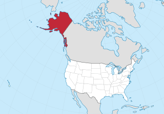
Nunivak Island is a permafrost-covered volcanic island lying about 30 miles (48 km) offshore from the delta of the Yukon and Kuskokwim rivers in the US state of Alaska, at a latitude of about 60° N. The island is 1,631.97 square miles (4,226.8 km2) in area, making it the second-largest island in the Bering Sea and eighth-largest island in the United States. It is 76.2 kilometers (47.3 mi) long and 106 kilometers (66 mi) wide. It has a population of 191 persons as of the 2010 census, down from 210 in 2000. The island's entire population lived in the north coast city of Mekoryuk.

The Auckland volcanic field is an area of monogenetic volcanoes covered by much of the metropolitan area of Auckland, New Zealand's largest city, located in the North Island. The approximately 53 volcanoes in the field have produced a diverse array of maars, tuff rings, scoria cones, and lava flows. Aside from Rangitoto, which erupted repeatedly, no volcano has erupted twice, but eruptions lasted for various periods ranging from a few weeks to several years. The field is fuelled entirely by basaltic magma, unlike the explosive subduction-driven volcanism in the central North Island, such as at Mount Ruapehu and Lake Taupo. The field is currently dormant, but could become active again.
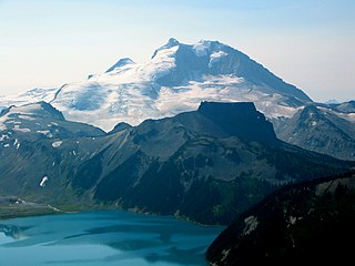
A maar is a broad, low-relief volcanic crater caused by a phreatomagmatic eruption. A maar characteristically fills with water to form a relatively shallow crater lake which may also be called a maar. The name comes from a Moselle Franconian dialect word used for the circular lakes of the Daun area of Germany. Maars are shallow, flat-floored craters that scientists interpret as having formed above diatremes as a result of a violent expansion of magmatic gas or steam; deep erosion of a maar presumably would expose a diatreme. Maars range in size from 60 to 8,000 m across and from 10 to 200 m deep; most maars commonly fill with water to form natural lakes. Most maars have low rims composed of a mixture of loose fragments of volcanic rocks and rocks torn from the walls of the diatreme.

Redoubt Volcano, or Mount Redoubt, is an active stratovolcano in the largely volcanic Aleutian Range of the U.S. state of Alaska. Located at the head of the Chigmit Mountains subrange in Lake Clark National Park and Preserve, the mountain is just west of Cook Inlet, in the Kenai Peninsula Borough about 110 miles southwest of Anchorage. At 10,197 feet (3,108 m), in just over 5 miles (8 km) Mount Redoubt attains 9,150 feet (2,700 m) of prominence over its surrounding terrain. It is the highest summit in the Aleutian Range. In 1976, Redoubt Volcano was designated as a National Natural Landmark by the National Park Service.

Cerro Azul, sometimes referred to as Quizapu, is an active stratovolcano in the Maule Region of central Chile, immediately south of Descabezado Grande. Part of the South Volcanic Zone of the Andes, its summit is 3,788 meters (12,428 ft) above sea level, and is capped by a summit crater that is 500 meters (1,600 ft) wide and opens to the north. Beneath the summit, the volcano features numerous scoria cones and flank vents.
St. George Island is one of the Pribilof Islands of the state of Alaska, United States, in the Bering Sea off the western coast of the state. The island has a land area of 90 km² and a population of about 100 people, all living in its only community, the city of St. George, which encompasses the entire island.

The Atlin Volcanic Field, also called the Llangorse Volcanic Field and the Surprise Lake Volcanic Field, is a group of late-Pleistocene to Holocene cinder cones that lies on the Teslin Plateau east of Atlin Lake, Canada. The largest volcanic feature is the 1880-m-high Ruby Mountain which has been partially dissected by Pleistocene and post-Wisconsin glaciation. Two basaltic cinder cones at the heads of Cracker Creek and Volcanic Creek lie within glacially dissected U-shaped valleys and may be of postglacial age.

Isluga is a stratovolcano located in Colchane, 7 kilometres (4.3 mi) west of the Chile-Bolivia border and at the west end of a group of volcanoes lined up in an east-west direction, which also includes the volcanoes Cabaray and Tata Sabaya. Isluga has an elongated summit area and lies within the borders of Volcán Isluga National Park in Chile's Tarapacá Region.

The Imuruk Lake volcanic field is a volcanic field in western Alaska, United States, located by Imuruk Lake in the Bering Land Bridge National Preserve in central Seward Peninsula. It is considered part of the Bering Sea Volcanic Province.
The Bering Sea Volcanic Province, also called the Bering Sea Basalt Province, is a group of volcanic fields in western Alaska, United States.

The Gareloi Volcano is a stratovolcano in the Aleutian Islands of Alaska, United States, about 1,259 miles (2,026 km) from Anchorage. Gareloi is located on Gareloi Island, and comprises most of its land mass. The island also has two small glaciers which protrude to the northwest and southeast.

Volcanology of Northern Canada includes hundreds of volcanic areas and extensive lava formations across Northern Canada. The region's different volcano and lava types originate from different tectonic settings and types of volcanic eruptions, ranging from passive lava eruptions to violent explosive eruptions. Northern Canada has a record of very large volumes of magmatic rock called large igneous provinces. They are represented by deep-level plumbing systems consisting of giant dike swarms, sill provinces and layered intrusions.

Amak Volcano is a basaltic andesite stratovolcano in the Aleutian Islands of Alaska, USA, 618 miles (995 km) from Anchorage. It is located on the eponymous island, 31 miles (50 km) from Frosty Volcano and near the edge of the Alaskan Peninsula's western flank. Only boats are allowed to access the island with a certain permit.

The volcanic history of the Northern Cordilleran Volcanic Province presents a record of volcanic activity in northwestern British Columbia, central Yukon and the U.S. state of easternmost Alaska. The volcanic activity lies in the northern part of the Western Cordillera of the Pacific Northwest region of North America. Extensional cracking of the North American Plate in this part of North America has existed for millions of years. Continuation of this continental rifting has fed scores of volcanoes throughout the Northern Cordilleran Volcanic Province over at least the past 20 million years and occasionally continued into geologically recent times.

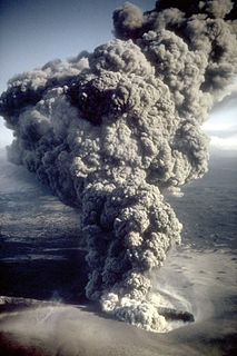
This timeline of volcanism on Earth is a list of major volcanic eruptions of approximately at least magnitude 6 on the Volcanic Explosivity Index (VEI) or equivalent sulfur dioxide emission around the Quaternary period.
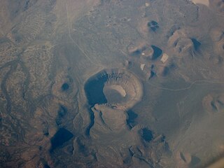
Lunar Crater volcanic field is a volcanic field in Nye County, Nevada. It lies along the Reveille and Pancake Ranges and consists of over two hundred vents, mostly small volcanic cones with associated lava flows but also several maars and Lunar Crater. Some vents have been eroded so heavily that the structures underneath the volcanoes have been exposed. Lunar Crater itself has been used as a testing ground for Mars rovers and as training ground for astronauts.