
Ogdensburg is a borough in Sussex County, New Jersey, United States. As of the 2010 United States Census, the borough's population was 2,410 reflecting a decline of 228 (-8.6%) from the 2,638 counted in the 2000 Census, which had in turn declined by 84 (–3.1%) from the 2,722 counted in the 1990 Census.

Sparta Township is a township in Sussex County, New Jersey, United States. As of the 2010 United States Census, the township's population was 19,722, reflecting an increase of 1,642 (+9.1%) from the 18,080 counted in the 2000 Census, which had in turn increased by 2,923 (+19.3%) from the 15,157 counted in the 1990 Census.

Ogdensburg is a city in St. Lawrence County, New York, United States. The population was 11,128 at the 2010 census. In the late 18th century, European-American settlers named the community after American land owner and developer Samuel Ogden.
The Rutland Railroad was a railroad in the northeastern United States, located primarily in the state of Vermont but extending into the state of New York at both its northernmost and southernmost ends. After its closure in 1963 parts of the railroad were taken over by the State of Vermont and are now operated by the Vermont Railway.

Frederic Sackrider Remington was an American painter, illustrator, sculptor, and writer who specialized in depictions of the American Old West, specifically concentrating on scenes from the last quarter of the 19th century in the Western United States and featuring images of cowboys, American Indians, and the U.S. Cavalry, among other figures from Western culture.

Salgótarján is the capital of Nógrád county, north-eastern Hungary, making it the second smallest county capital based on population.

Allihies is a townland in the civil parish of Kilnamanagh, in County Cork, Ireland. The townland of Allihies is located at the western tip of the Beara Peninsula.
Franklin Furnace, also known as the Franklin Mine, is a famous mineral location for rare zinc, iron, manganese minerals in old mines in Franklin, New Jersey, US. This locale produced more species of minerals and more different fluorescent minerals than any other location. The mineral association (assemblage) from Franklin includes willemite, zincite and franklinite.
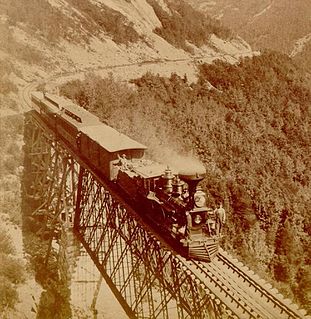
The Portland & Ogdensburg Railroad was a railroad planned to connect Portland, Maine to Ogdensburg, New York. The plan failed, and in 1880 the Vermont section was reorganized and leased by the Boston & Lowell Railroad. In 1886, the Maine and New Hampshire section was reorganized as the Portland & Ogdensburg Railway. That part was leased to the Maine Central Railroad in 1888, and in 1912 the Maine Central leased the eastern part of the Vermont section from the Boston & Maine Railroad, the successor to the B&L.
Sterling Forest State Park is a 21,938-acre (88.78 km2) state park located in the Ramapo Mountains in Orange County, New York. Established in 1998, it is among the larger additions to the New York state park system in the last 50 years.

Anthony's Nose is a peak along the Hudson River at the north end of Westchester County, New York.
New Jersey is a very geologically and geographically diverse region in the United States' Middle Atlantic region, offering variety from the Appalachian Mountains and the Highlands in the state's northwest, to the Atlantic Coastal Plain region that encompasses both the Pine Barrens and the Jersey Shore. The state's geological features have impacted the course of settlement, development, commerce and industry over the past four centuries.

The Ogden Mine Railroad was a mine railroad in the U.S. state of New Jersey from 1866 until 1941.

Redstone is an unincorporated community within the town of Conway in Carroll County, New Hampshire, United States. It is located on the road from Center Conway to North Conway at the base of Rattlesnake Mountain. From the late 19th century until circa 1950, Redstone was known for its quarry of "red" granite which was mined extensively.
Sterlington is a hamlet near the village of Sloatsburg, New York, in the United States.

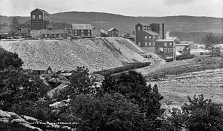
The Sterling Hill Mine, now known as the Sterling Hill Mine Tour & Museum of Fluorescence, is a former iron and zinc mine in Ogdensburg, Sussex County, New Jersey, United States. It was the last working underground mine in New Jersey when it closed in 1986. It became a museum in 1989. Along with the nearby Franklin Mine, it is known for its variety of minerals, especially the fluorescent varieties. It was added to the National Register of Historic Places on 1991.
Backwards Tunnel, also known as the Ogdensburg Railroad Arch, is located in Ogdensburg, Sussex County, New Jersey, United States. The tunnel was added to the National Register of Historic Places on December 28, 2005.

The Marlboro Mountains, sometimes Marlborough Mountains, are a group of hogbacked mountains arranged in a 25-mile-long (40 km) ridge extending from Newburgh, New York to just south of Kingston, New York. Considered to be part of the Ridge and Valley Appalachians, the mountains, which reach elevations over 1,100 feet, form an imposing geologic barrier just west of the Hudson River. They subdivide the relatively flat Hudson River Valley to create the Wallkill Valley further west. Rising abruptly on their eastern flanks, the Marlboro Mountains are known for their sweeping views of the region.

The Edison Ore-Milling Company was a venture by Thomas Edison that began in 1881. Edison introduced some significant technological developments to the iron ore milling industry but the company ultimately proved to be unprofitable. Towards the end of the company's life Edison realised the potential application of his technologies to the cement industry, and formed the Edison Portland Cement Company in 1899.
Edward Long Hedden was Collector of the Port of New York from 1885 to 1886.


