
Burnaby is a city in the Lower Mainland region of British Columbia, Canada. Located in the centre of the Burrard Peninsula, it neighbours the City of Vancouver to the west, the District of North Vancouver across the confluence of the Burrard Inlet with its Indian Arm to the north, Port Moody and Coquitlam to the east, New Westminster and Surrey across the Fraser River to the southeast, and Richmond on the Lulu Island to the southwest.

Coquitlam is a city in the Lower Mainland of British Columbia, Canada. Coquitlam is situated on the traditional, ancestral and unceded territory of the kʷikʷəƛ̓əm. Mainly suburban, Coquitlam is the sixth-largest city in the province, with a population of 139,284 in 2016, and one of the 21 municipalities comprising Metro Vancouver. The mayor is Richard Stewart. Simon Fraser explored the region in 1808, encountering the Indigenous peoples. Europeans started settling in the 1860s. The Fraser Mills, a state-of-the-art lumber mill on the north bank of the Fraser River was constructed in 1889, and by 1908 there were 20 houses, a store, post office, hospital, office block, barber shop, pool hall, and a Sikh temple. Following World War II, substantial population growth was experienced in Coquitlam and Metro Vancouver, which continues to this day.
Port Coquitlam is a city in British Columbia, Canada. Located 27 km (17 mi) east of Vancouver, it is on the north bank of the confluence of the Fraser River and the Pitt River. Coquitlam borders it on the north, the Coquitlam River borders it on the west, and the city of Pitt Meadows lies across the Pitt River from it. Port Coquitlam is almost entirely bisected by Lougheed Highway. Port Coquitlam is often referred to as "PoCo". It is Canada's 88th-largest city by population.

The Millennium Line is the second line of the SkyTrain rapid transit system in the Metro Vancouver region of British Columbia, Canada. The line is owned and operated by BC Rapid Transit Company, a subsidiary of TransLink, and links the cities of Vancouver, Burnaby, Coquitlam and Port Moody. The line was opened in 2002 and was named in recognition of the new millennium.

Highway 7, known for most of its length as the Lougheed Highway and Broadway, is an alternative route to Highway 1 through the Lower Mainland region of British Columbia. Whereas the controlled-access Highway 1 follows the southern bank of the Fraser River, Highway 7 follows the northern bank.

The Burrard Peninsula is a peninsula in the Lower Mainland region of British Columbia, Canada, bounded by the Burrard Inlet to the north, the Georgia Strait to the west, the North Arm of Fraser River to the south, and the Pitt River and Douglas Island to the east. The City of Vancouver occupies almost all of the western half of the peninsula, and the Cities of Burnaby and New Westminster occupy more than half of the eastern half. At its northeastern end, the peninsula is connected to the Eagle Mountain and Mount Burke of the Coast Mountains via a small isthmus at the center of the Tri-Cities.

Lougheed Town Centre is an elevated station on the Expo and Millennium Lines of Metro Vancouver's SkyTrain rapid transit system. The station is located at Lougheed Highway and Austin Road in Burnaby, British Columbia, Canada. Initially a Millennium Line station, a reorganization of SkyTrain service patterns in 2016 brought a branch of the Expo Line over the existing tracks to serve the station. It is one of three stations where transfer between the Expo Line and the Millennium Line is possible, the other two such points of transfer being Commercial–Broadway and Production Way–University stations.

The 99 B-Line is an express bus line with bus rapid transit elements in Metro Vancouver, British Columbia, Canada. It travels along Broadway, a major east–west thoroughfare, and connects the University of British Columbia (UBC) to Commercial–Broadway station on the SkyTrain system. It is operated by Coast Mountain Bus Company and funded by TransLink.

The 97 B-Line was an express bus line in Metro Vancouver, British Columbia, Canada. It connected Coquitlam Central station on the West Coast Express system to Lougheed Town Centre station on the SkyTrain system. It was operated by Coast Mountain Bus Company and funded by TransLink. Going west, the route went along Clarke Rd., St. John's St., Ioco Rd, Guildford Way and Pinetree Way, and served Burnaby, Port Moody, and Coquitlam. The 97 B-Line was discontinued on December 18, 2016, as part of the December 2016 TransLink seasonal bus service changes, many resulting from the opening of the Evergreen Extension of the Millennium Line. The line carried 10,750 passengers on weekdays in 2011.

The City of Lougheed is the second-largest shopping centre in Burnaby, British Columbia, Canada, with 57,100 square metres (615,000 sq ft) and over 160 shops and services. It is located in the northeast corner of Burnaby near the Coquitlam border. The centre is located adjacent to Lougheed Town Centre station, an interchange station that connects the Expo Line and Millennium Line of Metro Vancouver's SkyTrain rapid transit system.

Shaughnessy is an almost-entirely residential neighbourhood in Vancouver, British Columbia, Canada, spanning about 447 hectares in a relatively central locale. It is bordered by 16th Avenue to the north, 41st Avenue to the south, Oak Street to the east, and East Boulevard to the west. The older section of the neighbourhood, called "First Shaughnessy," is considered more prestigious and is bordered by 16th Avenue to the north, King Edward Avenue to the south, Oak Street to the east, and East Boulevard to the west. In 2016, the population was approximately 8,810. It was named after Thomas Shaughnessy, 1st Baron Shaughnessy, former president of the Canadian Pacific Railway.
North Burnaby is a general name for a large neighbourhood in the City of Burnaby, British Columbia, that includes a number of smaller ones. It stretches from Boundary Road in the west to Burnaby Mountain with Simon Fraser University in the east and bounded by Burrard Inlet to the north and the Lougheed Highway to the south. It is a desirable place to live for many local and immigrant families which is reflected by real-estate prices that keep climbing and have doubled in the last 15 years.
Parkcrest is a hillside neighbourhood in North Burnaby adjacent to Kensington Park which gave it its name. It has a long rectangular shape stretched north to south and is bounded by Springer Avenue to the west and Kensington Avenue to the east. To the north its border runs along Hastings Street, its southern border lies along the Lougheed Highway and Skytrain tracks. Its elevation gradually lowers to the south and ends up in Central Valley, quite low above the level of Burnaby Lake.
An electoral redistribution was undertaken in 2008 in British Columbia in a process that began in late 2005 and was completed with the passage of the Electoral Districts Act, 2008 on April 10, 2008. The redistribution modified most electoral boundaries in the province and increased the number of MLAs from 79 to 85. The electoral boundaries created by the redistribution were first used in the 2009 provincial election.

Coquitlam College is a private post-secondary degree-granting institution in Coquitlam, British Columbia. Established in 1982 and authorized by the British Columbia Ministry of Advanced Education to deliver post-secondary education in B.C. under the Degree Authorization Act Coquitlam College offers the following programs: a University Transfer Program, an Associate of Arts Degree Program, a Senior High School Program, and an English Studies Program.
The history of the Jews in Vancouver in British Columbia, Canada has been noted since the mid-19th century.
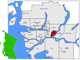
Burquitlam is a neighbourhood and commercial district of the City of Coquitlam, British Columbia, Canada.
Metrotown is a town centre serving the southwest quadrant of Burnaby, British Columbia, Canada. It is one of the city's four officially designated town centres, as well as one of Metro Vancouver's regional town centres. It is the central business district of the City of Burnaby.
An electoral redistribution in British Columbia was undertaken by the BC Electoral Boundaries Commission beginning in 2014 and was formalized by the passage of Bill 42, the 2015 Electoral Districts Act, during the 40th British Columbia Parliament. The act came into effect on November 17, 2015. The redistribution added two seats to the previous total, increasing the number of MLAs in the province from 85 to 87. The electoral boundaries came into effect for the 2017 election. The next redistribution is required to occur following the 2020 British Columbia general election.
