Sunset Ridge is a neighborhood in Victorville, in the Victor Valley region of the Mojave Desert, within San Bernardino County, California.
Sunset Ridge is a neighborhood in Victorville, in the Victor Valley region of the Mojave Desert, within San Bernardino County, California.
The neighborhood is located in southern Victorville, between Interstate 15 and U.S. Route 395, and is northwest of Hesperia.
The community's elevation varies from 3,500–4,000 feet (1,100–1,200 m) above sea level.
The average temperature in summer is about 90°F degrees, and in winter is about 40°F degrees. The average snowfall is at least six inches.

Adelanto is a city in San Bernardino County, California, United States. It is approximately 9 miles (14 km) northwest of Victorville in the Victor Valley area of the Mojave Desert, in the northern region of the Inland Empire. The population was 31,765 at the 2010 census.

Apple Valley is an incorporated town in the Victor Valley of San Bernardino County, in the U.S. state of California. It was incorporated on November 14, 1988, and is one of the 22 incorporated municipalities in California that use "town" in their names instead of "city". The town is east of and adjoining to the neighboring cities of Victorville and Hesperia, 35 miles (56 km) south of Barstow, and 49 miles (79 km) north of San Bernardino through the Cajon Pass. Its population was 75,791 at the 2020.

Mountain View Acres is a census-designated place (CDP) in the Victor Valley of the Mojave Desert, within San Bernardino County, California.

Victorville is a city in Victor Valley in San Bernardino County, California. Its population as of the 2020 census was 134,810.

The Victor Valley is a valley in the Mojave Desert and subregion of the Inland Empire, in San Bernardino County in Southern California.
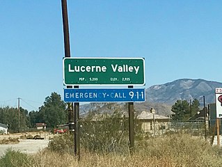
Lucerne Valley is a census-designated place (CDP) and valley landform in the southern Mojave Desert, in western San Bernardino County, California.
Victor Valley College is a public community college in the southeast corner of Victorville, California. It is part of the California Community College System. The Victor Valley Community College district includes Victorville, Hesperia, Apple Valley, Phelan and Adelanto.
Mojave Heights is an unincorporated community in the Victor Valley of the Mojave Desert, within San Bernardino County, California.

George Air Force Base was a United States Air Force base located within the city limits, 8 miles northwest, of central Victorville, California, about 75 miles northeast of Los Angeles, California.
The Mall of Victor Valley is a shopping mall located in Victorville, California. It is owned and managed by Macerich. The mall is located near Interstate 15 and Bear Valley Road.
KVTR is a commercial radio station that is licensed to Victorville, California and serves the Victor Valley area. The station is owned by RuDex Broadcasting and broadcasts a regional Mexican music format branded as "Qué Buena 106.1 FM", referring to its three-watt FM translator K291CM on 106.1 MHz in Victorville.
KATJ-FM is a commercial radio station located in Victorville, California that serves the Victor Valley area. The station is owned by El Dorado Broadcasters and broadcasts a country music format. The official city of license is George, referring to George Air Force Base, which at the station's 1989 sign-on was an active military base and census-designated place. The base was decommissioned in 1992 and later annexed by the city of Victorville.
Desert Valley Hospital (DVH) is an 148-bed osteopathic acute care facility in the city of Victorville, San Bernardino County, California. It serves the Victor Valley region of the south−central Mojave Desert.

High Desert is a vernacular region with non-discrete boundaries applying to areas of the western Mojave Desert in southern California. The "High Desert" region is an area that generally is situated between 2,000 feet (610 m) and 4,000 feet (1,200 m) in elevation, and located just north of the San Gabriel, San Bernardino, and Little San Bernardino Mountains.
KLXD is a K-LOVE affiliate station licensed to Victorville, California, and serving the Victor Valley area.

The Federal Correctional Institution, Victorville are two medium-security United States federal prisons for male inmates in Victorville, California. Part of the Victorville Federal Prison Complex, it is operated by the Federal Bureau of Prisons, a division of the United States Department of Justice.
Chaparral High School is a public high school in the community of Phelan in the Victor Valley of the Mojave Desert, located in San Bernardino County, California.
Bell Mountain is an unincorporated community in the Victor Valley region of the Mojave Desert, within San Bernardino County, southern California.
Adelanto High School is a comprehensive high school of the Victor Valley Union High School District, in Adelanto, California, in the Inland Empire region.

Victorville Army Airfield auxiliary fields were four airfields used during World War II to support the Victorville Army Airfield pilot training near Victorville, California, and Adelanto, California. After the war the Victorville Army Airfield was renamed George Air Force Base on January 13, 1948. The airfields were built in 1941 by the United States Army Air Corps just before the war. Victorville Army Airfield covered 2,200-acre in the Mojave Desert. The US Army held a groundbreaking ceremony on 12 July 1941. The base, called Victorville Army Flying School, was ready to use before the attack on Pearl Harbor on December 7, 1941. The Army built four runways in a triangle configuration, with one runway down the middle of the triangle. Seven hangars were built to support operation. On April 23, 1943, the base was renamed Victorville Army Airfield.
Coordinates: 34°27′14″N117°23′11″W / 34.45389°N 117.38639°W
| | This San Bernardino County, California–related article is a stub. You can help Wikipedia by expanding it. |