Town Island

Last updated
Town Island, viewed from the south. Town Island (07).JPG
Town Island, viewed from the south.
Lighthouse at the northwestern corner of Town Island. Town Island (14).jpg
Lighthouse at the northwestern corner of Town Island.

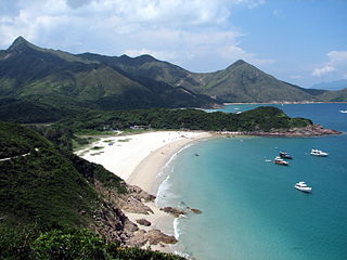
Town Island (Chinese :伙頭墳洲, Fo Tau Fan Chau), also known as Dawn Island [1] is an island in the New Territories of Hong Kong. It is located south of the former High Island, in the Sai Kung District of the territory.

Traditional Chinese characters

Traditional Chinese characters are Chinese characters in any character set that does not contain newly created characters or character substitutions performed after 1946. They are most commonly the characters in the standardized character sets of Taiwan, of Hong Kong and Macau, and in the Kangxi Dictionary. The modern shapes of traditional Chinese characters first appeared with the emergence of the clerical script during the Han Dynasty, and have been more or less stable since the 5th century.

New Territories Place

The New Territories is one of the three main regions of Hong Kong, alongside Hong Kong Island and the Kowloon Peninsula. It makes up 86.2% of Hong Kong's territory, and contains around half of the population of Hong Kong. Historically, it is the region described in the Convention for the Extension of Hong Kong Territory. According to that treaty, the territories comprise the mainland area north of the Boundary Street of Kowloon Peninsula and south of the Sham Chun River, as well as over 200 outlying islands, including Lantau Island, Lamma Island, Cheung Chau, and Peng Chau in the territory of Hong Kong.

Hong Kong East Asian city

Hong Kong, officially the Hong Kong Special Administrative Region of the People's Republic of China and commonly abbreviated as HK, is a special administrative region on the eastern side of the Pearl River estuary in southern China. With over 7.4 million people of various nationalities in a 1,104-square-kilometre (426 sq mi) territory, Hong Kong is the world's fourth most densely populated region.

Contents

A drug rehabilitation centre was established on the island in 1976. [1] It is run by Operation Dawn. [2]

The electricity for the island is supplied from photovoltaics panels by CLP Group.

Photovoltaics method of generating electrical power by converting solar radiation into direct current electricity

Photovoltaics (PV) is the conversion of light into electricity using semiconducting materials that exhibit the photovoltaic effect, a phenomenon studied in physics, photochemistry, and electrochemistry.

CLP Group public company

CLP Group and its holding company, CLP Holdings Ltd, also known as China Light and Power Co Ltd., is an electric company in Hong Kong. Incorporated in 1901 as China Light & Power Company Syndicate, its core business remains the generation, transmission, and retailing of electricity. It also has businesses in a number of Asian markets. It is one of the two main electric power generation companies in Hong Kong, the other being Hongkong Electric Company.

The island is served by a ferry route from Sai Kung twice a day, except public holidays.

See also

Related Research Articles

Kau Sai Chau island

Kau Sai Chau is an island located off the coast of Sai Kung of Hong Kong, with an area of 6.70 km², making it the 6th largest island of Hong Kong. It is under the administration of Sai Kung District.

Tap Mun island in Hong Kong

Grass Island or Tap Mun is an island in Hong Kong, located in the northeastern part of the territory. Its area is 1.69 km². Administratively, it is part of the Tai Po District. There are about 100 people living on the island, and feral cattles are known on the island.

Hoi Ha Wan

Hoi Ha Wan or Jone's Cove is a bay at the north of Sai Kung Peninsula. It is a marine park in Hong Kong.

Sai Kung Peninsula

Sai Kung Peninsula is a peninsula in the easternmost part of the New Territories in Hong Kong. Its name comes from Sai Kung Town in the central southern area of the peninsula. The southern part of the peninsula is administrated by Sai Kung District, the north by Tai Po District and the northwest by Sha Tin District.

Nai Chung

Nai Chung is a countryside in northeastern New Territories, Hong Kong. It is located at the east of Ma On Shan, partly lying within the Ma On Shan Country Park.

Sai Wan Ho Civic Centre

Sai Wan Ho Civic Centre is a community arts centre in Sai Wan Ho, Hong Kong Island, Hong Kong and maintained by the Leisure and Cultural Services Department, one of the successors to the territory's Urban Council.

Ma Liu Shui Place in New Territories, Hong Kong

Ma Liu Shui is an area in Sha Tin District, in the New Territories, Hong Kong.

Sai Kung Town

Sai Kung Town or simply Sai Kung is a town on Sai Kung Peninsula, facing Sai Kung Hoi, part of Sai Kung District in the New Territories, Hong Kong. Sai Kung is the centre of the surrounding villages, and hence the name may refer to the areas in its immediate surroundings.

Long Harbour (Hong Kong)

Long Harbour, also known as Tai Tan Hoi, is a natural harbour formed from an inlet of Mirs Bay to the north of Sai Kung Peninsula, Hong Kong.

Pak Tam Chung human settlement

Pak Tam Chung is an area in the southern part of the Sai Kung Peninsula in the New Territories of Hong Kong. It is administratively under the Sai Kung District.

High Island, Hong Kong former island of Hong Kong

High Island or Leung Shuen Wan is a former island in the southeast of Sai Kung Peninsula, Hong Kong. The island was connected to the peninsula by two dams that enclosed the Kwun Mun Channel (官門海峽), thereby forming the High Island Reservoir. The dams were constructed between 1969 and 1979. The area is part of the Sai Kung East Country Park. It is now a designated fish culture zone and features several seafood restaurants along the shore.

Ma On Shan Road is a major expressway in the new town of Ma On Shan in the New Territories of Hong Kong. The expressway extends northward from Tate's Cairn Highway near Tai Shui Hang along the eastern bank of the Shing Mun River. It ends in the north when it joins Sai Sha Road near Wu Kai Sha. Its branch road, the Ma On Shan Bypass, redirects traffic between Sha Tin and Sai Kung away from the town centre near the Heng On Estate. It is the primary thoroughfare to Ma On Shan, which is locally nicknamed the "center of the universe" in Cantonese.

Sai Kung East Country Park

Sai Kung East Country Park is a 44.77 square kilometres (17.29 sq mi) country park on the Sai Kung Peninsula in Hong Kong. It opened in 1978 and has features including:

Port Shelter human settlement in China

Port Shelter, also known as Ngau Mei Hoi indigenously, is a harbour south of Sai Kung Peninsula in Hong Kong.

Wong Shek Pier

Wong Shek Pier is a public pier on the shore of Long Harbour (赤徑海) in the north-east of Hong Kong's New Territories. It is situated in the Wong Shek (黃石) area of the Sai Kung Peninsula, and is in Tai Po District.

Yim Tin Tsai (Sai Kung) island in Sai Kung District, Hong Kong

Yim Tin Tsai is a small offshore island in Sai Kung, Hong Kong. As of 2013 there is at least one person living on the island again after a long absence of a permanent population.

Shek Chau is a small island in Port Shelter, Sai Kung, Hong Kong. It is under the administration of Sai Kung District.

Kwun Cham Wan is a small island in Port Shelter, Sai Kung, Hong Kong. It is under the administration of Sai Kung District.

Tai Long Wan, Sai Kung human settlement in China

Tai Long Wan is a 3 kilometer-wide bay on the east coast of the Sai Kung Peninsula in Hong Kong. Considered one of the most beautiful places in Hong Kong, it is a popular surf destination. In Chinese, Tai Long Wan translates as Big Wave Bay.

Jockey Club Kau Sai Chau Public Golf Course

Jockey Club Kau Sai Chau Public Golf Course, located on the picturesque island of Kau Sai Chau off the coast of Sai Kung just 15 kilometers away from the town's CBD, is the only public golf course in Hong Kong and one of the world's busiest golf courses.

References

University of Hong Kong university in Hong Kong

The University of Hong Kong (HKU) is a public research university in Hong Kong. Founded in 1911, its origins trace back to the Hong Kong College of Medicine for Chinese, which was founded in 1887. It is the oldest tertiary institution in Hong Kong.

Coordinates: 22°20′4.51″N114°21′53.32″E / 22.3345861°N 114.3648111°E / 22.3345861; 114.3648111

Geographic coordinate system Coordinate system

A geographic coordinate system is a coordinate system that enables every location on Earth to be specified by a set of numbers, letters or symbols. The coordinates are often chosen such that one of the numbers represents a vertical position and two or three of the numbers represent a horizontal position; alternatively, a geographic position may be expressed in a combined three-dimensional Cartesian vector. A common choice of coordinates is latitude, longitude and elevation. To specify a location on a plane requires a map projection.