
Township refers to various kinds of settlements in different countries.

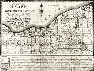
The Public Land Survey System (PLSS) is the surveying method developed and used in the United States to plat, or divide, real property for sale and settling. Also known as the Rectangular Survey System, it was created by the Land Ordinance of 1785 to survey land ceded to the United States by the Treaty of Paris in 1783, following the end of the American Revolution. Beginning with the Seven Ranges, in present-day Ohio, the PLSS has been used as the primary survey method in the United States. Following the passage of the Northwest Ordinance, in 1787, the Surveyor General of the Northwest Territory platted lands in the Northwest Territory. The Surveyor General was later merged with the General Land Office, which later became a part of the U.S. Bureau of Land Management (BLM). Today, the BLM controls the survey, sale, and settling of the new lands.
The Dominion Land Survey (DLS) is the method used to divide most of Western Canada into one-square-mile (2.6 km2) sections for agricultural and other purposes. It is based on the layout of the Public Land Survey System used in the United States, but has several differences. The DLS is the dominant survey method in the Prairie provinces, and it is also used in British Columbia along the Railway Belt, and in the Peace River Block in the northeast of the province.
A civil township is a widely used unit of local government in the United States that is subordinate to a county. The term town is used in New England, New York, and Wisconsin to refer to the equivalent of the civil township in these states. Specific responsibilities and the degree of autonomy vary based on each state. Civil townships are distinct from survey townships, but in states that have both, the boundaries often coincide and may completely geographically subdivide a county. The U.S. Census Bureau classifies civil townships as minor civil divisions. Currently, there are 20 states with civil townships.
The term township, in Canada, is generally the district or area associated with a town. The specific use of the term to describe political subdivisions has varied by country, usually to describe a local rural or semirural government within the country itself.
A township in the United States is a small geographic area.

The Land Ordinance of 1785 was adopted by the United States Congress of the Confederation on May 20, 1785. It set up a standardized system whereby settlers could purchase title to farmland in the undeveloped west. Congress at the time did not have the power to raise revenue by direct taxation, so land sales provided an important revenue stream. The Ordinance set up a survey system that eventually covered over 3/4 of the area of the continental United States.
Survey township, sometimes called Congressional township, as used by the United States Public Land Survey System, refers to a square unit of land, that is nominally six miles (~9.7 km) on a side. Each 36-square-mile (~93 km2) township is divided into 36 one-square-mile (~2.6 km2) sections, that can be further subdivided for sale, and each section covers a nominal 640 acres (2.6 km2). The townships are referenced by a numbering system that locates the township in relation to a principal meridian (north-south) and a base line (east-west). For example, Township 2 North, Range 4 East is the 4th township east of the principal meridian and the 2nd township north of the base line. Township (exterior) lines were originally surveyed and platted by the US General Land Office using contracted private survey crews. Later survey crews subdivided the townships into sections (interior) lines. Virtually all lands covered by this system were sold according to these boundaries. They are marked on the U.S. Geological Survey topographic maps.

In U.S. land surveying under the Public Land Survey System (PLSS), a section is an area nominally one square mile, containing 640 acres, with 36 sections making up one survey township on a rectangular grid.

Seward Township is located in Winnebago County, Illinois. As of the 2010 census, its population was 917 and it contained 394 housing units.

Winnebago Township is located in Winnebago County, Illinois, United States. As of the 2010 census, its population was 5,291, and it contained 1,976 housing units.
Batavia Township is in Kane County, Illinois. It is divided by the Fox River. As of the 2010 census, its population was 35,221 and it contained 12,892 housing units. The western part of the United States Department of Energy's Fermilab is at the township's eastern edge, although most of the facility is in neighboring Winfield Township in DuPage County.

Big Rock Township is located in Kane County, Illinois. As of the 2010 census, its population was 1,859 and it contained 717 housing units. Most of its land use is agricultural.

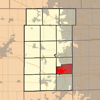
Oswego Township occupies the 6-mile-square-plus additional land to the south of the Fox River in northeast corner of Kendall County, Illinois. As of the 2010 census, its population was 50,870 and it contained 17,914 housing units.
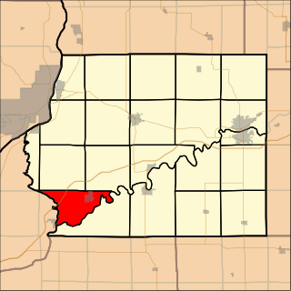
Erie Township is located in Whiteside County, Illinois. As of the 2010 census, its population was 2,006 and it contained 836 housing units.

Jordan Township is located in Whiteside County, Illinois. As of the 2010 census, its population was 899 and it contained 354 housing units.

Cold Brook Township is located in Warren County, Illinois, United States. As of the 2010 census, its population was 467 and it contained 196 housing units.
School Lands are land grants established in support of education. Support for public education in the United States predates the constitution; two years before the adoption of the United States Constitution of 1787, the Congress of the Confederation provided support for public schooling by establishing the land grants in the Land Ordinance of May 20, 1785 which granted Section 16 of every township to be used for public education: "There shall be reserved the Lot No. 16, of every township, for the maintenance of public schools within said township."