Related Research Articles
Muskogee County is a county located in the U.S. state of Oklahoma. As of the 2020 census, the population was 66,339. The county seat is Muskogee. The county and city were named for the Muscogee (Creek) Nation. The official spelling of the name was changed to Muskogee by the post office in 1900.

Lowndes County is a county located in the south-central portion of the U.S. state of Georgia. As of the 2020 census, the population was 118,251. The county seat is Valdosta. The county was created December 23, 1825.

Glynn County is located in the southeastern part of the U.S. state of Georgia. As of the 2020 census, the population was 84,499. The county seat is Brunswick. Glynn County is part of the Brunswick, Georgia Metropolitan Statistical Area.

Columbia County is a county located in the east central portion of the US state of Georgia. As of the 2020 census, the population was 156,010. The legal county seat is Appling, but the de facto seat of county government is Evans.

Charlton County is the southernmost county of the U.S. state of Georgia, located in the southeastern part of the state. As of the 2020 census, the population was 12,518. The county seat is Folkston.

Camden County is a county located in the southeastern corner of the U.S. state of Georgia. According to the 2020 census, its population was 54,768. Its county seat is Woodbine, and the largest city is Kingsland. It is one of the original counties of Georgia, created February 5, 1777. It is the 11th-largest county in the state of Georgia by area, and the 41st-largest by population.

Brantley County is a county located in the southeastern part of the U.S. state of Georgia. As of the 2020 census, the population was 18,021. The county seat is Nahunta. Brantley County is part of the Brunswick, Georgia metropolitan statistical area.

St. Marys is a city in Camden County, Georgia, United States, located on the southern border of Camden County on the St. Marys River in the state's Low Country. The Florida border is just to the south across the river, Cumberland Island National Seashore is to the northeast, and Kingsland, Georgia, is to the west. Jacksonville, Florida, is 38 miles south, and Savannah, Georgia, is 110 miles north.
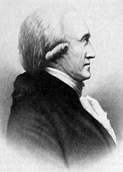
Benjamin Hawkins was an American planter, statesman and a U.S. Indian agent. He was a delegate to the Continental Congress and a United States Senator from North Carolina, having grown up among the planter elite. Appointed by George Washington in 1796 as one of three commissioners to the Creeks, in 1801 President Jefferson named him "principal agent for Indian affairs south of the Ohio [River]", and was principal Indian agent to the Creek Indians.

Ocmulgee Mounds National Historical Park in Macon, Georgia, United States preserves traces of over ten millennia of culture from the Native Americans in the Southeastern Woodlands. Its chief remains are major earthworks built before 1000 CE by the South Appalachian Mississippian culture These include the Great Temple and other ceremonial mounds, a burial mound, and defensive trenches. They represented highly skilled engineering techniques and soil knowledge, and the organization of many laborers. The site has evidence of "12,000 years of continuous human habitation." The 3,336-acre (13.50 km2) park is located on the east bank of the Ocmulgee River. Macon, Georgia developed around the site after the United States built Fort Benjamin Hawkins nearby in 1806 to support trading with Native Americans.

Fort Hawkins was a fort built between 1806 and 1810 in the historic Creek Nation by the United States government under President Thomas Jefferson and used until 1824. Built in what is now Georgia at the Fall Line on the east side of the Ocmulgee River, the fort overlooked the sacred ancient earthwork mounds of the Ocmulgee Old Fields, now known as the Ocmulgee Mounds National Historical Park. The Lower Creek Trading Path passed by just outside the fort's northwestern blockhouse, and continued in a westerly direction until it reached a natural ford on the Ocmulgee River. A trading settlement and later the city of Macon, Georgia, developed in the area prior to the construction of the fort, with British traders being in the area as early as the 1680s. Later, the fort would become important to the Creek Nation, the United States, and the state of Georgia for economic, military, and political reasons.
Standing Peachtree was a Muscogee village and the closest Indian settlement to what is now the Buckhead area of Atlanta, Georgia. It was located where Peachtree Creek flows into the Chattahoochee River, in today's Paces neighborhood. It was located in the borderlands of the Cherokee and Muscogee nations. It is referred to in several documents dating as far back as 1782.

Brigadier-General John Floyd was an American politician, planter and military officer who served in the 1st Brigade of the Georgia Militia during the War of 1812. One of the largest landowners and wealthiest men in Camden County, Georgia, Floyd also served in the Georgia House of Representatives, as well as the United States House of Representatives.
Hitchiti was a tribal town in what is now the Southeast United States. It was one of several towns whose people spoke the Hitchiti language. It was first known as part of the Apalachicola Province, an association of tribal towns along the Chattahoochee River. Shortly after 1690, the towns of Apalachicola Province moved to the central part of present-day Georgia, with Hitchiti joining most of those towns along Ochese Creek. In 1715, most of the towns on Ochese Creek, including Hitchiti, moved back to the Chattahoochee River, where the town remained until its people were forced to move to Indian Territory as part of the Trail of Tears.
The Warren Wagon Train raid, also known as the Salt Creek massacre, occurred on May 18, 1871. Henry Warren was contracted to haul supplies to forts in the west of Texas, including Fort Richardson, Fort Griffin, and Fort Concho. Traveling down the Jacksboro-Belknap road heading towards Salt Creek Crossing, they encountered William Tecumseh Sherman. Less than an hour after encountering the famous General, they spotted a rather large group of riders ahead. They quickly realized that these were Native American warriors, probably Kiowa and/or Comanche.

Old Crow Wing is a ghost town in Fort Ripley Township, Crow Wing County, Minnesota, United States, at the confluence of the Mississippi and Crow Wing rivers. Long occupied by the Ojibwe people, for over a century it was also the northernmost European-American settlement on the Mississippi.
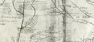
Moniac is an unincorporated community situated along the St. Marys River, in southern Charlton County in the U.S. state of Georgia. Part of the "Georgia Bend", the area was an early trading post in the 1820s as the last outpost before crossing into the Florida territory. The settlement's name comes from Colonel David Moniac, a creek Indian and West Point graduate who was killed during the second Seminole Indian War. The fort was dismantled in 1842.

According to the Encyclopedia of Oklahoma History and Culture, there were two trails that may have been known as the California Road at the time of the California Gold Rush. A southerly route, which ran through present-day Oklahoma, along the Canadian River. A northern route was usually called the California Trail.

The Battle of Fort Point Peter was a successful attack in early 1815 by a British force on a smaller American force on the Georgia side of the St. Marys River near St. Marys, Georgia. The river was then part of the international border between the United States and British-allied Spanish Florida; it now forms part of the boundary between Georgia and Florida. Occupying coastal Camden County allowed the British to blockade American transportation on the Intracoastal Waterway. The attack on Forts St. Tammany and Peter occurred in January 1815, after the signing of the Treaty of Ghent, which would end the War of 1812, but before the treaty's ratification. The attack occurred at the same time as the siege of Fort St. Philip in Louisiana and was part of the British occupation of St. Marys and Cumberland Island.
The Battle of Flint River, also called the Spanish-Indian Battle (1702), was a failed attack by Spanish and Apalachee Indian forces against Creek Indians in October 1702 in what is now the state of Georgia. The battle was a major element in ongoing frontier hostilities between English colonists from the Province of Carolina and Spanish Florida, and it was a prelude to more organized military actions of Queen Anne's War.
References
- ↑ American State Papers. Indian Affairs, Vol. I. p. 374, 379, 363, 406, 313, 367.
- ↑ Krakow, Kenneth K. (1975). Georgia Place-Names: Their History and Origins (PDF). Macon, GA: Winship Press. p. 230. ISBN 0-915430-00-2.
- ↑ "Trader's Hill". Charltoncountyarchives.org. Retrieved 2013-07-30.
