
Traffic on roads consists of road users including pedestrians, ridden or herded animals, vehicles, streetcars, buses and other conveyances, either singly or together, while using the public way for purposes of travel. Traffic laws are the laws which govern traffic and regulate vehicles, while rules of the road are both the laws and the informal rules that may have developed over time to facilitate the orderly and timely flow of traffic.
Interstate 27 (I-27) is an Interstate Highway, entirely in the U.S. state of Texas, running north from Lubbock to Interstate 40 in Amarillo. These two cities are the only control cities on I-27; other cities and towns served by I-27 include New Deal, Abernathy, Hale Center, Plainview, Kress, Tulia, Happy, and Canyon. In Amarillo, I-27 is commonly known as the Canyon Expressway, although it is also called Canyon Drive on its access roads. I-27 was officially designated the Marshall Formby Memorial Highway after former attorney and Texas State Senator Marshall Formby in 2005. The entire length of I-27 replaced U.S. Route 87 for through traffic.
Interstate 45 (I-45) is an Interstate Highway located entirely within the U.S. state of Texas. While most Interstate routes ending in "5" are cross-country north-south routes, I-45 is comparatively short, with the entire route located in Texas. It connects the cities of Dallas and Houston, continuing southeast from Houston to Galveston over the Galveston Causeway to the Gulf of Mexico.
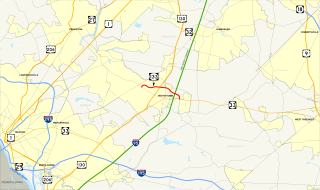
Route 133 is a short state freeway located entirely in East Windsor Township, Mercer County, New Jersey in the United States. The route runs as a 4.42-mile-long (7.11 km) four-lane bypass of Hightstown from County Route 571 (CR 571) at Windsor Center Drive to the New Jersey Turnpike / Interstate 95 (I-95) at exit 8. Originally, Route 133 did not have any direct connections to any other limited access roads until a new Turnpike interchange opened in January 2013.

A frontage road is a local road running parallel to a higher-speed, limited-access road. A frontage road is often used to provide access to private driveways, shops, houses, industries or farms. Where parallel high-speed roads are provided as part of a major highway, these are also known as local-express lanes.
Interstate 285 (I-285) is an Interstate Highway loop encircling Atlanta, Georgia, for 63.98 miles (102.97 km). It connects the three major interstate highways to Atlanta: I-20, I-75 and I-85. Colloquially referred to as The Perimeter, it also carries unsigned State Route 407 (SR 407), and is signed as Atlanta Bypass on I-75/I-85.

A shoulder, or hard shoulder is an emergency stopping lane by the verge of a road or motorway, on the right in countries which drive on the right, or on the left side in India, Japan, the UK, Australia, and other left-side driving countries. Many wider US and Swedish freeways have shoulders on both sides of each directional carriageway, in the median as well as at the outer edges of the road, for additional safety. Shoulders are not intended for use by through traffic, although there are exceptions.

In the context of traffic control, a lane is part of a roadway (carriageway) that is designated to be used by a single line of vehicles, to control and guide drivers and reduce traffic conflicts. Most public roads (highways) have at least two lanes, one for traffic in each direction, separated by lane markings. On multilane roadways and busier two-lane roads, lanes are designated with road surface markings. Major highways often have two multi-lane roadways separated by a median.

The South Eastern Freeway is a 76 kilometre controlled-access highway in South Australia. It carries traffic over the Adelaide Hills between Adelaide and the River Murray, near Murray Bridge, connecting via the Swanport Bridge to the Dukes Highway which is the main road route to Victoria. It is often referred to by South Australians simply as the Freeway, as it was the first freeway in South Australia, and is still the longest, and the only one with "Freeway" in its name rather than "Expressway" or "Highway". It is a part of the National Highway network linking the state capital cities Adelaide to Melbourne and signed as National Highway M1. The South Eastern Freeway includes 500-metre-long twin-tube tunnels in the descent towards Adelaide, the first of their kind on the National Highway. It is designated as the M1.

A passing lane or overtaking lane (English) is a lane on a multi-lane highway or motorway closest to the median of the road. In some countries, lanes are described as being on the 'inside' or the 'outside' of a road, and the location of the passing lanes will vary.

A controlled-access highway is a type of highway which has been designed for high-speed vehicular traffic, with all traffic flow ingress- and egress-regulated. Common English terms are freeway, motorway and expressway. Other similar terms include Interstate and thruway and parkway. Some of these may be limited-access highways, although this term can also refer to a class of highway with somewhat less isolation from other traffic.
Interstate 95 (I-95) in Maryland is a major highway that runs 109.01 miles (175.43 km) diagonally from northeast to southwest, from Maryland's border with Delaware, to the Woodrow Wilson Bridge, entering the District of Columbia and reaching Virginia. The route is one of the most traveled Interstate Highways in Maryland, especially between Baltimore and Washington, D.C., despite alternate routes along the corridor, such as the Baltimore-Washington Parkway, U.S. Route 1, and US 29. Portions of the highway are tolled.
Interstate 95 (I-95) is the main Interstate Highway of Florida's Atlantic Coast. It begins at a partial interchange with U.S. Highway 1 (US 1) just south of downtown Miami, and heads north past Daytona Beach, through Jacksonville, and to the Georgia state line at the St. Marys River near Becker. The route also passes through the cities of Fort Lauderdale, West Palm Beach, and Titusville.
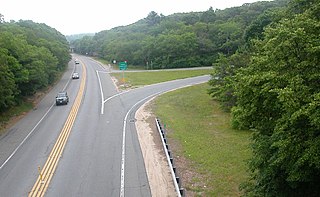
A two-lane expressway or two-lane freeway is an expressway or freeway with only one lane in each direction, and usually no median barrier. It may be built that way because of constraints, or may be intended for expansion once traffic volumes rise. The term super two is often used by roadgeeks for this type of road, but traffic engineers use that term for a high-quality surface road. Most of these roads are not tolled.

The Newhall Pass Interchange is a highway interchange at Newhall Pass, north of Sylmar in Southern California, United States. It connects Interstate 5 with State Route 14. It is officially named in the memory of Los Angeles Police officer Clarence Wayne Dean, who was killed when the interchange collapsed during the 1994 Northridge earthquake.
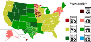
Speed limits in the United States vary depending on jurisdiction. Rural freeway speed limits of 75 to 80 mph are common in the Western United States, while such highways are typically posted at 65 to 70 mph in the Eastern United States. States may also set separate speed limits for trucks and night travel along with minimum speed limits. The highest speed limit in the country is 85 mph (140 km/h), which is posted on a single stretch of tollway in rural Texas. The lowest maximum speed limit in the country is 30 miles per hour (48 km/h) in American Samoa.

Terminology related to road transport—the transport of passengers or goods on paved routes between places—is diverse, with variation between dialects of English. There may also be regional differences within a single country, and some terms differ based on the side of the road traffic drives on. This glossary is an alphabetical listing of road transport terms.

A managed lane is a type of highway lane that is operated with a management scheme, such as lane use restrictions or variable tolling, to optimize traffic flow, vehicle throughput, or both. Definitions and goals vary among transport agencies, but managed lanes are generally implemented to achieve an improved operational condition on a highway, such as improving traffic speed and throughput, reducing air pollution, and improving safety. Types of managed lanes include High-occupancy vehicle (HOV) lanes, High-occupancy toll lanes, express toll lanes, reversible lanes, and bus lanes. Most managed lane facilities are located in the United States, although HOV and bus lanes can be found in many other countries; outside of the US, many countries use active traffic management that manage all lanes of a highway.


