USC&GS Marinduque

Last updated
USC&GS Marinduque.jpg
USC&GS Marinduque in the Philippine Islands.
History
US flag 45 stars.svg Flag of the United States Coast and Geodetic Survey.svg United States
NameMarinduque
NamesakeThe island of Marinduque in the Philippine Islands
OwnerPhilippine Insular Government
Operator
  • Philippine Bureau of Coast Guard and Transportation
  • U.S. Coast and Geodetic Survey/Philippine Insular Government
Cost$67,673.42 (USD)
Laid downprobably 1902
Launchedprobably 1902 [note 1]
CompletedDelivered Manila 18 April 1903
Acquiredby Coast & Geodetic Survey November 1, 1905
Commissioned1905
DecommissionedSeptember 20, 1932
IdentificationSignal: MCLF [1]
General characteristics
Type Survey ship
Tonnage411  GRT [1]
Displacement345 tons [1]
Length132 ft (40.2 m) Registered
Beam23 ft (7.0 m)
Draft10.2 ft (3.1 m)
Propulsion Steam engine, 2 screws
Speed8 kn (9.2 mph; 15 km/h) [1]
Complement9 officers, 37 men [1]

USC&GS Marinduque was a steamer, owned by the Philippine Insular Government, that served exclusively in the Philippines. The ship was purchased by the Philippine Bureau of Coast Guard and Transportation to support both government logistical and administrative travel needs as well as the usual functions of a coast guard vessel. The vessel was transferred to the United States Coast and Geodetic Survey serving as a survey ship from 1905 to 1932. Marinduque and Romblon were sister ships, both built in Japan.

Contents

Acquisition

The Philippine Bureau of Coast Guard and Transportation shortly after creation 17 October 1901 and organizing with Captain A. Marix, USN, in charge had ten 148 ft (45.1 m) single screw cutters under contract at Farnham, Boyd & Company, Shanghai, China and five twin screw cutters contracted at Uraga Dock Company, Uraga, Japan. All vessels were to have both passenger and cargo capability as one purpose was to have official communication between isolated parts of the islands and administrative centers. They were to be steel framed with teak hull with copper sheathing with accommodation for about twelve passengers and 150 tons of cargo. Those for the vessels constructed at Uraga Dock Company were for length overall 140 ft (42.7 m), 23 ft (7.0 m) breadth, and a maximum draft of 8 ft (2.4 m) with a speed of 10 kn (12 mph; 19 km/h). [2] [3] [note 2] Marinduque was built at a cost of $67,673.42, [4]

The cutters delivered by Farnham, Boyd & Company were satisfactory, meeting requirements. Romblon, arriving in Manila on 19 January 1903, and Marinduque that arrived 18 April 1903 were did not meet specifications. Romblon had been accepted by the agent in Japan, later dismissed for neglect of duty, but was found on delivery to have a draft exceeding maximum by 1 ft (0.3 m) to 1.5 ft (0.5 m) and when loaded with coal, water and ready for sea was down by the bow. Further, the "material and workmanship on hull, boilers, and engine were very poor" as well as the vessel not meeting speed and sea keeping requirements. Some corrections were made on Marinduque but on delivery the same poor workmanship and material quality was present along with some uncorrectable deficiencies. As a result, and negotiations with a director of the builder summoned to Manila, a settlement was reached to cancel the remaining three ships but with a loss of about $30,000 to the government. [3]

There is a discrepancy in the build date for the ships with the normally authoritative register having a 1901 date and it is probably that date used in the USC&GS dates of later years. It is obvious from the fact the organization that ordered the vessels, the Bureau of Coast Guard and Transportation, only formed on 17 October 1901 and the delivery dates are January and April of 1903 that a 1901 date is not reasonable. It is possible that is the contract date and the vessels were under construction in 1902 as the three hulls cancelled were still incomplete when the problems with the Uraga construction became evident.

Service with Philippine Coast Guard

There is little record of service details. The cutters were commanded by American or European officers with Filipino petty officers and crewmen. The system was set so that vessels served particular routes serving communication and transportation functions with duties of coast guard in patrol and other typical duties of such a service being accomplished within that service. All vessels were lightly armed. They also acted as transports for both troops and law enforcement when necessary. [3] [5]

Transfer to Coast and Geodetic Survey

Marinduque was transferred from the Philippine Commission to the Coast and Geodetic Survey for Philippine survey work on November 1, 1905. [6] For operations in the Philippines the U.S. Government paid salaries, cost of travel to and from the Philippines and expenses for the U.S. Coast and Geodetic Survey officers aboard the ships. The insular government paid crew salaries and expenses as well as having ownership of the vessels excepting the Pathfinder. [7] All crews were Filipino. [8]

Service history

Marinduque left Manila December 10, 1905 for her initial surveys on the west coast of Leyte between "Illongas" [note 3] and "Polompon", then after a period in Manila April 10–23, 1906, the east coast of Luzon between Atimonan and Polillo island. [6]

The work around Polillo island was in progress until October 10, 1908 when weather required suspension and return to Manila with the position of Ocata Island light house established. Seven typhoons had passed over the region and destruction of survey navigation marks was noted. After repairs at Manila the ship sailed January 25, 1909 for the south coast of Mindanao. at the request of military authorities due to open hostilities in the area. A detachment of twenty-two Philippine Scouts was taken aboard at Fort Margosatubig on January 30, 1909 and shore parties for the survey in the densely forested coast were armed and under armed escort during triangulation and topographic surveys of the shoreline. [9] P. E. Angell, one of Marinduque's mates, drowned while attempting to reach a small boat anchored off Sigayan Point in Illana Bay on the south coast of Mindanao. [10]

On more than one occasion, Marinduque had occasion to assist mariners in distress. On 21 October 1916, she came to the aid the schooner Florence, which was in distress with her sails blown away, part of her rigging gone, and her food and water low; Marinduque towed Florence to Coron on Palawan and then took Florence's captain from Coron to Manila on Luzon. On 7 July 1927, she helped the British steamer Paipeng, which was aground on Cap Island in the Philippines; Marinduque took off the majority of Paipeng's passengers and transported them to Jolo.

The ship was transferred to the Insular Bureau of Labor March 19, 1918 and alterations made for use as an inter-island cargo ship with its condition on return to the Coast and Geodetic Survey July 7, 1919 requiring work restoring the ship to seaworthy condition and suitability for surveys until September 26, 1919. During 1920, due to the Navy's discontinuing coaling of the C&GS ships, work took place convenient to an offer of coal by the governor of Mindanao and coal mines at Sandakan, Borneo where Marinduque surveyed in company with Pathfinder on the west coast of Mindanao, the Sulu Sea and Palawan closest to the coaling station at Sandakan. Much of Marinduque's work involved establishing the a triangulation network on the west coast of Mindanao on the Zamboanga Peninsula for survey navigation. [11]

Marinduque, in Manila and just after extensive repairs, was fouled by another ship that broke from moorings during a typhoon that hit the city August 31, 1920 and sustained considerable damage while Romblon lost a whaleboat and the Manila tide station was demolished. Marinduque was inactive July 1, 1920 through March 15, 1921 with Romblon inactive the entire fiscal year due to inability to furnish C&GS officers for the ships and full reports only cover Pathfinder and Fathomer as actively surveying. From March 16 through May 13 Marinduque worked Bacoor Bay, Cavite and from May 24 through June 30 in Albay Gulf and Lagonoy Gulf. [12]

Fate

Marinduque completed operations in the Sulu Archipelago August 31, 1932 and returned to Manila where the ship was decommissioned September 20, 1932 then sold by the Philippine Government. [13]

Footnotes

  1. See discussion of discrepancies in text.
  2. The required length of 140 ft (42.7 m) and length given in registry and NOAA sources of 132 ft (40.2 m) most likely reflects that the registry length is slightly less than overall length. Cited documents do not give a final measurement of length overall as delivered.
  3. Period spelling used.

Related Research Articles

<span class="mw-page-title-main">Philippine Coast Guard</span> Coast guard of the Philippines

The Philippine Coast Guard (PCG) is recognized as the third armed uniformed service of the country attached to the Philippines' Department of Transportation, tasked primarily with enforcing laws within Philippine waters, conducting maritime security operations, safeguarding life and property at sea, and protecting marine environment and resources; similar to coast guard units around the world. In case of a declaration of war, the Coast Guard shall also serve as an attached service of the Department of National Defense.

<span class="mw-page-title-main">Montenegro Lines</span> Batangas based shipping company

Montenegro Shipping Lines, Inc. (MSLI) is a Philippine domestic shipping line based at Batangas City, Philippines. The office is located at Montenegro Corporate office, along Bolbok Diversion Road, Bolbok Batangas City. It operates passenger, cargo and RORO vessels to various destinations in the Philippines under the brands Montenegro Lines and Marina Ferries.

<span class="mw-page-title-main">United States Coast and Geodetic Survey</span> Former U.S. government scientific agency

The United States Coast and Geodetic Survey, known from 1807 to 1836 as the Survey of the Coast and from 1836 until 1878 as the United States Coast Survey, was the first scientific agency of the United States Government. It existed from 1807 to 1970, and throughout its history was responsible for mapping and charting the coast of the United States, and later the coasts of U.S. territories. In 1871, it gained the additional responsibility of surveying the interior of the United States and geodesy became a more important part of its work, leading to it being renamed the U.S. Coast and Geodetic Survey in 1878.

USC&GS <i>Natoma</i> Patrol vessel of the United States Navy

USC&GS Natoma was built as the private motorboat Natoma in 1913 for Charles H. Foster, President of the Cadillac Motor Car Company of Chicago. In 1917 the United States Navy acquired the boat for use in World War I. The vessel was commissioned USS Natoma for Section Patrol duties and designated SP-666. Natoma spent the war years patrolling New York harbor and approaches. On 9 April 1919 the boat was transferred to United States Coast and Geodetic Survey surveying on both coasts until 1935.

USC&GS <i>E. Lester Jones</i>

USC&GS E. Lester Jones (ASV-79) was a survey ship that served in the United States Coast and Geodetic Survey Pacific service, mainly in Alaskan surveys, from 1940 to 1967. The vessel was built by Astoria Marine Construction Company at Astoria, Oregon, completed and entered Coast and Geodetic Survey service in 1940. E. Lester Jones was of wooden construction, 88 ft (26.8 m) in length, 21 ft (6.4 m) beam with 8 ft (2.4 m) draft and displacement of 150 tons. The 1941 assigned call letters were WETH.

USC&GS <i>Fathomer</i> (1904) American geodetic survey ship (1905–1942)

The second USC&GS Fathomer was a steamer that served as a survey ship in the United States Coast and Geodetic Survey from 1905 to 1942.

USC&GS <i>Romblon</i>

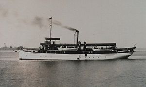
USC&GS Romblon was a steamer, owned by the Philippine Insular Government, that served exclusively in the Philippines. The ship was purchased by the Philippine Bureau of Coast Guard and Transportation to support both government logistical and administrative travel needs as well as the usual functions of a coast guard vessel. The vessel was transferred to the United States Coast and Geodetic Survey serving as a survey ship from 1905 to 1932. Romblon and Marinduque were sister ships, both built in Japan.

USC&GSS <i>Research</i>

USC&GSS Research was a survey vessel owned by the Philippine Insular Government to be the first vessel operated by the United States Coast and Geodetic Survey in the Philippines from 1901 until 1918.

USC&GSS <i>Pathfinder</i>

The first USC&GSS Pathfinder, also noted in some NOAA histories as "old Pathfinder", was a United States Coast and Geodetic Survey ship in service from 1899 to 1941, when she was beached in sinking condition on January 30, 1942, after 40 years service in the Philippines.

Batag Island Lighthouse is a historic lighthouse on Batag Island off the coast of the town of Laoang in the province of Northern Samar in the Philippines. The light marks the northeastern point of Samar Island and led international ships to the entrance of the San Bernardino Strait marked by the San Bernardino Light. One of the most traveled waterways in the archipelago, together with the Capul Island Light, these stations are invaluable to vessels coming from the Pacific Ocean and entering the country through the San Bernardino Strait on its way to Manila or any other ports of the Philippines.

<span class="mw-page-title-main">Apo Reef Lighthouse</span> Lighthouse in the Philippines

The Apo Reef Light was a historic lighthouse built on Bajo Apo Island in Apo Reef Natural Park. The park is located in the middle of Mindoro Strait, west of the province of Occidental Mindoro, in the Philippines. The station was established to warn ships of the dangerous shallow reefs in that part of the strait.

Bagatao Island Lighthouse is a historic lighthouse located on Bagatao Island on the eastern side of the entrance to Sorsogon Bay, in the province of Sorsogon in the Philippines. The 29-ft white cylindrical iron tower is situated on the rocky headland that forms the southern point in the western end of the Island, giving the total light elevation of 135 ft. The light not only marks the entrance to the bay, but also assist ships in navigating the bend around Ticao Island of Masbate province as they head to San Bernardino Strait and exit to the Pacific Ocean.

<span class="mw-page-title-main">Corregidor Island Lighthouse</span> Lighthouse in the Philippines

The first Corregidor Island Lighthouse was a historic lighthouse located on the island of Corregidor, in the province of Cavite, Philippines. The light station was one of the most important lights in the archipelago. It was established in 1853 to guide ships to the entrance of Manila Bay on their way to the port of Manila, the most important trading center in the country. This light occupies the converging point of two lines of approach for vessels from the China Sea which steer for the entrance of Manila Bay. Vessels from Hong Kong and the ports of China to the northwest first sight the Capones Island light off the southwest coast of Zambales. Vessels from ports of Indo-China first sight the Corregidor lights in the center. Vessels from Singapore, Indonesia, India, and all the ports of the Philippine Islands, to the south, first sight the Cabra Island light. All lines converge on Corregidor light at the bay entrance.

USC&GS <i>George S. Blake</i>

USC&GS George S. Blake, in service 1874–1905, is, with the U.S. Fish Commission steamer Albatross, one of only two US oceanographic vessels with her name inscribed in the façade of the Oceanographic Museum, Monaco due to her being "the most innovative oceanographic vessel of the Nineteenth Century" with development of deep ocean exploration through introduction of steel cable for sounding, dredging and deep anchoring and data collection for the "first truly modern bathymetric map of a deep sea area."

USC&GS <i>A. D. Bache</i> (1871)

USC&GS A. D. Bache, the second steamer of the United States Coast and Geodetic Survey, was named for Alexander Dallas Bache, a former superintendent of the Survey. She was launched in August 1871 at Wilmington, Delaware, and was in commission from 1871 to 1900.

USS <i>Onward</i> (SP-311) Patrol vessel of the United States Navy

USS Onward (SP-311), a former yacht named Galatea and then Ungava was a patrol yacht acquired by the U.S. Navy during World War I. She was transferred to the United States Coast and Geodetic Survey where she served briefly until return to the Navy for a brief time before her disposal by sale. She was renamed Thelma Phoebe.

USC&GS Drift was a United States Coast Survey schooner built in 1876 specifically to anchor in offshore waters to undertake current measurements. She was transferred to the United States Lighthouse Board on May 20, 1893 to become the lightship Light Vessel # 97 or (LV-97) on the Bush Bluff station until retirement and sale in 1918 to become the W. J. Townsend which was scrapped in 1945.

USC&GS <i>Explorer</i> (1904)

The first USC&GS Explorer was a steamer that served as a survey ship in the United States Coast and Geodetic Survey from 1904 to 1939 except for a brief time in United States Navy service from 1918 to 1919 for patrol duty in Alaskan waters as USS Explorer during World War I. After initial service along the United States East Coast and off Puerto Rico, the ship transferred to Seattle, Washington in 1907 to begin survey work in Alaskan waters during summer and more southern waters along the United States West Coast in winter. On her return from the Navy in 1919, the ship was condemned and due to be sold but instead was retained as a survey vessel into the fall of 1939. After a stint with the National Youth Administration from 1939 to 1941, she saw service during World War II with the United States Army Corps of Engineers as the freight and supply ship Atkins.

USS <i>Helianthus</i> Patrol vessel of the United States Navy

USS Helianthus (SP-585) was a patrol vessel in commission in the United States Navy from 1917 to 1919, seeing service in World War I. After her U.S. Navy service, she was in commission in the United States Coast and Geodetic Survey as the survey launch USC&GS Helianthus from 1919 to 1939. She was named after the Helianthus, the genus to which the sunflower belongs.

<span class="mw-page-title-main">Gorda Point Lighthouse</span> Historic lighthouse in the Philippines

Gorda Point Lighthouse, is a historic lighthouse located about 248 kilometers (154 mi) southeast of Manila in Barangay Cawayan, San Agustin, Romblon, Philippines. It serves as a guide for ships traversing the Romblon Pass between the islands of Tablas and Romblon.

References

  1. 1 2 3 4 5 Forty-Seventh Annual List of Merchant Vessels of the United States, Year ended June 30, 1915. Washington, D.C.: Department of Commerce and Labor, Bureau of Navigation. 1915. p. 464. Retrieved 4 November 2018.
  2. "Bureau of Coast Guard and Transportation". Report of the Philippine Commission to the Secretary of War. Washington, D.C.: Government Printing Office: 243–244. 1902. Retrieved 5 November 2018.
  3. 1 2 3 "Bureau of Coast Guard and Transportation/Bureau of Vessels". Report of the Philippine Commission to the Secretary of War. Washington, D.C.: Government Printing Office: 12–15, 173–181. 1903. Retrieved 5 November 2018.
  4. NOAA History (June 8, 2006). "Marinduque". Coast and Geodetic Survey Ships. National Oceanic & Atmospheric Administration (NOAA). Retrieved 10 March 2012.
  5. "Report of the Chief of Bureau of Coast Guard and Transportation". Report of the Philippine Commission to the Secretary of War. Washington, D.C.: Government Printing Office: 127–134. 1904. Retrieved 5 November 2018.
  6. 1 2 U.S. Coast and Geodetic Survey (1906). Report Of The Superintendent Of The Coast And Geodetic Survey Showing The Progress Of The Work From July 1, 1905 To June 30, 1906. Washington, D.C.: U.S. Government Printing Office. p. 18.
  7. U.S. Coast and Geodetic Survey (1910). Report Of The Superintendent Of The Coast And Geodetic Survey Showing The Progress Of The Work From July 1, 1909 To June 30, 1910. Washington, D.C.: U.S. Government Printing Office. p. 48.
  8. Lieutenant Commander Richard R. Lukens, United States Coast and Geodetic Survey (1931). "Surveying The Philippine Islands". NOAA History. National Oceanic & Atmospheric Administration (NOAA). Retrieved 29 January 2012.
  9. U.S. Coast and Geodetic Survey (1909). Report Of The Superintendent Of The Coast And Geodetic Survey Showing The Progress Of The Work From July 1, 1908 To June 30, 1909. Washington, D.C.: U.S. Government Printing Office. pp. 51–52.
  10. NOAA History (June 8, 2006). "In The Line of Duty 1846-1936". Coast and Geodetic Survey Ships. National Oceanic & Atmospheric Administration (NOAA). Retrieved 10 March 2012.
  11. U.S. Coast and Geodetic Survey (1920). Annual Report Of The Director, United States Coast And Geodetic Survey To The Secretary Of Commerce For The Fiscal Year Ended June 30, 1920. Washington, D.C.: U.S. Government Printing Office. pp.  154–162.
  12. U.S. Coast and Geodetic Survey (1921). Annual Report Of The Director, United States Coast And Geodetic Survey To The Secretary Of Commerce For The Fiscal Year Ended June 30, 1921. Washington, D.C.: U.S. Government Printing Office. p. 129.
  13. U.S. Coast and Geodetic Survey (1933). Annual Report Of The Secretary Of Commerce For The Fiscal Year Ended June 30, 1933. Washington, D.C.: U.S. Government Printing Office. p. 114.

External photos