The Metro Blue Line is a 12-mile (19.3 km) light rail line in Hennepin County, Minnesota, that is part of the Metro network. It travels from downtown Minneapolis to Minneapolis–Saint Paul International Airport and the southern suburb of Bloomington. Formerly the Hiawatha Line prior to May 2013, the line was originally named after the Milwaukee Road's Hiawatha passenger train and Hiawatha Avenue, reusing infrastructure from the former and running parallel to the latter for a portion of the route. The line opened June 26, 2004, and was the first light rail service in Minnesota. An extension, Bottineau LRT, is planned to open in 2028.
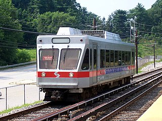
The Norristown High Speed Line is a 13.4-mile (21.6 km) interurban light rapid transit line operated by SEPTA, running between the 69th Street Transportation Center in Upper Darby and the Norristown Transportation Center in Norristown, Pennsylvania. Originally the Philadelphia and Western Railroad line, the line runs entirely on its own right-of-way. By 2020, the Norristown High Speed Line had an average weekday ridership approaching 11,000 passengers.

The B Line is a fully underground 14.7 mi (23.7 km) rapid transit line operating in Los Angeles, running between North Hollywood and Downtown Los Angeles. It is one of six lines in the Los Angeles Metro Rail system, operated by the Los Angeles County Metropolitan Transportation Authority. Built in four stages between 1986 and 2000, the line cost $4.5 billion.

1 Street SW Station is a stop in Downtown Calgary on the city's C-Train light rail system. The 1 Street platform is served by westbound trains only, with the nearest eastbound train platforms being Centre Street station and 3 Street SW station, both of which only serve eastbound trains. The platform is located on the north side of 7 Avenue South, west of Centre Street within the free fare zone, serving both routes 201 and 202.

The Alvarado Transportation Center (ATC) is a multimodal transit hub located at 100 1st Street SW in Downtown Albuquerque, New Mexico. The complex was built as a hub for Albuquerque's regional transit system and as a replacement for Albuquerque's previous bus depot and train station. The center serves ABQ RIDE, Amtrak, Greyhound Lines, and the New Mexico Rail Runner Express commuter rail line.

The Baltimore Light RailLink is a light rail system serving Baltimore, Maryland, United States, and its northern and southern suburbs. It is operated by the Maryland Transit Administration. In downtown Baltimore, it uses city streets. Outside the central portions of the city, the line is built on private rights-of-way, mostly from the defunct Northern Central Railway, Baltimore and Annapolis Railroad and Washington, Baltimore and Annapolis Electric Railway. The system had a ridership of 3,546,300, or about 14,400 per weekday, as of the first quarter of 2024.

Edmonton Light Rail Transit, commonly referred to as the LRT, is a light rail system in Edmonton, Alberta. Part of the Edmonton Transit Service (ETS), the system has 29 stations on three lines and 37.4 km (23.2 mi) of track. As of 2018, it was number seven on a list of the busiest light rail transit systems in North America, with over 113,000 daily weekday riders.

The Loop is the 1.79-mile-long (2.88 km) circuit of elevated rail that forms the hub of the Chicago "L" system in the United States. As of 2022, the branch served 31,893 passengers every weekday. The Loop is so named because the elevated tracks loop around a rectangle formed by Lake Street, Wabash Avenue (east), Van Buren Street (south), and Wells Street (west). The railway loop has given its name to Chicago's downtown, which is also known as the Loop.
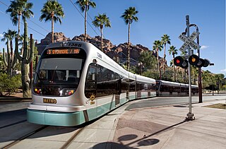
Valley Metro Rail is a 29.8-mile (48 km) light rail system serving the cities of Phoenix, Tempe, and Mesa in Arizona, USA. The network, which is part of the Valley Metro public transit system, began operations on December 27, 2008. In 2023, the system had a ridership of 10,797,600, or about 34,400 per weekday as of the first quarter of 2024.

The Metro Red Line is a bus rapid transit line between the Twin Cities suburbs of Bloomington, Minnesota and Apple Valley, Minnesota. The Red Line travels primarily on Minnesota State Highway 77 and Cedar Avenue from the Apple Valley station in Apple Valley, north through Eagan, Minnesota, to the Mall of America station in Bloomington where it connects to the Metro Blue Line. The line has bus rapid transit elements including bus-only lanes, specially branded vehicles, transit signal priority, and dedicated stations.

The Metro Orange Line is a bus rapid transit line in the Twin Cities, Minnesota operated by Metro Transit. The line operates primarily along Interstate 35W from downtown Minneapolis through Richfield and Bloomington before terminating in Burnsville, Minnesota. The Orange Line provides access to 198,000 jobs with roughly a quarter of them outside downtown Minneapolis. The route serves a mix of stations located in the center of the highway, stations near highway exits, and on-street stations. The line has features typical of bus rapid transit systems with off-board fare payment, articulated buses with extra doors, stations with improved passenger amenities, and transit-only bus lanes on portions of the route.

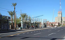
Jefferson/1st Avenue station and Washington/Central Avenue station, also collectively known as Downtown Phoenix and City Hall, is a pair of light rail stations on the Valley Metro Rail in Phoenix, Arizona, United States. It is the sixteenth stop westbound and the thirteenth stop eastbound on the initial 20-mile (32 km) starter line. This station is split between two platforms, the northbound platform on Central Avenue at Washington Street and the southbound on 1st Avenue at Jefferson Street, approximately 800 feet (240 m) apart.

Veterans Way/College Ave, also known as the Tempe Transportation Center, is a regional transportation center on Valley Metro Rail in Tempe, Arizona, United States. As part of the regional transportation system, it is also the location of stops on multiple bus routes. A bike station is located here.

Mount Baker station is a light rail station located in Seattle, Washington. It is situated between the Columbia City and Beacon Hill stations on the 1 Line, which runs from Seattle–Tacoma International Airport to Downtown Seattle, the University of Washington, and Northgate as part of the Link light rail system. The elevated station consists of two side platforms located west of the intersection of Rainier Avenue and Martin Luther King Jr. Way in the Mount Baker neighborhood, part of Seattle's Rainier Valley.

The J Line is a 38-mile (61.2 km) bus rapid transit line that runs between El Monte, Downtown Los Angeles and the Harbor Gateway, with some trips continuing to San Pedro. It is one of the two lines in the Metro Busway system operated by the Los Angeles County Metropolitan Transportation Authority (Metro).

Valley Metro Bus is a transit bus system for public transport in Maricopa County, Arizona, United States. In 2023, the system had a ridership of 24,215,700, or about 83,300 per weekday as of the first quarter of 2024. Buses are operated by private companies contracted by Valley Metro and the City of Phoenix. Service currently operates throughout the broader Phoenix Metropolitan Area. All buses have wheelchair ramps or lifts, and except for paratransit vehicles, all buses have bike racks.

Metro is a transit network in Minnesota serving the cities of Minneapolis and Saint Paul. It also provides service to some suburban areas. As of 2022, the system consists of two light rail lines and five bus rapid transit (BRT) lines all of which are operated by the local public transit company: Metro Transit. The five lines connect Downtown Minneapolis and St Paul with the Bloomington, Minneapolis-St Paul International Airport, Roseville, Richfield, Burnsville and Brooklyn Center.

Marshfield was a rapid transit station on the Chicago "L" in service between 1895 and 1954. Constructed by the Metropolitan West Side Elevated Railroad, it was the westernmost station of the Metropolitan's main line, which then diverged into three branches. Marshfield was also served by the Aurora Elgin and Chicago Railway (AE&C) and its descendant the Chicago Aurora and Elgin Railroad (CA&E), an interurban, between 1905 and 1953.