Venetian Isles, New Orleans

Last updated

Venetian Isles (French : Îles Vénetiennes) is a neighborhood of New Orleans, Louisiana. [1] It is located on the western shore of the Chef Menteur Pass on the northern side of U.S. Highway 90.

French language Romance language

French is a Romance language of the Indo-European family. It descended from the Vulgar Latin of the Roman Empire, as did all Romance languages. French evolved from Gallo-Romance, the spoken Latin in Gaul, and more specifically in Northern Gaul. Its closest relatives are the other langues d'oïl—languages historically spoken in northern France and in southern Belgium, which French (Francien) has largely supplanted. French was also influenced by native Celtic languages of Northern Roman Gaul like Gallia Belgica and by the (Germanic) Frankish language of the post-Roman Frankish invaders. Today, owing to France's past overseas expansion, there are numerous French-based creole languages, most notably Haitian Creole. A French-speaking person or nation may be referred to as Francophone in both English and French.

Chef Menteur Pass

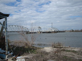
The Chef Menteur Pass is a narrow natural waterway which, along with the Rigolets, connects Lake Pontchartrain and Lake Borgne in New Orleans, Louisiana. It begins at 30°5′45″N89°48′52″W and follows a generally southeastward course.

U.S. Route 90 highway in the United States

U.S. Route 90 is an east–west United States highway. Despite the "0" in its route number, US 90 never was a full coast-to-coast route; it has always ended at Van Horn, Texas with the exception of a short-lived northward extension to US 62/US 180 near Pine Springs, Texas which lasted less than a year, and the signs on that segment were changed to Texas State Highway 54, traveling from Interstate 10 (I-10) at exit 140A and heading to its northern terminus at US 62/US 180.

Venetian Isles sign on Highway 90 VenetianIslesWelcomeSign.jpg
Venetian Isles sign on Highway 90

Legally a part of the city, Venetian Isles is separated from the bulk of the developed portion of the city by miles of undeveloped land. It long had the appearance of a small fishing town. In the late 20th century it saw development as a suburban style bedroom community.

City Large and permanent human settlement

A city is a large human settlement. Cities generally have extensive systems for housing, transportation, sanitation, utilities, land use, and communication. Their density facilitates interaction between people, government organizations and businesses, sometimes benefiting different parties in the process.

Suburb Human settlement that is part of or near to a larger city

A suburb is a mixed-use or residential area, existing either as part of a city or urban area or as a separate residential community within commuting distance of a city. In most English-speaking countries, suburban areas are defined in contrast to central or inner-city areas, but in Australian English and South African English, suburb has become largely synonymous with what is called a "neighborhood" in other countries and the term extends to inner-city areas. In some areas, such as Australia, India, China, New Zealand, the United Kingdom, and a few U.S. states, new suburbs are routinely annexed by adjacent cities. In others, such as Saudi Arabia, Canada, France, and much of the United States, many suburbs remain separate municipalities or are governed as part of a larger local government area such as a county.

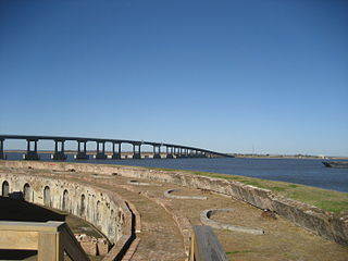
The ruins of old Fort Macomb are along Chef Menteur Pass at the south of the neighborhood.

Fort Macomb

Fort Macomb is a 19th-century United States brick fort in Louisiana, on the western shore of Chef Menteur Pass. It is listed on the National Register of Historic Places. The fort is adjacent to the Venetian Isles community, now legally within the city limits of New Orleans, Louisiana. This community was some miles distant from the city when first built and is still distant from the main developed portion of the city.

Venetian Isles was hit hard by storm surge during Hurricane Katrina in 2005. [2] As it lies outside of the City's levee system, [3] it experienced damage similar to that seen in Pearlington, Mississippi and Pass Christian.

A storm surge, storm flood, tidal surge or storm tide is a coastal flood or tsunami-like phenomenon of rising water commonly associated with low pressure weather systems, the severity of which is affected by the shallowness and orientation of the water body relative to storm path, as well as the timing of tides. Most casualties during tropical cyclones occur as the result of storm surges. It is a measure of the rise of water beyond what would be expected by the normal movement related to tides.

Hurricane Katrina Category 5 Atlantic hurricane in 2005

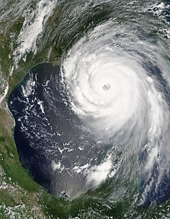
Hurricane Katrina was an extremely destructive and deadly Category 5 hurricane that made landfall on Florida and Louisiana, particularly the city of New Orleans and the surrounding areas, in August 2005, causing catastrophic damage from central Florida to eastern Texas. Subsequent flooding, caused largely as a result of fatal engineering flaws in the flood protection system known as levees around the city of New Orleans, precipitated most of the loss of lives. The storm was the third major hurricane of the record-breaking 2005 Atlantic hurricane season, as well as the fourth-most intense Atlantic hurricane on record to make landfall in the United States, behind only the 1935 Labor Day hurricane, Hurricane Camille in 1969, and Hurricane Michael in 2018.

Pearlington, Mississippi CDP in Mississippi, United States

Pearlington is a census-designated place (CDP) in Hancock County, Mississippi, United States, on U.S. Route 90, along the Pearl River, at the Louisiana state line. It is part of the Gulfport–Biloxi, Mississippi Metropolitan Statistical Area. The population was 1,684 at the 2000 census. On August 29, 2005, Hurricane Katrina made landfall just south of Pearlington.

Former 2nd District Congressman Joseph Cao makes his home in Venetian Isles.

Louisianas 2nd congressional district

Louisiana's 2nd congressional district is a congressional district in the U.S. state of Louisiana. The district contains nearly all of the city of New Orleans and stretches west and north to Baton Rouge.

Joseph Cao Vietnamese-American activist and politician

Ánh Quang "Joseph" Cao is a Vietnamese-American politician who was the U.S. Representative for Louisiana's 2nd congressional district from 2009 to 2011. He is a member of the Republican Party. In April 2011, Cao announced his candidacy for the office of Attorney General of Louisiana, but in September 2011 he pulled out of the race. The incumbent Buddy Caldwell ran unopposed for a second term.

Related Research Articles

New Orleans Regional Transit Authority public transit operator in New Orleans, Louisiana

The New Orleans Regional Transit Authority is a public transportation agency based in New Orleans. The agency was established by the Louisiana State Legislature in 1979, and has operated bus and historic streetcar service throughout the city since 1983. With an annual ridership of over 18.6 million riders, the Regional Transit Authority is the largest public transit agency in the state of Louisiana.

Lake Pontchartrain estuary located in southeastern Louisiana, United States

Lake Pontchartrain is a brackish estuary located in southeastern Louisiana in the United States. It covers an area of 630 square miles (1,600 km2) with an average depth of 12 to 14 feet. Some shipping channels are kept deeper through dredging. It is roughly oval in shape, about 40 miles (64 km) from west to east and 24 miles (39 km) from south to north.

9th Ward of New Orleans human settlement in United States of America

The Ninth Ward or 9th Ward is a distinctive region of New Orleans, Louisiana, which is located in the easternmost downriver portion of the city. It is geographically the largest of the 17 Wards of New Orleans. On the south, the Ninth Ward is bounded by the Mississippi River. On the western or "upriver" side, the Ninth Ward is bounded by Franklin Avenue, then Almonaster Avenue, then People's Avenue. From the north end of People's Avenue the boundary continues on a straight line north to Lake Pontchartrain; this line is the boundary between the Ninth and the city's Eighth Ward. The Lake forms the north and northeastern end of the ward. St. Bernard Parish is the boundary to the southeast, Lake Borgne farther southeast and east, and the end of Orleans Parish to the east at the Rigolets.

Lake St. Catherine is a brackish-water lake that is located in eastern Orleans Parish, within the city limits of New Orleans, between Lake Pontchartrain and Lake Borgne in Louisiana. Between Lake St. Catherine and Lake Borgne was the original Town of Lake Catherine. Established between Unknown Pass and Miller's Ditch, it was settled for railroad workers, trappers, hunters and fishermen.

Industrial Canal canal in Louisiana, United States of America

The Industrial Canal is a 5.5 mile (9 km) waterway in New Orleans, Louisiana, United States. The waterway's proper name, as used by the U.S. Army Corps of Engineers and on NOAA nautical charts, is Inner Harbor Navigation Canal (IHNC). The more common "Industrial Canal" name is used locally, both by commercial mariners and by landside residents.

In 1980 the New Orleans City Planning Commission divided the city into 13 planning districts and 72 distinct neighborhoods. See Orleans Parish neighborhood map

Gentilly, New Orleans New Orleans neighborhood in Louisiana, United States

Gentilly is a broad, predominantly middle-class and racially diverse section of New Orleans, Louisiana. The Gentilly neighborhood is bounded by Lake Pontchartrain to the north, France Road to the east, Bayou St. John to the west, and the Louisville and Nashville Railroad to the south.

Eastern New Orleans human settlement in New Orleans, Louisiana, United States of America

The eastern section of New Orleans, colloquially known as "New Orleans East," is a large section of that city. Developed extensively from the 1960s forward, its numerous residential subdivisions and shopping centers offered suburban-style living within the city. But, despite its location within New Orleans' city limits, its character remained suburban, resembling the typically sprawling American suburbia much more than the compactly built environment found in the city's historic core.

U.S. Route 90 in Louisiana highway in Louisiana

U.S. Highway 90 in Louisiana , one of the major east–west U.S. Highways in the Southern United States, runs through southern Louisiana for 297.6 miles (478.9 km), serving Lake Charles, Lafayette, New Iberia, Morgan City, and New Orleans. Much of it west of Lafayette and east of New Orleans has been supplanted by Interstate 10 (I-10) for all but local traffic, but the section between Lafayette and New Orleans runs a good deal south of I-10.

Fort Pike Bridge bridge in United States of America

The Fort Pike Bridge carries U.S. Route 90 across the Rigolets on the eastern side of Lake Pontchartrain between New Orleans and Slidell in Louisiana. The bridge opened on June 9, 1930, and along with the Chef Menteur Bridge provided a free route between New Orleans and the Mississippi Gulf Coast. This was the site of Jayne Mansfield's death in June 1967. A new span was constructed just to the north of the old span.

The Maestri Bridge carries U.S. Route 11 (US 11) across Lake Pontchartrain between New Orleans and Slidell, Louisiana, in the United States.

Chef Menteur Bridge bridge in United States of America

The Chef Menteur Bridge is a bridge which connects between New Orleans and Slidell, Louisiana. It carries U.S. Route 90 (US 90) across Chef Menteur Pass on the eastern side of Lake Pontchartrain.

Desire Area, New Orleans CDP in Louisiana, United States

Desire Area is a neighborhood of the city of New Orleans. A subdistrict of the Bywater District Area, its boundaries as defined by the City Planning Commission are: Gentilly Boulevard to the north; the Industrial Canal to the east; Florida Boulevard, Alvar Street, Higgins Boulevard, Piety Street, Pleasure Street, Oliver White Avenue, and Desire Street to the south; and People's Avenue to the west. It is part of the Upper 9th Ward.

Pines Village is a neighborhood in the city of New Orleans, Louisiana, United States. A subdistrict of the New Orleans East area, its boundaries as defined by the City Planning Commission are: Downman Road and Interstate 10 to the east, Chef Menteur Highway to the south, Lake Pontchartrain and Morrison Road to the north, and the Industrial Canal to the west.

Dong Phuong Oriental Bakery Vietnamese bakery and restaurant in New Orleans, Louisiana, United STates

Dong Phuong Oriental Bakery is a Vietnamese retail and wholesale bakery, restaurant, and catering business in New Orleans, Louisiana. It is known for supplying the baguette style bread for many of the city's restaurants that offer banh mi or other sandwiches, and has its own popular banh mi counter. The bakery, along with the nearby Mary Queen of Vietnam Catholic Church, were fixtures of the Vietnamese community in New Orleans even before surviving the devastation of Hurricane Katrina. It is located at 14207 Chef Menteur Highway in the "Little Vietnam" section of Eastern New Orleans. It is attached to a sit-down restaurant of the same name that serves a variety of Vietnamese and Chinese dishes, including phở, bún thịt nướng, bún riêu, and bánh hỏi.

The CSX Chef Menteur Pass Bridge carries one track of CSX rail lines across the Chef Menteur Pass on the eastern side of Lake Pontchartrain between New Orleans and Slidell, Louisiana.

References