Vermont-Slauson, Los Angeles

Last updated
Vermont-Slauson
Neighborhood of Los Angeles
Country United States
State California
County Los Angeles
City Los Angeles
Time zone PST

The Vermont-Slauson district of Los Angeles is a 1.44-square-mile neighborhood within the South Los Angeles region of Los Angeles, California.

South Los Angeles districts and neighborhoods of Los Angeles

South Los Angeles is a region in southern Los Angeles County, California, and mostly lies within the city limits of Los Angeles, just south of downtown.

Contents

Geography

Vermont-Slauson district of the city of Los Angeles, as drawn by the Los Angeles Times Map of Vermont-Slauson neighborhood of Los Angeles California.jpg
Vermont-Slauson district of the city of Los Angeles, as drawn by the Los Angeles Times

The Vermont-Slauson neighborhood touches Vermont Square on the north, Florence on the east, Vermont Knolls on the south and Harvard Park on the west. [1] It is bounded by 54th Street on the north, the Interstate 110 Freeway on the east, Florence Avenue on the south and Western Avenue on the west. [2]

Vermont Square, Los Angeles Neighborhood of Los Angeles in California, United States

Vermont Square is a neighborhood in Los Angeles, California, within the South Los Angeles region. The Vermont Square Branch library, a designated Historic-Cultural Monument, is located in the community.

Florence, Los Angeles Neighborhood of Los Angeles in Los Angeles, California, United States

Florence is a neighborhood in Los Angeles, California. The neighborhood, part of the South Los Angeles region, is home to over 46,000 residents.

Vermont Knolls, Los Angeles Neighborhood of Los Angeles in California, United States

Vermont Knolls is a neighborhood in Los Angeles, California, United States, within the South Los Angeles region.

Demographics

It is notable within the city for its high density of population, its relatively mid to low household income, its youthful population, its high average household size and the percentage of its families headed by single parents. [2]

A total of 26,797 residents lived in Vermont-Slauson's 1,44 square miles, according to the 2000 U.S. census — averaging 18,577 people per square mile, among the highest population densities in both the city and the county. [2]

Population density A measurement of population numbers per unit area or volume

Population density is a measurement of population per unit area or unit volume; it is a quantity of type number density. It is frequently applied to living organisms, and most of the time to humans. It is a key geographical term. In simple terms population density refers to the number of people living in an area per kilometer square.

The median age was 25, young for the city and the county, and the percentages of residents younger than age 18 were among the county's highest. There were 1,370 families headed by single parents; the rate of 24.8% was considered high for both the city and the county. [2]

Within the neighborhood, Latino made up 60.5% of the population, while African American were 36.8%. Other ethnicities are White 2.3%; Asian, 0.3%; and other, 1%. Mexico and El Salvador were the most common places of birth for the 39.2% of the residents who were born abroad, about an average percentage for the city as a whole. [2]

Hispanic Americans and Latino Americans are Americans who are descendants of people from Spain and Latin America. More generally, it includes all Americans who self-identify as Hispanic or Latino, whether of full or partial ancestry. For the 2010 United States Census, people counted as "Hispanic" or "Latino" were those who identified as one of the specific Hispanic or Latino categories listed on the census questionnaire as well as those who indicated that they were "other Spanish, Hispanic or Latino." The national origins classified as Hispanic or Latino by the United States Census Bureau are the following: Argentine, Cuban, Colombian, Puerto Rican, Dominican, Mexican, Costa Rican, Guatemalan, Honduran, Nicaraguan, Panamanian, Salvadoran, Bolivian, Spanish American, Chilean, Ecuadorian, Paraguayan, Peruvian, Uruguayan and Venezuelan. Brazilian Americans and other Portuguese-speaking Latino groups in the United States are solely defined as "Latino" by some U.S. government agencies. The Census Bureau uses the terms Hispanic and Latino interchangeably.

White people is a racial classification specifier, used mostly and often exclusively for people of European descent; depending on context, nationality, and point of view. The term has at times been expanded to encompass persons of Middle Eastern and North African descent, persons who are often considered non-white in other contexts. The usage of "white people" or a "white race" as nomenclature for European populations - indicated by their light skin, among other physical characteristics, and contrasting with "black people", Amerindians, and other "colored" people or "persons of color" - originated in the 17th century. It was only during the 19th century that the category of white people was transformed in a quasi-scientific system of race and skin color relations. The term "Caucasian" is sometimes used as a synonym for "white" in its racial sense and sometimes to refer to a larger racial category that includes white people among other groups.

The median household income in 2008 dollars was $31,236, considered low for both the city and county. The percentage of households earning $20,000 or less was high, compared to the county at large. The average household size of 3.5 people was also considered high. Renters occupied 61.5% of the housing units, and homeowners occupied the rest. [2]

Recreation and parks

Education

Only 3.7% of Vermont-Slauson residents 25 and older held a four-year degree, a low percentage for both the city and the county. The percentage of residents age 25 and older with less than a high school diploma was high for the county. [2]

Schools within the boundaries of Vermont-Slauson are: [4]

Related Research Articles

Mar Vista, Los Angeles Neighborhood of Los Angeles

Mar Vista is a residential and commercial neighborhood on the Westside of Los Angeles, California. It is the home of Venice High School, two private schools, a branch public library and a city park.

Pico-Union, Los Angeles Neighborhood of Los Angeles in California, United States of America

Pico-Union is a neighborhood in Central Los Angeles, California. The name "Pico-Union" refers to the neighborhood that surrounds the intersection of Pico Boulevard and Union Avenue. Located immediately west of Downtown Los Angeles, it is home to over 40,000 residents.

West Adams, Los Angeles Neighborhood of Los Angeles in California, United States

West Adams is a historic neighborhood in the South Los Angeles region of Los Angeles, California. The area is known for its large number of historic buildings, structures and notable houses and mansions throughout Los Angeles. It is a youthful, densely populated area with a high percentage of African American and Latino residents. The neighborhood has several public and private schools.

South Park, Los Angeles district in Los Angeles

South Park is a 1.41 square miles (3.65 km2) neighborhood within the South Los Angeles region of Los Angeles, California.

Hyde Park, Los Angeles Neighborhood of Los Angeles in California, United States

Hyde Park is a neighborhood in the West region of Los Angeles, California. Formerly a separate city, it was incorporated into Los Angeles in 1923.

University Park, Los Angeles Neighborhood of Los Angeles in California, United States

University Park is a 1.17 square miles (3.0 km2) neighborhood in the South Los Angeles region of Los Angeles, California. It is the home of the University of Southern California (USC), Mount St. Mary's College and Hebrew Union College. Additionally, the neighborhood is the home of the historic Shrine Auditorium.

Chesterfield Square, Los Angeles Neighborhood of Los Angeles in California, United States

Chesterfield Square is a 0.63-square-mile neighborhood in Los Angeles, California, located within the South Los Angeles region. It contains its namesake park, along with the Van Ness Recreation Center.

Historic South Central Los Angeles Neighborhood of Los Angeles in California, United States

Historic South Central Los Angeles is a 2.25-square-mile neighborhood in Los Angeles, California, within the South Los Angeles region. It is the site of the Bob Hope Patriotic Hall. From the late 1800s to early 1910s, African Americans began relocating to the area, mostly organizing around landholdings of Los Angeles pioneer Biddy Mason. The African American population continued to grow into the 1940s, and countless Jazz nightclubs lined South Central Avenue. In the 1990s, the neighborhood shifted to becoming a hub for Latino immigrants, with many being drawn by low rents and central City location. Also with the addition of the Metro Blue Line on the Washington Boulevard corridor has spurred growth, and a community plan recently adopted by the L.A. City Council hopes to revitalize the neighborhood.

Harbor City, Los Angeles Neighborhood of Los Angeles

Harbor City is a highly diverse neighborhood within the Los Angeles Harbor Region of Los Angeles, California, with a population upward of 36,000 people. Originally part of the Rancho San Pedro Spanish land grant, the 2.58-square-mile Harbor City was brought into Los Angeles as a preliminary step in the larger city's consolidation with the port cities of Wilmington and San Pedro.

Manchester Square, Los Angeles Neighborhood of Los Angeles in California, United States

Manchester Square is a neighborhood in Los Angeles, California, within the South Los Angeles region.

Gramercy Park, Los Angeles Neighborhood of Los Angeles in California, United States

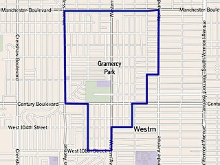
Gramercy Park is a neighborhood in Los Angeles, California, within the South Los Angeles region. It has a population of at least 11,000. Jesse Owens Community Regional Park is located in the neighborhood.

Broadway-Manchester, Los Angeles Neighborhood of Los Angeles in Los Angeles, California, United States

Broadway-Manchester is a 1.5-square-mile neighborhood in Los Angeles, California. The neighborhood, part of the South Los Angeles area, is home to over 23,000 residents.

Green Meadows, Los Angeles Neighborhood of Los Angeles in Los Angeles, California, United States

The Green Meadows district of Los Angeles is a 2.22-square-mile neighborhood in Los Angeles, California with a population of more than thirty thousand people. Green Meadows is within the South Los Angeles region and is the home of Locke College Preparatory Academy.

Harvard Park, Los Angeles Neighborhood of Los Angeles in Los Angeles, California, United States of America

Harvard Park is a 0.64-square-mile neighborhood in the South Los Angeles region of Los Angeles, California. It is centered on a municipal park by that name.

Adams-Normandie, Los Angeles districts and neighborhoods of Los Angeles

The Adams-Normandie neighborhood of Los Angeles is a neighborhood within the South Los Angeles region of Los Angeles, California. It is notable within the city for its high density of population, its relatively low household income, its youthful population, its high average household size, the high percentage of its families headed by single parents and the high percentage of residents born outside the United States.

Exposition Park, Los Angeles Neighborhood of Los Angeles in California, United States

The Exposition Park neighborhood of Los Angeles is in the south region of Los Angeles, California. It is home to Exposition Park, which includes the Los Angeles Memorial Coliseum, Banc of California Stadium, Exposition Rose Garden and three museums: the California African American Museum, the California Science Center and the Natural History Museum of Los Angeles County. It is also home to a Science Center Academy.

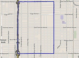
Vermont Vista is a 1.65-square-mile, low-income neighborhood located in South Los Angeles of Los Angeles, California. It is notable for its dense concentration of residents, their youthful age range, their high ratio of single to married parents, their low rate of marriage and their low median household income.

References

Coordinates: 33°59′20″N118°17′29″W / 33.988995°N 118.291492°W / 33.988995; -118.291492