This article does not cite any sources .(June 2016) (Learn how and when to remove this template message) |


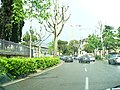
The Viali di Circonvallazione are a series of 6-lane boulevards surrounding the north part of the historic centre of Florence.
This article does not cite any sources .(June 2016) (Learn how and when to remove this template message) |
The Viali di Circonvallazione are a series of 6-lane boulevards surrounding the north part of the historic centre of Florence.
The boulevards follow the outline of the ancient walls of Florence, that were demolished in 1865 according to Giuseppe Poggi's project to make Florence, then the capital of Italy, a modern city with wide boulevards inspired by those of Paris. Around the former gates of the city, squares and palaces were created.
Today the viali di Circonvallazione are the main arterial street of Florence for the traffic from west to east.
The route (from west) starting from Ponte alla Vittoria bridge is:


| | This Italian road or road transport-related article is a stub. You can help Wikipedia by expanding it. |

Esquilino is the 15th rione of Rome, identified by the initials R. XV, and is Located within the Municipio I. It is named after the Esquiline Hill, one of the Seven Hills of Rome.

San Saba is the 21st rione of Rome, identified by the initials R. XXI. It is located within the Municipio I, and takes its name from the Basilica of San Saba, which is located there.

Actv S.p.A. is a public company responsible for public transportation in Venice and Chioggia municipalities and for interurban bus services in province of Venice. ACTV is not responsible for Venice People Mover and waterbus routes between airport and the lagoon area. Connections by bus with Venice airport are managed by ACTV and by ATVO.

Piazza della Repubblica is a city square in Florence, Italy. It was originally the site of the city's forum; then of its old ghetto, which was swept away during the improvement works, or Risanamento, initiated during the brief period when Florence was the capital of a reunited Italy—work that also created the city's avenues and boulevards. At that time, the Loggia del Pesce from the Mercato Vecchio was also moved to Piazza Ciompi. The square's Giubbe Rosse cafe has long been a meeting place for famous artists and writers, notably those of Futurism.
Piazzale Michelangelo is a square with a panoramic view of Florence, Italy, located in the Oltrarno district of the city.

The historic centre of Florence is part of quartiere 1 of the Italian city of Florence. This quarter was named a World Heritage Site by UNESCO in 1982.

Piazza della Libertà is the northernmost point of the historic centre of Florence. It was created in the 19th century during works to produce the Viali di Circonvallazione around the city. It hosts Triumphal Arch of the Lorraine and, in winter, an ice rink for skating.

Monte Sacro is the 16th quartiere of the city of Rome in Italy. As a quarter, or second level administrative division, it is one of two that comprise the first level division of Municipio III.

Piazza del Duomo is located in the heart of the historic center of Florence. It is one of the most visited places in Europe and the world and in Florence, the most visited area of the city. The square contains the Florence Cathedral with the Cupola del Brunelleschi, the Giotto's Campanile, the Florence Baptistery, the Loggia del Bigallo, the Opera del Duomo Museum, and the Arcivescovile and Canonici's palace. The west zone of this square is called Piazza San Giovanni.

Piazza Cesare Beccaria is a square of Florence located on the viali di Circonvallazione, the boulevard along the route of the former walls of Florence.

Porta Vittoria was a city gate in the Spanish walls of Milan, Italy. While the walls and the gate have been demolished, the name "Porta Vittoria" has remained to refer to the district ("quartiere") where the gate used to be. This district is part of the Zone 4 administrative division of Milan.

Giuseppe Poggi was an Italian architect, mainly active in Tuscany.

Via Cristoforo Colombo is a street in Rome (Italy) that links the historic centre to Ostia. Along most of its route, the street has three lanes for each direction of movement. With its 27 kilometres (17 mi) length it is the longest Italian road among those included within the borders of a single municipality and, in several stretches, the largest in Italy.

Ostiense is the 10th quartiere of Rome, identified by the initials Q. X.
The city Milan, Italy, has had three different systems of defending walls. The oldest, Roman walls were developed in two stages, the first in the Republican and the second in the Imperial era. The second wall system was realized in the Middle Ages, after the destruction of the city by Frederick I Barbarossa. Finally, the latest wall system was built by the Spanish rulers. While very little remains of these walls, their structure is clearly reflected in the urbanistic layout of the city. In particular, modern Milan has two roughly circular rings of streets, namely the "Cerchia dei Navigli" and the "Cerchia dei Bastioni", which essentially correspond to the Medieval and Spanish walls, respectively. Note that a third ring of roads just beyond the Inner Ring Road, called the External Ring Road, does not owe itself to any old city walls; but was part of the 1884 Beruto Plan for the city of Milan, created and named after a municipal engineer and public servant to the local city government.

Viale Pasubio is an avenue in Milan, Italy. It is part of the circonvallazione interna ring road, a major traffic route that runs along the former Spanish walls of Milan. The street is 350 m long and connects two former city gates, namely Porta Garibaldi and Porta Volta. The street was formerly known as "Viale di Porta Garibaldi", and was renamed after World War I in remembrance of the fightings on the Pasubio massif (Dolomites) that occurred during the war.
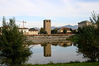
The Torre della Zecca is a tower in the city walls of Florence, closing the city off from the river Arno to the east and thus known as a "torre terminale". It is now isolated in the middle of a junction on the viali di Circonvallazione in piazza Piave, near the lungarno della Zecca Vecchia.

Piazza Piave is a square on the viali di Circonvallazione in Florence, Italy. It marks the eastern boundary of the historic city centre on the north bank of the river Arno. At its centre is the Torre della Zecca Vecchia. It marks the junction between five traffic arteries - the Lungarno della Zecca Vecchia, the Lungarno Pecori Giraldi, the viale della Giovine Italia, via dei Malcontenti and via Tripoli. Inside the city wall, at the junction between via Tripoli and via via dei Malcontenti, the square widens - this space is recorded on the carta del Buonsignori (1565) as the "Sepolture dei Giudei" or Jewish Cemetery. It was known as the Piazza della Zecca Vecchia until 1919, when it was renamed in honour of the Battle of Piave River.

Flaminio is the 1st quartiere of the Italian capital Rome. Identified by the initials Q. I, it belongs to the Municipio II and has 13,018 inhabitants and an area of 1.1877 km². The name is derived from the Via Flaminia.