
Springfield is the capital of the U.S. state of Illinois and the county seat of Sangamon County. The city's population of 116,250 as of the 2010 U.S. Census makes it the state's sixth most populous city. It is the largest city in central Illinois. As of 2013, the city's population was estimated to have increased to 117,006, with just over 211,700 residents living in the Springfield Metropolitan Statistical Area, which includes Sangamon County and the adjacent Menard County.
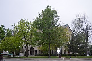
Taylorville is a city in and the county seat of Christian County, Illinois, United States. The population was 11,427 at the 2000 census, making it the county's largest city.
Harristown is a village in Macon County, Illinois, United States whose population was 1,358 at the 2012 census. It is included in the Decatur, Illinois Metropolitan Statistical Area.

Glen Carbon is a village in Madison County, Illinois, United States, 19 miles (31 km) northeast of St. Louis. The population was 12,934 at the 2010 census.

Chatham is a village in Sangamon County, Illinois, United States. It is located 2.8 miles south of Springfield and has a retail trade area that extends into four other municipalities, including Springfield. The population was 11,500 as of the 2010 census and estimated to be 11,946 as of 2012. The village lies along the original alignment of historic U.S. Route 66.

Sherman is a village in Sangamon County, Illinois, United States. The population was 4,148 at the 2010 census. It is part of the Springfield, Illinois Metropolitan Statistical Area.

Wabash is a city in Noble Township, Wabash County, in the U.S. state of Indiana. The population was 10,666 at the 2010 census. The city is the county seat of Wabash County.

The Embarras River is a 195-mile-long (314 km) tributary of the Wabash River in southeastern Illinois in the United States. The waters of the Embarras reach the Gulf of Mexico via the Wabash, Ohio, and Mississippi Rivers. The river drains a watershed around 1,566,450 acres (6,339.2 km2) in an agricultural region. The name comes from French explorers, who used the term embarras for river obstacles, blockages, and difficulties relating to logjams and the like.
The Lost Bridge Trail is a 5.0-mile (8.0 km) rail trail in Sangamon County, Illinois. It was built by the Illinois Department of Transportation (IDOT) along an abandoned Baltimore and Ohio Railroad corridor between the east side of Springfield, Illinois to the center of Rochester, Illinois.

Rochester is a village in Sangamon County, Illinois, United States. The population was 2,893 at the 2000 census, and 3,246 at a 2009 estimate. The village was settled in 1819, and is located in Rochester Township.

Mount Auburn Township is one of seventeen townships in Christian County, Illinois, USA. As of the 2010 census, its population was 1,028 and it contained 458 housing units.

Carpenter Park is a 322-acre (1.3 km²) park on the north bank of the Sangamon River on the far north side of the city of Springfield, Illinois. Part of the park is a listed Illinois Nature Preserve and has been designated as an Important Bird Area of Illinois. The park, which is operated by the Springfield Park District, is one of the roadside attractions of old Route 66.
The Interurban Trail is a 4.75-mile (7.6 km) rail trail in Sangamon County, Illinois. It was built by the Illinois Department of Transportation (IDOT) and occupies an abandoned Illinois Terminal Railroad interurban corridor. It stretches from the south side of Springfield, Illinois, to the center of Chatham, Illinois.

Wabash Township is one of thirteen townships in Parke County, Indiana, United States. As of the 2010 census, its population was 818 and it contained 353 housing units.
The Sangamon Valley Trail is an 11.5-mile (18.5 km) rail trail on the west side of Sangamon County in the U.S. state of Illinois. Skirting Springfield, Illinois, it extends from Centennial Park, on Springfield's southwest side, to Irwin Bridge Road near Sangamon County's northern border. It was constructed by a Sangamon County team in two stages; the 5.5-mile-long first or southern stage was completed in 2010–2011 at a cost of $3.8 million, and opened to the public on July 26, 2011. The 6-mile-long second or northern half of the trail was completed in 2016-2017 at a cost of $4.4 million, and opened to the public on November 16, 2017. The trail is operated by the Springfield Park District.

The Wabash Railroad was a Class I railroad that operated in the mid-central United States. It served a large area, including track in the states of Ohio, Indiana, Illinois, Iowa, Michigan, and Missouri and the province of Ontario. Its primary connections included Chicago, Illinois; Kansas City, Missouri; Detroit, Michigan; Buffalo, New York; St. Louis, Missouri; and Toledo, Ohio.
Toronto was an unincorporated rural community located in Woodside Township, Sangamon County, Illinois. It was located adjacent to what is now the Toronto Road exit at Mile 90 of the Illinois section of Interstate 55. Today, the Toronto neighborhood of Springfield is roughly defined as the region bordering Lake Springfield south of Interstate 72 and east of Interstate 55.
The Springfield Park District, established in 1900, is the public park authority serving the metropolitan area of Springfield in the U.S. state of Illinois. The Springfield park district, which is separate from the municipal government of the city of Springfield, covers approximately 2,500 acres of open space. The park district has taxing power over about 60 square miles of Sangamon County; it operates 40 facilities that include four public golf courses. Facilities include the park district's flagship open space, Washington Park; an Illinois State Natural Area and Important Bird Area of Illinois, Carpenter Park; and the Americans with Disabilities Act-compliant Southwind Park.
The Edwin Watts Southwind Park, popularly known as Southwind Park, is an 80-acre (0.3 km²) park within the Springfield Park District in Springfield, Illinois. It describes itself as a national model park for the demonstration of compliance with the Americans with Disabilities Act (ADA) in the provision of accessibilities to persons with disabilities.


