
Camden County is a county located in the southeastern corner of the U.S. state of Georgia. According to the 2010 Census, the population was 50,513. Its county seat is Woodbine, and the largest city is St. Marys. It is one of the original counties of Georgia, created February 5, 1777. It is the 11th largest county in the state of Georgia by area, and the 41st largest by population.

St. Simons Island is a barrier island and census-designated place (CDP) located on St. Simons Island in Glynn County, Georgia, United States. The names of the community and the island are interchangeable, known simply as "St. Simons Island" or "SSI", or locally as "The Island". St. Simons is part of the Brunswick, Georgia Metropolitan Statistical Area, and according to the 2010 census, the CDP had a population of 12,743.

Darien is a city in McIntosh County, Georgia, United States. It lies on Georgia's coast at the mouth of the Altamaha River, approximately 50 miles south of Savannah, and is part of the Brunswick, Georgia Metropolitan Statistical Area. The population of Darien was 1,975 at the 2010 census. The city is the county seat of McIntosh County. It is the second oldest planned city in Georgia and was originally called New Inverness.
Button Gwinnett was a British-born American founding father who, as a representative of Georgia to the Continental Congress, was one of the signatories on the United States Declaration of Independence. He was also, briefly, the provisional president of Georgia in 1777, and Gwinnett County was named for him. Gwinnett was killed in a duel by rival Lachlan McIntosh following a dispute after a failed invasion of East Florida.
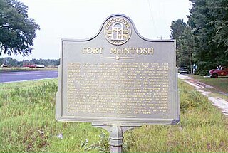
Fort McIntosh is an American military fortification from the American Revolution located near the Satilla River in Brantley County, Georgia, near the present site of the intersection of U.S. Route 82 and Georgia State Route 110 near the town of Atkinson, Georgia.
Sapelo Island is a state-protected barrier island located in McIntosh County, Georgia. The island is accessible only by aircraft or boat; the primary ferry comes from the Sapelo Island Visitors Center in McIntosh County, Georgia, a seven-mile (11 km), twenty-minute trip. It is the site of Hog Hammock, the last known Gullah community. It is illegal to visit the island without a permit issued by state tourism authorities.

The 5th Georgia Cavalry was a cavalry regiment in the Confederate States Army during the American Civil War. It was composed of enlistees from the state of Georgia and served entirely in the Western Theater.

US Coast Guard Air Station Sector Field Office Port Angeles is located at the end of the Ediz Hook peninsula in Port Angeles, Washington.
The Broro River is a 2.5-mile-long (4.0 km) tidal arm of the Sapelo River in McIntosh County, Georgia, in the United States.
The Crescent River is a 5.4-mile-long (8.7 km) tidal river in McIntosh County, Georgia, in the United States. It forms in salt marshes east of the community of Bellville Point and flows southeast, ending at a river junction where the Mud River flows northeast into Sapelo Sound and Old Teakettle Creek flows south to Doboy Sound.

The Duplin River is an 8.1-mile-long (13.0 km) tidal river in McIntosh County, Georgia, in the United States. It flows from north to south along the western edge of Sapelo Island into Doboy Sound, an arm of the Atlantic Ocean.
The Mud River is a 6.4-mile-long (10.3 km) tidal arm of the Sapelo River in McIntosh County, Georgia, in the United States. It forms the northern part of the channel separating Sapelo Island from the mainland.
The Sapelo River is a 23-mile-long (37 km) primarily tidal river in McIntosh County in the U.S. state of Georgia. It forms between Interstate 95 and U.S. Route 17 near the community of Eulonia and winds generally east through salt marshes into Sapelo Sound, an arm of the Atlantic Ocean that separates St. Catherines Island to the north from Sapelo Island to the south.
The South River is a 3.2-mile-long (5.1 km) tidal channel in McIntosh County, Georgia, in the United States. It connects the Darien River to its west with Doboy Sound, an arm of the Atlantic Ocean, to its east. It flows through an extensive saltmarsh complex, with Queens Island to the north and Wolf Island to the south.

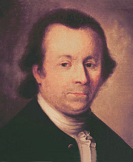
Lachlan McIntosh was a Scottish American military and political leader during the American Revolution and the early United States. In a 1777 duel, he fatally shot Button Gwinnett, a signer of the Declaration of Independence.
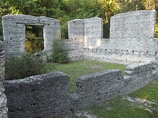
The McIntosh Sugarworks was built in the late 1820s by John Houstoun McIntosh. They are a significant example of tabby architecture and represent an industrial component of southeastern plantation agriculture. The Tabby Ruins, as they are also known, are located at 3600 Charlie Smith Sr. Highway at Georgia Spur 40, six miles north of St. Marys. The entrance is approximately across the street from the entrance to the Naval Submarine Base Kings Bay, on Charlie Smith Highway, at 30.79310°N 81.57712°W.
Black Island is a tidal island located just East of Darien, Georgia. It currently has a private gated residential community that is surrounded by native woodlands and marshes.
Creighton Island is a privately owned, barrier island in McIntosh County, Georgia. The island received its name from Alexander Creighton, a businessman from Savannah, Georgia, who owned the island in 1778.


