Washington's congressional districts

Last updated

Washington's congressional districts from 2023 WashCDSVG.svg
Washington's congressional districts from 2023

The following is a list of the ten congressional districts in the U.S. state of Washington. From the time that Washington Territory was formed in 1853, through statehood in 1889, Washington Territory elected an at-large non-voting Delegate to the United States House of Representatives. At different times in its history, the state of Washington has also elected one or more representatives At-large statewide. Washington gained its 10th district following reapportionment after the 2010 census.

Contents

Current districts and representatives

List of members of the United States House delegation from Washington, their terms, their district boundaries, and the district political ratings according to the CPVI. The delegation has a total of 10 members, including 8 Democrats and 2 Republicans.

Current U.S. representatives from Washington
DistrictMember
(Residence) [1]
PartyIncumbent since CPVI
(2022) [2]
District map
1st Suzan DelBene, official portrait, 115th Congress.jpg
Suzan DelBene
(Medina)
DemocraticNovember 13, 2012D+13 Washington's 1st congressional district (since 2023) (new version).svg
2nd Rick Larsen 116th Congress official photo.jpg
Rick Larsen
(Everett)
DemocraticJanuary 3, 2001D+9 Washington's 2nd congressional district (since 2023) (new version).svg
3rd Rep. Marie Gluesenkamp Perez - 118th Congress.jpg
Marie Gluesenkamp Perez
(Stevenson)
DemocraticJanuary 3, 2023R+5 Washington's 3rd congressional district (since 2023) (new version).svg
4th Dan Newhouse official congressional photo.jpg
Dan Newhouse
(Sunnyside)
RepublicanJanuary 3, 2015R+11 Washington's 4th congressional district (since 2023) (new version).svg
5th Cathy McMorris Rodgers official photo.jpg
Cathy McMorris Rodgers
(Spokane)
RepublicanJanuary 3, 2005R+8 Washington's 5th congressional district (since 2023) (new version).svg
6th Derek Kilmer 113th Congress.jpg
Derek Kilmer
(Gig Harbor)
DemocraticJanuary 3, 2013D+6 Washington's 6th congressional district (since 2023) (new version).svg
7th Pramila Jayapal, official portrait, 116th Congress (cropped).jpg
Pramila Jayapal
(Seattle)
DemocraticJanuary 3, 2017D+36 Washington's 7th congressional district (since 2023) (new version).svg
8th Kim Schrier, official portrait, 116th Congress.jpg
Kim Schrier
(Sammamish)
DemocraticJanuary 3, 2019D+1 Washington's 8th congressional district (since 2023) (new version).svg
9th Adam Smith official photo.jpg
Adam Smith
(Bellevue)
DemocraticJanuary 3, 1997D+21 Washington's 9th congressional district (since 2023) (new version).svg
10th Marilyn Strickland 117th U.S Congress.jpg
Marilyn Strickland
(Tacoma)
DemocraticJanuary 3, 2021D+7 Washington's 10th congressional district (since 2023) (new version).svg

Historical and present district boundaries

Table of United States congressional district boundary maps in the State of Washington, presented chronologically. [3] All redistricting events that took place in Washington between 1973 and 2013 are shown.

YearStatewide mapPuget Sound highlight
1973–1982 United States Congressional Districts in Washington, 1973 - 1982.tif United States Congressional Districts in Washington (metro highlight), 1973 - 1982.tif
1983–1984 United States Congressional Districts in Washington, 1983 - 1984.tif United States Congressional Districts in Washington (metro highlight), 1983 - 1984.tif
1985–1992 [4] United States Congressional Districts in Washington, 1985 - 1992.tif United States Congressional Districts in Washington (metro highlight), 1985 - 1992.tif
1993–2002 United States Congressional Districts in Washington, 1993 - 2002.tif United States Congressional Districts in Washington (metro highlight), 1993 - 2002.tif
2003–2013 United States Congressional Districts in Washington, 2003 - 2013.tif United States Congressional Districts in Washington (metro highlight), 2003 - 2013.tif
2013–2023 United States Congressional Districts in Washington, since 2013.tif United States Congressional Districts in Washington (metro highlight), since 2013.tif

Obsolete districts

State redistricting procedures

Washington is one of 22 states that do not give direct control of redistricting to the state's legislature. The state's congressional districts are determined by a four-member Washington State Redistricting Commission that is appointed every ten years. Two members are appointed by both of the state's legislative branches, with the majority leader and minority leader from each selecting one person. The four appointed members then vote to appoint a fifth, non-partisan chairperson that cannot vote. The commission is disbanded once they have approved a redistricting plan. [5]

In 1981 Republicans attempted to gerrymander Tom Foley's fifth district by splitting Spokane (the district's main population center) into two districts, but this was vetoed by Governor John Spellman. [6] After they redrew districts in 1982, a federal court threw out the map for excessive population variation. New maps were drawn in 1983 by a five-member commission appointed by the legislature to avoid continued deadlock under a court-imposed deadline; [7] the legislature had historically often failed to redistrict. [6] In 1983, the voters approved a ballot measure to amend the state constitution to permanently establish a redistricting commission. The first commission created under the changes completed their work as part of the 1991 redistricting. [8]

See also

Related Research Articles

Redistricting in the United States is the process of drawing electoral district boundaries. For the United States House of Representatives, and state legislatures, redistricting occurs after each decennial census.

Since Montana became a U.S. state in 1889, it has sent congressional delegations to the United States Senate and the United States House of Representatives. Each state elects two senators to serve for six years. Before the Seventeenth Amendment took effect in 1913, senators were elected by the Montana State Legislature. Members of the House of Representatives are elected to two-year terms, one from Montana's at-large congressional district. Before becoming a state, the Territory of Montana elected a non-voting delegate at-large to Congress from 1864 to 1889.

Congressional districts, also known as electoral districts in other nations, are divisions of a larger administrative region that represent the population of a region in the larger congressional body. Countries with congressional districts include the United States, the Philippines, and Japan.

<span class="mw-page-title-main">Tennessee's congressional districts</span>

There are currently nine United States congressional districts in Tennessee based on results from the 2020 United States census. There have been as few as eight and as many as thirteen congressional districts in Tennessee. The 13th district and the 12th district were lost after the 1840 census. The 11th district was lost after the 1850 census and the 10th district was last lost after the 1950 census. The 9th district was briefly lost after the 1970 census but was regained after the 1980 census.

<span class="mw-page-title-main">Kentucky's congressional districts</span>

Kentucky is currently divided into six congressional districts, each represented by a member of the United States House of Representatives. The number of congressional districts has been set at six since the 1990 redistricting cycle.

<span class="mw-page-title-main">California's congressional districts</span> U.S. House districts in the state of California

California is the most populous U.S. state; as a result, it has the most representation in the United States House of Representatives, with 52 Representatives. Each Representative represents one congressional district.

<span class="mw-page-title-main">Wisconsin's congressional districts</span> U.S. House Districts in the state of Wisconsin

Wisconsin is currently divided into 8 congressional districts, each represented by a member of the United States House of Representatives. After the 2020 census, the number of Wisconsin's seats remained unchanged.

<span class="mw-page-title-main">Florida's congressional districts</span> U.S. House districts in the state of Florida

Florida is divided into 28 congressional districts, each represented by a member of the United States House of Representatives. After the 2020 census, the number of Florida's seats was increased from 27 to 28, due to the state's increase in population, and subsequent reapportionment in 2022.

<span class="mw-page-title-main">Virginia's congressional districts</span> U.S. House districts in the state of Virginia

Virginia is currently divided into 11 congressional districts, each represented by a member of the United States House of Representatives. The death of Rep. Donald McEachin on November 28, 2022, left the 4th congressional district seat empty. Following the results of a special election to fill his seat on February 21, 2023, Jennifer McClellan made history by becoming Virginia's first black congresswoman.

<span class="mw-page-title-main">Arizona's congressional districts</span>

Arizona is divided into nine congressional districts, each represented by a member of the United States House of Representatives. Since the 2008 elections, Democrats and Republicans have alternated holding a majority of seats in the delegation in six of the last eight elections.

<span class="mw-page-title-main">Nevada's congressional districts</span> U.S. House districts in the state of Nevada

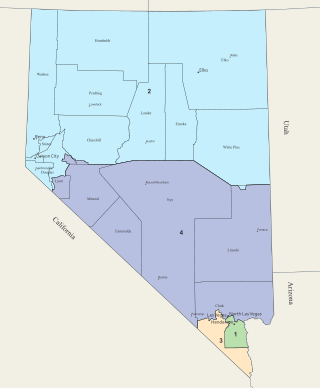
Nevada is divided into four congressional districts, each represented by a member of the United States House of Representatives. After the 2010 census, Nevada gained a fourth House seat.

<span class="mw-page-title-main">Colorado's congressional districts</span> U.S. electoral districts

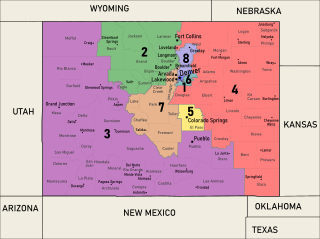
Colorado is divided into eight congressional districts, each represented by a member of the United States House of Representatives.

<span class="mw-page-title-main">Utah's congressional districts</span>

Utah is divided into 4 congressional districts, each represented by a member of the United States House of Representatives. After the 2010 census, Utah gained one House seat, and a new map was approved by the state legislature and signed into law by Governor Gary Herbert.

<span class="mw-page-title-main">Iowa's congressional districts</span> U.S. House Districts in the state of Iowa

Iowa is divided into four congressional districts, each represented by a member of the United States House of Representatives. The state's congressional map is roughly divided by quadrants in the northeast, northwest, southeast, and southwest sections of Iowa.

<span class="mw-page-title-main">Louisiana's congressional districts</span>

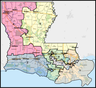
The U.S. state of Louisiana currently has six congressional districts. The state has had as many as eight districts; the eighth district was eliminated on January 9, 1993 after results of the 1990 census, and the seventh district was eliminated in 2013, following results of the 2010 census, largely because of people moving interstate after Hurricane Katrina hit the state.

<span class="mw-page-title-main">Redistricting in Arizona</span>

The U.S. state of Arizona, in common with the other U.S. states, must redraw its congressional and legislative districts every ten years to reflect changes in the state and national populations. Redistricting normally follows the completion of the United States census, which is carried out by the federal government the first year of every decade; the most recent census took place in 2020. Historically, Arizona's legislature had control over the redistricting process. However, Proposition 106, passed in 2000, delegated the power to draw congressional and legislative boundaries to a bipartisan independent commission. The Arizona Independent Redistricting Commission (AIRC) comprises two Democrats, two Republicans, and one independent chair. County and local redistricting, which normally takes place along the same timeline as congressional and legislative redistricting, is carried out by the individual county and local governments rather than the AIRC.

<span class="mw-page-title-main">Washington State Redistricting Commission</span> Commission charged with redistricting in Washington

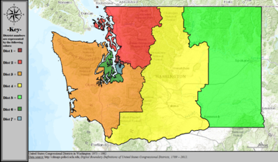
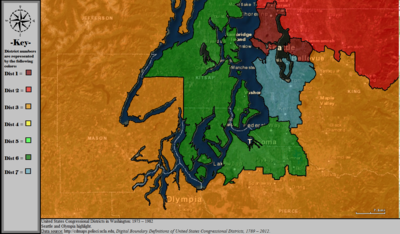
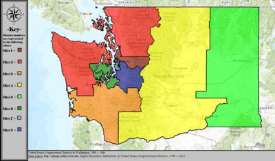
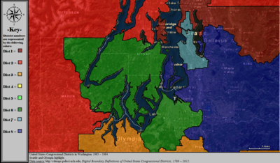
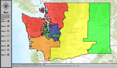
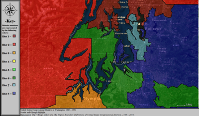
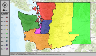
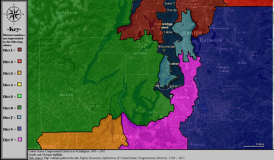
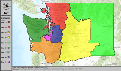
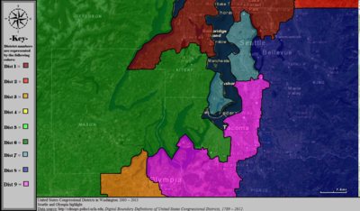
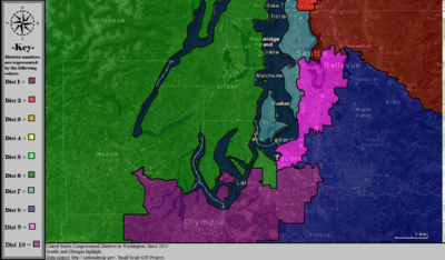
The Washington State Redistricting Commission is a decennial body charged with redrawing congressional and legislative districts in the state of Washington after each census. On November 8, 1983, Washington state passed the 74th amendment to its constitution via Senate Joint Resolution 103 to permanently establish the Redistricting Commission. Earlier that year the first commission redrew the state's congressional map after the previous one drawn by the legislature was ruled unconstitutional. Since after the 1990 census, a committee of four appointees of the majority and minority leaders of the House and Senate appoint a fifth member as non-voting chair, and meet to redistributes representative seats according to census results.

<span class="mw-page-title-main">Maryland's congressional districts</span> U.S. House districts in the state of Maryland

Maryland is divided into eight congressional districts, each represented by a member of the United States House of Representatives. After the 2020 census, the number of Maryland's seats remained unchanged, giving evidence of stable population growth relative to the United States at large.

<span class="mw-page-title-main">2020 United States redistricting cycle</span>

The 2020 United States redistricting cycle is in progress following the completion of the 2020 United States census. In all fifty states, various bodies are re-drawing state legislative districts. States that are apportioned more than one seat in the United States House of Representatives are also drawing new districts for that legislative body.

<span class="mw-page-title-main">1982 United States House of Representatives elections in Texas</span>

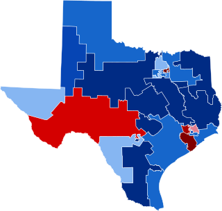
The 1982 United States House of Representatives elections in Texas occurred on November 2, 1982, to elect the members of the state of Texas's delegation to the United States House of Representatives. Texas had twenty-seven seats in the House, up three from the 1970s, apportioned according to the 1980 United States census.

References

  1. "Office of the Clerk, U.S. House of Representatives". clerk.house.gov. Retrieved January 10, 2022.
  2. "2022 Cook PVI: District Map and List". The Cook Political Report. July 12, 2022. Retrieved January 7, 2023.
  3. "Digital Boundary Definitions of United States Congressional Districts, 1789–2012" . Retrieved October 18, 2014.
  4. Non-contiguous eastern portion of district 6 (green) is actually part of district 8 (blue). Seattle Daily Times "Key Congressional Races are Heating Up" November 4, 1984. p. 12.
  5. Redistrincting. "Washington State Redistricting Commission". www.redistricting.wa.gov. Retrieved April 4, 2018.
  6. 1 2 "Clipped From The Spokesman-Review". The Spokesman-Review. April 3, 1983. p. 16. Retrieved April 22, 2020.
  7. "Clipped From Longview Daily News". Longview Daily News. March 14, 1983. p. 14. Retrieved April 22, 2020.
  8. Redistrincting. "Washington State Redistricting Commission". www.redistricting.wa.gov. Retrieved April 4, 2018.