Washington-Wheatley is a historic neighborhood in Kansas City, Missouri, United States. The neighborhood is located between 18th Street and 27th Street and Prospect Avenue to I-70.
It is mostly an African-American neighborhood on the East Side.
Washington-Wheatley is a historic neighborhood in Kansas City, Missouri, United States. The neighborhood is located between 18th Street and 27th Street and Prospect Avenue to I-70.
It is mostly an African-American neighborhood on the East Side.

The Crossroads is a neighborhood within Greater Downtown with a population of 7,491. It is centered at approximately 19th Street and Baltimore Avenue, directly south of the Downtown Loop and north of Crown Center. It is the city's main art gallery district and center for the visual arts. Dozens of galleries are located in its renovated warehouses and industrial buildings. It is also home to numerous restaurants, housewares shops, architects, designers, an advertising agency, and other visual artists. The district also has several live music venue.

Johnston Square is a neighborhood in central Baltimore, Maryland located east of the Fallsway and west of the Oliver neighborhood, bordered by Greenmount Cemetery at the north and Eager Street at the south.

Sun Valley is a neighborhood in central Denver, Colorado, bordered by I-25 on the east, Federal Blvd. on the west, 6th Avenue on the south and 20th Ave. on the north. It is located in the area known as West Denver.
Volker is a historic neighborhood in Kansas City, MO that lies just northwest of the Westport historic and entertainment district. The 39th Street West District and the Old Westport Shopping Center lie within the Volker neighborhood. The boundaries of the Volker Neighborhood are 31st Street on the north and Westport Road/43rd Street on the south. The western boundary is State Line Road. On the east, the boundaries are Roanoke Road on the north side of 39th and Southwest Trafficway south of 39th.
Brookside is a collection of neighborhoods located in Kansas City, Missouri, bounded by 55th Street on the North, Gregory on the South, Ward Parkway on the West, and Troost on the East. The neighborhood contains the Brookside Shopping District.

The Stuart Hall Building is located at 2121 Central Street in the Crossroads Arts District neighborhood of Kansas City, Missouri. The former commercial building is known as the Freight House Lofts or Stuart Hall Lofts.

West Riverside is a neighborhood of the city of New Orleans. A subdistrict of the Uptown/Carrollton Area, its boundaries as defined by the New Orleans City Planning Commission are: Magazine Street to the north, Napoleon Avenue to the east, the Mississippi River to the south and Exposition, Tchoupitoulas and Webster Streets to the west. This has not traditionally been a separate neighborhood as most of this area has been considered part of Uptown New Orleans throughout most of its history. This name was only artificially created by the New Orleans City Planning Commission and most residents do not identify with it.

CUF is a neighborhood in Cincinnati, Ohio. Its name is derived from the communities of Clifton Heights, University Heights, and Fairview. These communities surround the University of Cincinnati to the south and west of its main campus, making CUF a predominantly residential, student neighborhood. The population was 20,385 at the 2020 census.

Corryville is a neighborhood in Cincinnati, Ohio, east of the University of Cincinnati, southeast of Clifton, south and west of Avondale, northwest of Walnut Hills, and north of Mount Auburn. The population was 4,373 at the 2020 census.
Gillham Road is a major north/south main street that runs in Kansas City, Missouri from the intersection of 22nd Street at Oak Street to Harrison Road between 45th and 46th Streets. Gillham Road becomes Gillham Plaza from 31st Street to 34th Street. This causes Gillham Road to go over one block east into a residential neighborhood.

Union Hill is a historic neighborhood in Kansas City, Missouri. The neighborhood is located between 27th Street and 31st Street and Main Street to Gillham Road.
Hospital Hill is a neighborhood in Kansas City, Missouri. The neighborhood is located between 22nd Street to 25th Street and Gillham Road to Troost Avenue. This name reflects the geography and a history of public hospitals on the same site since 1870. Hospital Hill grew in concordance with the construction of local hospitals, and was further populated as the University of Missouri–Kansas City School of Medicine was established.

The Mack B. Nelson house is a historic residence located at 5500 Ward Parkway in the Sunset Hill neighborhood of the Country Club District in Kansas City, Missouri.


Armour Hills is a neighborhood located in Kansas City, Missouri. It is bounded on the west by Brookside Road, on the north by 65th Street, on the east by Oak Street and the south by Gregory Boulevard. The name of this area derives from the fact that the land was owned by members of the Armour family of the Armour and Company.
West Plaza is a neighborhood in Kansas City, Missouri located just west of the Country Club Plaza district. It is an eclectic urban neighborhood of single-family housing, small apartment buildings, and storefront businesses.
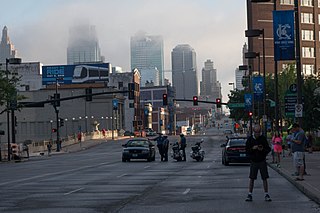
The Financial District of Kansas City, Missouri is a neighborhood in the center of Downtown Kansas City. It is bordered roughly by Ninth Street to the north, Oak Street to the east, Baltimore Avenue to the west, and Interstate 670 (Kansas-Missouri) to the south. The neighborhood includes many of the city's largest offices, and headquarters of much of Kansas City's major financial institutions.

Loyola-Notre Dame is a neighborhood located in Baltimore, Maryland. The neighborhood is named after the two universities that occupy most of the area: Notre Dame of Maryland University and Loyola University Maryland. The neighborhood is also home to the Evergreen House owned by Johns Hopkins University. The neighborhood covers all the area owned by the two universities and Evergreen House. The neighborhood does not cover a uniform area, but does have a relative definition. The northern boundary is Homeland Avenue. The eastern boundary varies among Millbrook Road, Underwood Road and other small streets. The Radnor Village, Thomas Aquinas Hall, and Loyola Public system are also included in the neighborhood despite being separated from the rest of the Loyola campus by the Radnor-Winston and Villages of Homeland neighborhoods. The southern border is Cold Spring Lane and the western border is primarily North Charles Street. Loyola extends via a pedestrian bridge over North Charles Street along Cold Spring Lane to Stony Run stream. The Loyola Fitness and Aquatics center is also across North Charles Street. The neighborhood is unique in having a very small permanent population, but housing over 4,000 students.
Valentine is a historic neighborhood in Midtown Kansas City, Missouri. It is just north of the Westport entertainment district, bounded by Broadway on the east, Southwest Trafficway on the west, 31st Street on the north, and 40th Street on the south.

The principal war memorial in Enfield Town is the cenotaph that stands in Chase Green Gardens and is a grade II listed monument with Historic England. It commemorates men lost in both the World Wars as does a plaque in the town's main post office. In addition, in 2003 a memorial to those lost in the Arctic campaign of the Second World War was unveiled.