History
In the early Iron Age the Werdenfelser Land was settled by Illyrians. Even at this early stage there were close contacts with Upper Italy over the route of the present-day Brenner-Scharnitz road. From about 500 B.C. Celts invaded this region and mixed with the indigenous population. The Romans in turn conquered the Celts around 15 B.C. and annexed the region to the Province of Raetia. Occasionally the Romans adopted settlement and river names of Veneto-Illyrian or Celtic origin, some of which have survived to the present day (Partenkirchen – Partanum, Isar – Isara). The trade route that was already established by 195 A. D. was upgraded. The Via Claudia Augusta now ran from Augsburg via Partenkirchen and Mittenwald to the Brenner Pass and continued to Bozen (Pons Drusi), where it formed a junction with the older Reschen Pass branch. The Roman road station of Partanum was the predecessor of modern-day Partenkirchen. After the collapse of the Roman Empire and the end of the Migration Period, Bajuwaren settled from about the 6th century A.D. in the valleys.
Werdenfels Castle, erected by Duke Otto of Wittelsbach in 1180 northwest of Partenkirchen, was transferred in 1294 to the Prince-Bishopric of Freising. Control of the northern approaches of the important European trading route by the Freising archbishopric enabled the population of the County of Werdenfels to become relatively wealthy over a long period of time.
With the onset of the Modern Period there was a significant economic boom as a result of stronger trade relations with Italy (see also: Fugger, Welser). The nickname Goldenes Landl ("Little Golden Land") for the Werdenfelser Land comes from this period. This development was ended by the Thirty Years' War and the population became impoverished. Later wars, such as the Wars of the Spanish and Austrian Succession in the early 18th century and Napoleonic Wars of the 19th century, also severely affected the population. In 1803, as a result of Napoleonic rule, the Prince-Bishopric of Freising was toppled and the Werdenfelser Land was given to Bavaria.
1889 saw the advent of a new source of income as the new railway link with Munich brought tourists to the region.

The Isar is a river in Tyrol, Austria and Bavaria, Germany, which is not navigable for watercraft above raft size. Its source is in the Karwendel range of the Alps in Tyrol; it enters Germany near Mittenwald and flows through Bad Tölz, Munich, and Landshut before reaching the Danube near Deggendorf. At 295 km (183 mi) in length, it is the fourth largest river in Bavaria, after the Danube, Inn, and Main. It is Germany's second most important tributary of the Danube after the Inn.
Garmisch-Partenkirchen is a Landkreis (district) in Bavaria, Germany. It is bounded by the districts of Ostallgäu, Weilheim-Schongau and Bad Tölz-Wolfratshausen, and by the Austrian state of Tyrol.

Garmisch-Partenkirchen, nicknamed Ga-Pa, is an Alpine ski town in Bavaria, southern Germany. It is the seat of government of the district of Garmisch-Partenkirchen, in the Oberbayern region, which borders Austria. Nearby is Germany's highest mountain, Zugspitze, at 2,962 metres (9,718 ft) above sea level.

Southern Bavarian or South Bavarian, is a cluster of Upper German dialects of the Bavarian group. They are primarily spoken in Tyrol, in Carinthia and in the western parts of Upper Styria. Due to the geographic isolation of these Alpine regions, many features of the Old Bavarian language from the Middle High German period have been preserved. On the other hand, the Southern Bavarian dialect area is influenced by the Rhaeto-Romance languages, locally also Slovene and to a lesser extent Italian.

Mittenwald is a German municipality in the district of Garmisch-Partenkirchen, in Bavaria.

Grainau is a municipality in the district of Garmisch-Partenkirchen, in southern Bavaria, Germany. It is located at the foot of the Zugspitze mountain, the tallest mountain in Germany in the sub-mountain range of the Wetterstein Alps which is a branch off the main mountain range it is connected to, the Alps. Lake Eibsee in Grainau lies at the foot of the Zugspitze surrounded by forest.
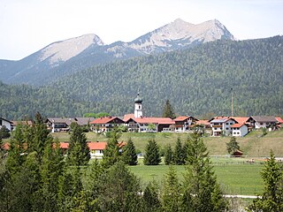
Krün is a municipality in the Upper Bavarian district of Garmisch-Partenkirchen. It belongs with Garmisch-Partenkirchen as district capital and cultural center as well as other municipalities to the region Werdenfelser Land. A few kilometers south runs the German-Austrian border.
Leutasch is a municipality in the northern part of the district Innsbruck-Land in the Austrian state of Tyrol about 30 km northwest of Innsbruck and 10 km northwest of Seefeld in Tirol
Reichsbahndirektion München was a Deutsche Reichsbahn railway division within the Bavarian Group Administration in southern Germany with its headquarters in Munich, Bavaria.

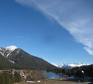
The Wetterstein mountains, colloquially called Wetterstein, is a mountain group in the Northern Limestone Alps within the Eastern Alps. It is a comparatively compact range located between Garmisch-Partenkirchen, Mittenwald, Seefeld in Tirol and Ehrwald along the border between Germany (Bavaria) and Austria (Tyrol). Zugspitze, the highest peak is at the same time the highest mountain in Germany.

The Bundesstraße 23 is a German federal highway in Bavaria that runs about 59.2 kilometres, from Peiting to the Austrian border near Garmisch-Partenkirchen. This highway (partially), along with the Bundesstraße 17 and Bundesstraße 472 highways, constitute the “German Alpine Road”. Coupled with the Bundesstraße 2 highway, it passes through cities such as Mittenwald, Innsbruck and the Brenner Pass.

The Alpspitze is a mountain, 2628 m, in Bavaria, Germany. Its pyramidal peak is the symbol of Garmisch-Partenkirchen and is one of the best known and most attractive mountains of the Northern Limestone Alps. It is made predominantly of Wetterstein limestone from the Upper Triassic.

The Munich–Garmisch-Partenkirchen railway is a single track, electrified main line railway in the southern part of the German state of Bavaria. It runs from Munich via Starnberg and Murnau to Garmisch-Partenkirchen. The first part of it was opened in 1854 and is one of the oldest lines in Germany.
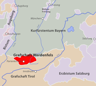
The County of Werdenfels in the present-day Werdenfelser Land in South Germany was a county that enjoyed imperial immediacy that belonged to the Bishopric of Freising from the late 13th century until the secularisation of the Bishopric in 1803.

The Mittenwald Railway, popularly known as the Karwendelbahn, is a railway line in the Alps in Austria and Germany. It connects Innsbruck via Seefeld and Mittenwald to Garmisch-Partenkirchen.

The Prince-Bishopric of Freising was an ecclesiastical principality of the Holy Roman Empire from 1294 until its secularisation in the early years of the 19th century.

The Scharnitz Pass is a narrow section of the upper Isar valley in the Northern Limestone Alps. It lies at a height of about 955 m on the Austro-German border between the states of Bavaria and Tyrol. Its name derives from the village of Scharnitz immediately to the south.
The Seefeld Saddle is a saddle and mountain pass, 1,185 m (AA), in the Northern Limestone Alps in the Austrian federal state of Tyrol. Two major transport routes run over it: the Seefelder Straße (B 177) and the Mittenwald Railway. On the Seefeld Plateau north of the saddle lies the village and ski resort of Seefeld in Tirol.

The ruins of Werdenfels Castle stand about 80 metres above the Loisach valley between Garmisch and Farchant in the county of Garmisch-Partenkirchen in Upper Bavaria. The spur castle was used until 1632 as the administrative centre of the County of Werdenfels, but began to fall into disrepair thereafter.

Lüftlmalerei, is a form of mural art that is native to villages and towns of southern Germany and Austria, especially in Upper Bavaria and in the Tyrol.

