Western Slovenia

Last updated
Western Slovenia
Zahodna Slovenija
Region
EastWestSlovenia.png
Country Flag of Slovenia.svg  Slovenia
Area [1]
  Total 8,061 km2 (3,112 sq mi)
Population [2]
  Total 933,800
  Density 120/km2 (300/sq mi)
NUTS code SI02
GDP per capita (PPS) € 24,900 (2006) [3]

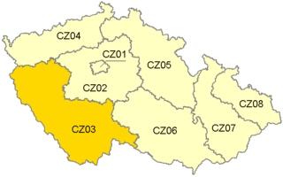
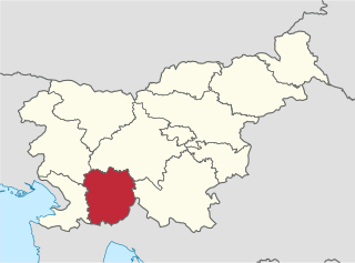
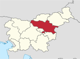
Western Slovenia (Zahodna Slovenija) is one of the two NUTS-2 Regions of Slovenia. The region forms the western part of the country and includes the cities of Ljubljana, Koper, Kranj and Nova Gorica. It is the richer of the two regions of Slovenia and its GDP per capita is 105.4% of the European Union average (€24,900 per year).

The Nomenclature of Territorial Units for Statistics is a geocode standard for referencing the subdivisions of countries for statistical purposes. The standard is developed and regulated by the European Union, and thus only covers the member states of the EU in detail. The Nomenclature of Territorial Units for Statistics is instrumental in the European Union's Structural Fund delivery mechanisms and for locating the area where goods and services subject to European public procurement legislation are to be delivered.

Slovenia republic in Central Europe

Slovenia, officially the Republic of Slovenia, is a sovereign state located in southern Central Europe at a crossroads of important European cultural and trade routes. It is bordered by Italy to the west, Austria to the north, Hungary to the northeast, Croatia to the southeast, and the Adriatic Sea to the southwest. It covers 20,273 square kilometers (7,827 sq mi) and has a population of 2.07 million. One of the successor states of the former Yugoslavia, Slovenia is a parliamentary republic and a member of the United Nations, of the European Union, and of NATO. The capital and largest city is Ljubljana.

Ljubljana Capital city in City Municipality of Ljubljana, Slovenia

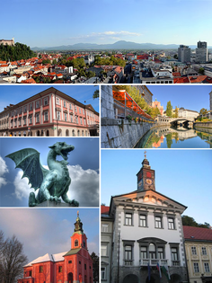
Ljubljana is the capital and largest city of Slovenia. It has been the cultural, educational, economic, political, and administrative centre of independent Slovenia since 1991.

Western Slovenia (SI02) is divided into the following statistical regions:

Central Slovenia Statistical Region Statistical region

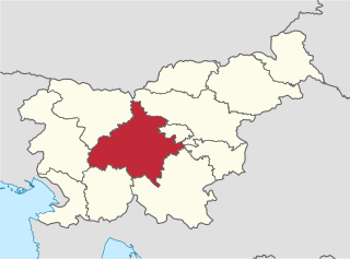
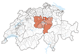
The Central Slovenia Statistical Region is a statistical region in central Slovenia.

Upper Carniola Statistical Region Statistical region

The Upper Carniola Statistical Region is a statistical region in northwest Slovenia. It is a region with high mountains, including Mount Triglav, and is almost entirely Alpine. A large part of this statistical region is protected as a national park. The relief and climate are good bases for tourism. In 2013, the region recorded almost 19% of tourist nights in Slovenia, of which 78% were by foreign tourists. The region ranked second in Slovenia in number of tourist beds per 1,000 population, even though it had just over half as many beds as the Coastal–Karst Statistical Region. In 2013, the registered unemployment rate here was the lowest in Slovenia, 3 percentage points lower than the national average and more than 8 percentage points lower than in the Mura Statistical Region, where the registered unemployment rate was the highest. Although agriculture in this region is not among the most important activities, the farms are among the largest in the country both in terms of average utilised agricultural area per farm and in terms of the number of livestock per farm.

Gorizia Statistical Region Statistical region

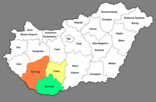
The Gorizia Statistical Region is a statistical region in western Slovenia, along the border with Italy. It is named after the Italian town of Gorizia. The Julian Alps, the Soča River, and the Vipava Valley are the most prominent natural features of this region. It contributed just over 5% to total national GDP in 2012, but in terms of GDP per capita it ranked fourth in the country. In the same year, disposable income per capita in the region the highest, in second place behind the Central Slovenia Statistical Region. Housing stock estimates indicate that at the end of 2013 the region had the highest share of dwellings with three or more rooms. The share of single-room dwellings was less than 10%. Dwellings here are larger than the Slovenian average, with 37 m² of usable floor space per person on average. The number of cars per 1,000 population is also the highest in Slovenia, with an average of 100 cars more per 1,000 people than in the Central Sava Statistical Region. However, the cars here and in the Lower Sava Statistical Region are also the oldest.

Related Research Articles

Central Switzerland Region in Switzerland

Central Switzerland is the region of the Alpine foothills geographically the heart and historically the origin of Switzerland, with the cantons of Uri, Schwyz, Obwalden, Nidwalden, Lucerne and Zug.

Southern Transdanubia Region in Hungary

Southern Transdanubia is a statistical region of Hungary. It is part of the Transdanubia region. Southern Transdanubia includes the counties of Somogy, Tolna, and Baranya. Its capital is the city of Pécs.

Coastal–Karst Statistical Region Statistical region

The Coastal–Karst Statistical Region is a statistical region in southwest Slovenia. It covers the traditional and historical regions of Slovenian Istria and most of the Karst Plateau, which traditionally belonged to the County of Gorizia and Gradisca. The region has a sub-Mediterranean climate and is Slovenia's only statistical region bordering the sea. Its natural features enable the development of tourism, transport, and special agricultural crops. More than two-thirds of gross value added are generated by services ; most was generated by activities at the Port of Koper and through seaside and spa tourism. The region recorded almost a quarter of all tourist nights in the country in 2013; slightly less than half by domestic tourists. Among foreign tourists, Italians, Austrians, and Germans predominated. In 2012 the region was one of four regions with a positive annual population growth rate (8.1‰). However, the age structure of the population was less favourable: in mid-2013 the ageing index was 133.3, which means that for every 100 inhabitants under 15 there were 133 inhabitants 65 or older. The farms in this region are among the smallest in Slovenia in terms of average utilised agricultural area per farm and in terms of the number of livestock on farms.

Jihozápad NUTS2 Region in Czech Republic

Jihozápad (Southwest) is statistical area of the Nomenclature of Territorial Units for Statistics, level NUTS 2. It includes the Plzeň Region and the South Bohemian Region.

Yugozapaden Planning Region planning region in Bulgaria

Yugozapaden Planning Region is a planning region in Bulgaria. The capital, also the national capital, is Sofia. It includes: Blagoevgrad Province, Sofia city, Sofia Province, Pernik Province and Kyustendil Province.

Eastern Slovenia Region in Slovenia

Eastern Slovenia is one of the two NUTS-2 Regions of Slovenia. The region forms the eastern part of the country and includes the cities of Maribor, Celje and Velenje. It is the poorer of the two regions of Slovenia and its GDP per capita is 72.5% of the European Union average.

Mura Statistical Region Statistical region

The Mura Statistical Region is a statistical region in northeast Slovenia. It is predominantly agricultural with field crops representing over three-quarters of the total agricultural area. Climate and soil combined have made it the region with the highest crop production, but its geographical position and inferior infrastructure put it at a disadvantage and it is the region of Slovenia with the lowest GDP per capita and the highest rate of registered unemployment.

Littoral–Inner Carniola Statistical Region Statistical region

The Littoral–Inner Carniola Statistical Region is a statistical region in southwest Slovenia. Until January 1, 2015 it was named the Inner Carniola–Karst Statistical Region.

Savinja Statistical Region Statistical region

The Savinja Statistical Region is a statistical region in Slovenia. The largest town in the region is Celje. It is named after the Savinja River. The region is very diverse in natural geography; it mainly comprises the wooded mountainous terrain attractive to tourists, the fertile Lower Savinja Valley with good conditions for growing hops, the Kozje Hills, and the Velenje Basin with lignite deposits, used for electricity production. In 2013 the region invested more than EUR 127 million in environmental protection. In 2013, the region accounted for 14% of enterprises created and 8% of enterprises shut down. The region has good natural conditions for agriculture. In 2013 this region had more than 11,000 farms, which is 15% of all farms in Slovenia, ranking the region right behind the Drava Statistical Region. In agricultural area utilised and livestock, the region was also in second place. The region is a well-known and popular tourist destination. In 2012, tourist arrivals and overnight stays in the region represented 11.1% of all tourist arrivals in Slovenia and 15.0% of all overnight stays. On average, tourists spent four nights there.

Central Sava Statistical Region Statistical region

The Central Sava Statistical Region is a statistical region in Slovenia. This statistical region in the Sava Hills is the smallest region in the country in terms of both area and population. In mid-2013 almost 43,300 people lived on 264 km², meaning that together with the Central Slovenia Statistical Region it is the most densely populated statistical region. The natural and geographic features of this region create conditions for industrial activities and more than a third of gross value added is still generated by manufacturing, mining, and other industry. In 2013, the region once again recorded the highest negative annual population growth rate (−11.9‰), which was mainly a result of migration to other statistical regions. Among all statistical regions in 2013, this region had the highest negative net migration between regions; namely, −9.5. This region also stands out by age of mothers at childbirth. In 2013 first-time mothers in the region were on average 28.5 years old, whereas first-time mothers in the Central Slovenia Statistical Region were on average 1 year older. In the same year, the number of unemployed persons increased further. The registered unemployment rate was among the highest in the country (16.6%). In comparison with other regions, this is 7 percentage points more than in the region with the lowest registered unemployment rate, Upper Carniola, and almost 1 percentage point less than in the region with the highest unemployment rate, the Mura Statistical Region. According to the labour migration index, this is the most residential statistical region. In 2013, 60% of people in the region worked in their region of residence, and 40% worked in another region.

Lake Geneva region Region in Switzerland

The Lake Geneva region or Lemanic Region is the common name of the region of Switzerland encompassing the cantons of Geneva, Vaud and Valais. It is one of the NUTS-2 regions of Switzerland.

Espace Mittelland Region in Switzerland

Espace Mittelland is a region of Switzerland, encompassing the cantons of Bern, Fribourg, Jura, Neuchâtel and Solothurn. It is one of the NUTS-2 regions of Switzerland.

Western Slovakia Region in Slovakia

Western Slovakia is one of the four NUTS-2 Regions of Slovakia. It was created at the same time as were the Bratislava, Nitra, Trnava and Trenčín regions. Western Slovakia is the most populated of the four regions of Slovakia and its GDP per capita is 68,4% of the European Union average.

Central Slovakia is one of the four NUTS-2 Regions of Slovakia. It was created at the same time as were the Žilina and the Banská Bystrica regions. Central Slovakia is the largest of the four regions of Slovakia and its GDP per capita is 58,8% of the European Union average.

Eastern Slovakia is one of the four NUTS-2 Regions of Slovakia. It was created at the same time as were the Košice and Prešov regions. Eastern Slovakia is the poorest of the four regions of Slovakia and its GDP per capita is 49,8% of the European Union average.

Continental Croatia is one of the two NUTS-2 Regions of Croatia. The region forms the continental part of the country. The most populated cities in the region are Zagreb, Osijek, Slavonski Brod, Karlovac, Sisak and Varaždin. It accounts for 56% of the country's territory and 67% of the population.

Adriatic Croatia Region in Croatia

Adriatic Croatia is one of the two NUTS-2 Regions of Croatia. The region forms the coastal part of the country. The five most populated cities in the region are Split, Rijeka, Zadar, Pula and Šibenik. It accounts for 44% of the country's territory and 33% of the population.

References

Coordinates: 46°06′00″N14°09′00″E / 46.10000°N 14.15000°E / 46.10000; 14.15000

Geographic coordinate system Coordinate system

A geographic coordinate system is a coordinate system that enables every location on Earth to be specified by a set of numbers, letters or symbols. The coordinates are often chosen such that one of the numbers represents a vertical position and two or three of the numbers represent a horizontal position; alternatively, a geographic position may be expressed in a combined three-dimensional Cartesian vector. A common choice of coordinates is latitude, longitude and elevation. To specify a location on a plane requires a map projection.