
The Orange River is the longest river in South Africa and the Orange River Basin extends extensively into Namibia and Botswana to the north. It rises in the Drakensberg mountains in Lesotho, flowing westwards through South Africa to the Atlantic Ocean. The river forms part of the international borders between South Africa and Namibia and between South Africa and Lesotho, as well as several provincial borders within South Africa. Except for Upington, it does not pass through any major cities. The Orange River plays an important role in the South African economy by providing water for irrigation and hydroelectric power. The river was named the Orange River in honour of the Dutch ruling family, the House of Orange, by the Dutch explorer Robert Jacob Gordon. Other names include Gariep River, Groote River or Senqu River.

The Vaal River is the largest tributary of the Orange River in South Africa. The river has its source near Breyten in Mpumalanga province, east of Johannesburg and about 30 kilometres (19 mi) north of Ermelo and only about 240 kilometres (150 mi) from the Indian Ocean. It then flows westwards to its conjunction with the Orange River southwest of Kimberley in the Northern Cape. It is 1,120 kilometres (700 mi) long, and forms the border between Mpumalanga, Gauteng and North West Province on its north bank, and the Free State on its south.

The Vaal Dam in South Africa was constructed in 1938 and lies 77 km south of OR Tambo International Airport. The lake behind the dam wall has a surface area of about 320 square kilometres (120 sq mi) and is 47 meters deep. The Vaal Dam lies on the Vaal River, which is one of South Africa's strongest-flowing rivers. Other rivers flowing into the dam are the Wilge River, Klip River, Molspruit and Grootspruit. It has over 800 kilometres (500 mi) of shoreline and is South Africa's second biggest dam by area and the fourth largest by volume.
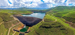
The Katse Dam, a concrete arch dam on the Malibamat'so River in Lesotho, is Africa's second largest double-curvature arch dam.. The dam is part of the Lesotho Highlands Water Project, which will eventually include five large dams in remote rural areas. The dam is just below the confluence of the Bokong River, which forms the western arm of the Katse reservoir.

Gariep Dam located in South Africa, near the town of Norvalspont, bordering the Free State and Eastern Cape provinces. Its primary purpose is for irrigation, domestic and industrial use as well as for power generation.

The Vanderkloof Dam is situated approximately 130 km (81 mi) downstream from Gariep Dam and is fed by the Orange River, South Africa's largest river. Vanderkloof Dam is the second-largest dam in South Africa, having the highest dam wall in the country at 108 metres (354 ft). The dam was commissioned in 1977; it has a capacity of 3,187.557 million cubic metres (2,584,195 acre⋅ft) and a surface area of 133.43 square kilometres (51.52 sq mi) when full. Other rivers flowing into this dam are the Berg River, two unnamed streams coming in from the direction of Reebokrand, the Knapsak River, Paaiskloofspruit, Seekoei River, Kattegatspruit and the Hondeblaf River, in a clockwise direction.

The Berg River Dam is a 68-metre (223 ft) high dam on the Berg River in South Africa. It is the centerpiece of the Berg Water Project (BWP) which is designed to capture the winter rainfall and store it for supply to Cape Town during the dry summer months. The project in turn forms an important part of the Western Cape Water Supply System (WCWSS), an intricate system of dams and bulk water infrastructure that provides water to more than 3 million people. At the inauguration of the dam in 2009, then President of South Africa Kgalema Motlanthe called the project "a good example of how public infrastructure projects can be used to contribute meaningfully to poverty eradication and to foster social empowerment of the people." The Berg River Dam was the first dam in South Africa to be designed and constructed, and is due to be operated, in accordance with the guidelines of the World Commission on Dams. It has been completed on time and within budget. The Berg River basin and the adjacent metropolitan area of Cape Town are of particular importance to the Western Cape region because, although the basin generates only about 3% of the country's water resources, it is home to about 8% of South Africa's population, and produces about 12% of GDP.
Beervlei Dam is a dam in the Groot River, Eastern Cape, South Africa. It was established in 1957, has a capacity of 85,800,000 cubic metres (3.03×10⁹ cu ft), and a surface area of 23.145 square kilometres (8.936 sq mi), and the dam wall is 31 m high. The main purpose of the dam is to provide flood absorption. The Karoo sediments in the area contain a lot of salts and it has been found that lengthy storage of water results in high water salinity. Any flood water is used as quickly as possible by the downstream irrigators and the reservoir is kept empty for extended periods.
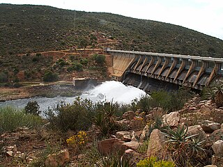
Clanwilliam Dam is a concrete gravity dam on the Olifants River, near Clanwilliam, Western Cape, South Africa. It was established in 1935, and the wall was raised to its current height of 43 metres (141 ft) in 1964. The main purpose of the dam is to provide irrigation water to the agricultural region downstream. It has a capacity of 121,800,000 cubic metres (4.30×10⁹ cu ft).

Elandskloof Dam is a gravity type dam located on the Elands River, near Villiersdorp, Western Cape, South Africa. It was established in 1976. The primary purpose of the dam is for irrigation and domestic water supply. Its hazard potential has been ranked high (3).
Goedertrouw Dam is an earth-filled dam in South Africa. The Dam was constructed on the Mhlathuze River, near Eshowe, KwaZulu-Natal, in 1980. It currently has a capacity of 301 million m3 and is principally for provision of water to the industrial complex at Richards Bay. It serves also as reservoir for irrigation and domestic use. The hazard potential of the dam has been ranked high (3).
Loskop Dam is a combined gravity & arch type dam located on the Olifants River, near Groblersdal, Mpumalanga, South Africa. It was established in 1939 and has been renovated in 1979. The dam is situated in the Loskop Dam Nature Reserve and it serves mainly for irrigation purposes. The hazard potential of the dam has been ranked high (3).
Middle Letaba Dam is an earth-fill type dam located on the Middle Letaba River, 40 km east of Elim and 40 km west of Giyani, Limpopo, South Africa. The source of the Middle Letaba river rises high in the tropical mountains of Magoebaskloof near Tzaneen, where rainfall is abundant during the summer months. The river passes numerous villages and its flow becomes quite strong when it reaches the village of Magoro.
Mokolo Dam is a rock-fill type dam located on the Mokolo River, near Lephalale, Limpopo, South Africa. It was established in 1980. The Malmanies River and the Bulspruit River, two tributaries of the Mokolo, also enter the dam from its left side. The dam supplies water to Lephalale town. The dam mainly serves for municipal and industrial purposes and its hazard potentials has been ranked high (3).
Ncora Dam is a gravity type dam located on the Tsomo River, near Tsomo, Eastern Cape, South Africa. It was established in 1972 and serves mainly for irrigation purposes. The hazard potential of the dam has been ranked high (3).
Welbedacht Dam is a concrete-gravity type dam situated in South Africa, and was established in 1973. Bloemfontein is the sixth-largest city in South Africa, with a population around 300 000. It is situated in the Modder River catchment, which has insufficient water resources to meet the growing water requirements. The water supply to Bloemfontein is, therefore, augmented from the adjacent Caledon River by means of the Caledon - Modder River Government Water Scheme (CMRGWS).
Hazelmere Dam is a combined concrete gravity type dam located on the Mdloti River, Kwazulu Natal, South Africa. It was established in 1977 and its primary purpose is to serve for irrigation and domestic use. The hazard potential of the dam assembly has been ranked high (3).
Injaka Dam, also spelled Inyaka Dam is an earth-fill type dam located on the Ngwaritsane River, near Bushbuckridge, Mpumalanga, South Africa. It was established in 2001 and its primary purpose is to store water for irrigation use. The hazard potential of the dam has been ranked as high (3).

The Crocodile River is a river in South Africa. After its confluence with the Marico River, both rivers form the Limpopo River.


