Air traffic control (ATC) is a service provided by ground-based air traffic controllers who direct aircraft on the ground and through controlled airspace, and can provide advisory services to aircraft in non-controlled airspace. The primary purpose of ATC worldwide is to prevent collisions, organize and expedite the flow of air traffic, and provide information and other support for pilots. In some countries, ATC plays a security or defensive role, or is operated by the military.
The air traffic control radar beacon system (ATCRBS) is a system used in air traffic control (ATC) to enhance surveillance radar monitoring and separation of air traffic. It consists of a rotating ground antenna and transponders in aircraft. The ground antenna sweeps a narrow vertical beam of microwaves around the airspace. When the beam strikes an aircraft, the transponder transmits a return signal back giving information such as the flight number designation and altitude of the aircraft. ATCRBS assists air traffic control (ATC) surveillance radars by acquiring information about the aircraft being monitored, and providing this information to the radar controllers. The controllers can use the information to identify radar returns from aircraft and to distinguish those returns from ground clutter.
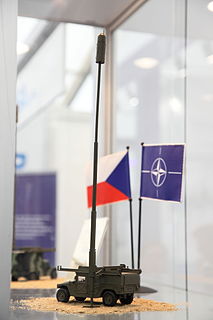
VERA -VERA passive radar is an electronic support measures (ESM) system that uses measurements of time difference of arrival (TDOA) of pulses at three or four sites to accurately detect and track airborne emitters. It is reportedly able to detect military "invisible aircraft".

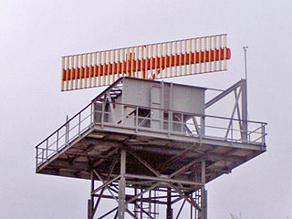
An airport surveillance radar (ASR) is a radar system used at airports to detect and display the presence and position of aircraft in the terminal area, the airspace around airports. It is the main air traffic control system for the airspace around airports. At large airports it typically controls traffic within a radius of 60 miles (96 km) of the airport below an elevation of 25,000 feet. The sophisticated systems at large airports consist of two different radar systems, the primary and secondary surveillance radar. The primary radar typically consists of a large rotating parabolic antenna dish that sweeps a vertical fan-shaped beam of microwaves around the airspace surrounding the airport. It detects the position and range of aircraft by microwaves reflected back to the antenna from the aircraft's surface. In the US the primary radar operates at a frequency of 2.7 - 2.9 GHz in the S band with a peak radiated power of 25 kW and an average power of 2.1 kW. The secondary surveillance radar consists of a second rotating antenna, often mounted on the primary antenna, which interrogates the transponders of aircraft, which transmits a radio signal back containing the aircraft's identification, barometric altitude, and an emergency status code, which is displayed on the radar screen next to the return from the primary radar. It operates at a frequency of 1.03 - 1.09 GHz in the L band with peak power of 160 - 1500 W.

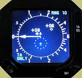
A transponder is an electronic device that produces a response when it receives a radio-frequency interrogation. Aircraft have transponders to assist in identifying them on air traffic control radar. Collision avoidance systems have been developed to use transponder transmissions as a means of detecting aircraft at risk of colliding with each other.
ERAM is an FAA Air Traffic Control system designed to "allow faster processing of route requests and in flight route changes".
The Standard Terminal Automation Replacement System (STARS) is an air traffic control automation system manufactured by Raytheon and is currently being used in many TRACONs around the United States by the FAA. STARS is intended to replace the Automated Radar Terminal System (ARTS). ARTS is still in use at many air traffic control facilities.

SASS-C is an acronym for "Surveillance Analysis Support System for ATC-Centre". SASS-C Service is part of Eurocontrol Surveillance Tools unit.
The Next Generation Air Transportation System (NextGen) is an ongoing modernization project of the United States' National Airspace System (NAS). The US Federal Aviation Administration (FAA) began work on NextGen improvements in 2007 and plans to have all major components in place by 2025.
Common ARTS is an air traffic control computer system that air traffic controllers use to track aircraft.
The aviation transponder interrogation modes are the standard formats of pulsed sequences from an interrogating Secondary Surveillance Radar (SSR) or similar Automatic Dependent Surveillance-Broadcast (ADS-B) system. The reply format is usually referred to as a "code" from a transponder, which is used to determine detailed information from a suitably equipped aircraft.

Automatic dependent surveillance—broadcast (ADS–B) is a surveillance technology in which an aircraft determines its position via satellite navigation and periodically broadcasts it, enabling it to be tracked. The information can be received by air traffic control ground stations as a replacement for secondary surveillance radar, as no interrogation signal is needed from the ground. It can also be received by other aircraft to provide situational awareness and allow self-separation.

Anchorage Air Route Traffic Control Center (PAZA/ZAN) is located just outside the main gate of Joint Base Elmendorf-Richardson at 700 North Boniface Parkway in Anchorage, Alaska, United States. The Anchorage ARTCC is one of 22 Air Route Traffic Control Centers in the United States.
This is a list of the acronyms and abbreviations used in avionics.

PHOENIX is a multipurpose Radar Data Processing System(RDPS) / Surveillance Data Processing System (SDPS) - a.k.a. tracker - used for many ATC applications in the Deutsche Flugsicherung (DFS), and is continuously extended and maintained ever since. PHOENIX is also foreseen as a fundamental component for all future ATM systems in the DFS into the 2020s and part of the DFS initiative for “ATS componentware” in the European SESAR programme.
Flightradar24 is a Swedish internet-based service that shows real-time commercial aircraft flight information on a map. It includes flight tracks, origins and destinations, flight numbers, aircraft types, positions, altitudes, headings and speeds. It can also show time-lapse replays of previous tracks and historical flight data by airline, aircraft, aircraft type, area or airport. It aggregates data from multiple sources but, outside of the United States, mostly from crowdsourced information gathering by volunteers with ADS-B receivers. The service was founded as a hobby in 2006 by two Swedish aviation enthusiasts. It is available via a web page or mobile device apps. The Guardian considers the site to be "authoritative".
Airport Surface Surveillance Capability (ASSC) is a runway-safety tool that displays aircraft and ground vehicles on the airport surface, as well as aircraft on approach and departure paths within a few miles of the airport. The tool allows air traffic controllers and air crew in cockpits equipped with Automatic Dependent Surveillance-Broadcast (ADS-B) to detect potential runway conflicts by providing detailed coverage of movement on runways and taxiways. By collecting and fusing data from a variety of sources, ASSC is able to track vehicles and aircraft on airport surfaces and obtain identification information from aircraft ADS-B transponders.