Wilson's Mills, North Carolina

Last updated

Wilson's Mills, North Carolina
WilsonsMills.jpg
NCMap-doton-WilsonsMills.PNG
Location of Wilsons Mills, North Carolina
Coordinates: 35°35′09″N78°21′56″W / 35.58583°N 78.36556°W / 35.58583; -78.36556
Country United States
State North Carolina
County Johnston
Area
[1]
  Total5.51 sq mi (14.28 km2)
  Land5.51 sq mi (14.26 km2)
  Water0.01 sq mi (0.02 km2)
Elevation
[2]
226 ft (69 m)
Population
 (2020)
  Total2,534
  Density460.23/sq mi (177.69/km2)
Time zone UTC-5 (Eastern (EST))
  Summer (DST) UTC-4 (EDT)
ZIP code
27593
Area code 919
FIPS code 37-74580 [3]
GNIS feature ID2406893 [2]
Website www.wilsonsmillsnc.org

Wilson's Mills is a town in Johnston County, North Carolina, United States. In 2010, the population was 2,277, [4] up from 1,291 in 2000. As of 2018, the estimated population was 2,689. [5]

Contents

Geography

Wilson's Mills is located in north-central Johnston County. It is 6 miles (10 km) north of Smithfield, the county seat. U.S. Route 70 passes through the southern side of the town, leading northwest 26 miles (42 km) to Raleigh and southeast 6 miles (10 km) to Interstate 95 at Selma.

According to the United States Census Bureau, Wilson's Mills has a total area of 4.5 square miles (11.7 km2), of which 0.01 square miles (0.02 km2), or 0.16%, are water. [4]

Demographics

Historical population
CensusPop.Note
1930 350
2000 1,291
2010 2,27776.4%
2020 2,53411.3%
U.S. Decennial Census [6]

2020 census

Wilson's Mills racial composition [7]
RaceNumberPercentage
White (non-Hispanic)1,18046.57%
Black or African American (non-Hispanic)49319.46%
Native American 110.43%
Asian 60.24%
Other/Mixed 773.04%
Hispanic or Latino 76730.27%

As of the 2020 United States census, there were 2,534 people, 840 households, and 648 families residing in the town.

2000 census

As of the census [3] of 2000, there were 1,291 people, 465 households, and 357 families residing in the town. The population density was 352.9 inhabitants per square mile (136.3/km2). There were 505 housing units at an average density of 138.0 per square mile (53.3/km2). The racial makeup of the town was 73.04% White, 23.93% African American, 0.54% Native American, 2.32% from other races, and 0.15% from two or more races. Hispanic or Latino of any race were 4.88% of the population.

There were 465 households, of which 41.7% had children under the age of 18 living with them, 60.2% were married couples living together, 12.7% had a female householder with no husband present, and 23.2% were non-families. 19.8% of all households were made up of individuals, and 7.3% had someone living alone who was 65 years of age or older. The average household size was 2.78 and the average family size was 3.19.

In the town, the population was spread out, with 30.1% under the age of 18, 6.9% from 18 to 24, 35.8% from 25 to 44, 20.6% from 45 to 64, and 6.6% who were 65 years of age or older. The median age was 32 years. For every 100 females, there were 99.8 males. For every 100 females age 18 and over, there were 94.4 males.

The median income for a household in the town was $44,650, and the median income for a family was $49,219. Males had a median income of $33,150 versus $25,188 for females. The per capita income for the town was $17,157. About 9.4% of families and 9.8% of the population were below the poverty line, including 14.0% of those under age 18 and 9.1% of those age 65 or over.

Law and government

Wilson's Mills operates under a council-manager government. The town council consists of the mayor and five council members. All council members are elected at-large. [8]

Education

Related Research Articles

<span class="mw-page-title-main">Wilson County, North Carolina</span> County in North Carolina, United States

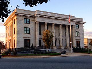
Wilson County is a county located in the U.S. state of North Carolina. As of the 2020 census, the population was 78,784. The county seat is Wilson. The county comprises the Wilson, NC Micropolitan Statistical Area, which is also included within the Rocky Mount-Wilson-Roanoke Rapids, NC Combined Statistical Area.

<span class="mw-page-title-main">Elon, North Carolina</span> Town in North Carolina, United States

Elon is a town in Alamance County, North Carolina, United States. It is part of the Burlington metropolitan statistical area. The population as of the 2020 census was 11,324. The town of Elon is home to Elon University.

<span class="mw-page-title-main">Graham, North Carolina</span> City in North Carolina, United States

Graham is a city in Alamance County, North Carolina, United States. It is part of the Burlington, North Carolina Metropolitan Statistical Area. As of the 2020 census the population was 17,153. It is the county seat of Alamance County.

<span class="mw-page-title-main">Swepsonville, North Carolina</span> Town in North Carolina, United States

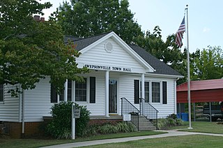
Swepsonville is a town in Alamance County, North Carolina, United States. It is part of the Burlington, North Carolina Metropolitan Statistical Area. The population at the 2010 census was 1,154.

St. James or Saint James is a town in Brunswick County, North Carolina, United States. The population was 3,165 at the 2010 census, up from 804 in 2000. It is part of the Wilmington, NC Metropolitan Statistical Area.

<span class="mw-page-title-main">Drexel, North Carolina</span> Town in North Carolina, United States

Drexel is a town in Burke County, North Carolina, United States. The population was 1,858 at the 2010 census. It is part of the Hickory–Lenoir–Morganton Metropolitan Statistical Area.

<span class="mw-page-title-main">Lawndale, North Carolina</span> Town in North Carolina, United States

Lawndale is a town in Cleveland County, North Carolina, United States, situated along the First Broad River. The population was 606 at the 2010 census.

<span class="mw-page-title-main">Hope Mills, North Carolina</span> Town in North Carolina, United States

Hope Mills is a town in Cumberland County, North Carolina, United States. Its population was 15,176 at the 2010 census.

<span class="mw-page-title-main">Conetoe, North Carolina</span> Town in North Carolina, United States

Conetoe is a 246-square-mile (640-square-kilometer) is a town in Edgecombe County, North Carolina, United States. It is part of the Rocky Mount, North Carolina Metropolitan Statistical Area. The population was 294 at the 2010 census.

<span class="mw-page-title-main">Clemmons, North Carolina</span> Village in North Carolina

Clemmons is a village in Forsyth County, North Carolina, United States and a suburb of Winston-Salem. The population was 21,177 at the 2020 census, with an estimated population of 21,517 in 2021.

<span class="mw-page-title-main">Spencer Mountain, North Carolina</span> Town in North Carolina, United States

Spencer Mountain is a town in Gaston County, North Carolina, United States. The population was 37 at the 2010 census.

<span class="mw-page-title-main">Princeton, North Carolina</span> Town in North Carolina, United States

Princeton is a town in Johnston County, North Carolina, United States. As of the 2010 census it had a population of 1,194. Each May the town celebrates Princeton Community Day, a festival dedicated to promoting community involvement and town pride. The town holds municipal elections in November in odd-number years to elect its mayor and town council.

<span class="mw-page-title-main">Troy, North Carolina</span> Town in North Carolina, United States

Troy is a town in Montgomery County, North Carolina, United States. The population was 3,188 at the 2010 census. It is the county seat of Montgomery County. A short story by Charles W. Chesnutt, The Sheriff's Children, is set in Troy.

<span class="mw-page-title-main">Cleveland, North Carolina</span> Town in North Carolina, United States

Cleveland is a town in the Cleveland Township of Rowan County, North Carolina, United States. The population was 871 at the 2010 census.

<span class="mw-page-title-main">Richfield, North Carolina</span> Town in North Carolina, United States

Richfield is a town in Stanly County, North Carolina, United States. The town was originally called "Ritchie's Field," for the prominent Ritchie family who established the post office, sawmill, and streets of the settlement.

<span class="mw-page-title-main">Danbury, North Carolina</span> City in North Carolina, United States

Danbury is a city located in Danbury Township, Stokes County, North Carolina, United States. As of the 2020 census, the city had a total population of 142. It is the county seat of Stokes County. Danbury is located on North Carolina Highway 8/89 approximately 20 miles (32 km) north of Winston-Salem and is the "Gateway to Hanging Rock". The Stokes County Government Center, Arts Council, school board, county jail, a public library, a post office, and other public services are found within the town limits. LifeBrite Community Hospital of Stokes is located about a half mile northwest of the town. North Stokes High School, a big part of town, is located 7.4 miles to the northwest.

<span class="mw-page-title-main">Yadkinville, North Carolina</span> Town in North Carolina, United States

Yadkinville is a town in Yadkin County, North Carolina, United States. The population was 2,995 at the 2020 census. Located in the Piedmont Triad, it is the county seat and most populous city of Yadkin County.

<span class="mw-page-title-main">Sharpsburg, North Carolina</span> Town in North Carolina, United States

Sharpsburg is a town in Edgecombe, Nash, and Wilson counties, North Carolina, United States. It is part of the Rocky Mount, North Carolina Metropolitan Statistical Area. The population was 2,024 at the 2010 Census.

<span class="mw-page-title-main">Weddington, North Carolina</span> Town in North Carolina, United States

Weddington is a suburban town in Union County, North Carolina, United States. The population was 9,459 at the 2010 census. It is a suburb in the Charlotte metropolitan area. The current mayor of Weddington is Jim Bell.

Edwards is a hamlet in St. Lawrence County, New York, United States. The population was 439 at the 2010 census. It was an incorporated village until dissolution in 2012.

References

  1. "ArcGIS REST Services Directory". United States Census Bureau. Retrieved September 20, 2022.
  2. 1 2 U.S. Geological Survey Geographic Names Information System: Wilson's Mills, North Carolina
  3. 1 2 "U.S. Census website". United States Census Bureau . Retrieved January 31, 2008.
  4. 1 2 "Geographic Identifiers: 2010 Census Summary File 1 (G001): Wilson's Mills town, North Carolina". American Factfinder. U.S. Census Bureau. Archived from the original on February 13, 2020. Retrieved October 15, 2018.
  5. "Population and Housing Unit Estimates" . Retrieved December 18, 2019.
  6. "Census of Population and Housing". Census.gov. Retrieved June 4, 2015.
  7. "Explore Census Data". data.census.gov. Retrieved December 23, 2021.
  8. "Meet Our Mayor and Council".
  9. Wilson's Mills Elementary School