The Santa Monica Mountains Conservancy is an agency of the state of California in the United States founded in 1980 and dedicated to the acquisition of land for preservation as open space, for wildlife and California native plants habitat Nature Preserves, and for public recreation activities.

The Santa Susana Mountains are a transverse range of mountains in Southern California, north of the city of Los Angeles, in the United States. The range runs east-west, separating the San Fernando Valley and Simi Valley on its south from Santa Clara River Valley to the north and Santa Clarita Valley to the northeast. The Oxnard Plain is to the west of Santa Susana Mountains.

Malibu Creek State Park is a state park of California, United States, preserving the Malibu Creek canyon in the Santa Monica Mountains. The 8,215-acre (3,324 ha) park was established in 1974. Opened to the public in 1976, the park is also a component of Santa Monica Mountains National Recreation Area.

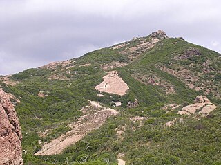
El Escorpión Park is a three-acre park located in the Simi Hills of the western San Fernando Valley, in the West Hills district of Los Angeles, California. The park contains the geographic landmark known as Escorpión Peak or Castle Peak, a 1,475-foot-tall rocky peak seen from most parts of the park and the surrounding community.

The Simi Hills are a low rocky mountain range of the Transverse Ranges in eastern Ventura County and western Los Angeles County, of southern California, United States.

Topanga State Park is a California state park located in the Santa Monica Mountains, within Los Angeles County, California. It is part of the Santa Monica Mountains National Recreation Area.

The Upper Las Virgenes Canyon Open Space Preserve is a large open space nature preserve owned and operated by the Santa Monica Mountains Conservancy spanning nearly 3,000 acres (1,200 ha) in the Simi Hills of western Los Angeles County and eastern Ventura County.

Boney Mountain in Ventura County, California is one of the highest peaks in the Santa Monica Mountains. The prominent mountain visible from Newbury Park, California is 2,825 feet (861 m).. It is also known as Boney Peak. The mountain contains four of the highest peaks in the coastal range of the Santa Monica Mountains: Boney Peak, Sandstone Peak, Exchange Peak, and Tri Peaks. The highest summit in the Santa Monica Mountains is Sandstone Peak, situated less than a mile northeast of Boney Peak along the same ridge of volcanic rock. It is the top section of a mass of volcanic rock which solidified around 15 million years ago, and was later uplifted to its dominant position, overshadowing western Conejo Valley. The Chumash Native Americans have a long and deeply spiritual history of interaction at and near the mountain, and the peak is considered a sacred mountain to the Chumash people.

Point Mugu State Park is a state park located in the Santa Monica Mountains National Recreation Area in Southern California. The rugged, nearly impassible shoreline of the western Santa Monica Mountains gives way to tidal lagoons and coastal sand dunes at Mugu Rock. The western edge of the park adjoins Mugu Lagoon which is a protected area within Naval Air Station Point Mugu.
Rustic Canyon is a residential neighborhood and canyon in eastern Pacific Palisades, on the west side of Los Angeles, California. It is along Rustic Creek, in the Santa Monica Mountains.

The Backbone Trail is a long distance trail extending 67.79 miles (109.10 km) across the length of the Santa Monica Mountains in the U.S. state of California. Its western terminus is Point Mugu State Park and its eastern terminus is Will Rogers State Historic Park in Pacific Palisades. The trail is open to hikers throughout its length; dogs, mountain bicyclists and horseback riders are allowed on portions of the trail as posted.

Ramirez Canyon Park is a public park owned by the state of California. Barbra Streisand donated this estate to the state-run Santa Monica Mountains Conservancy in 1993. The estate has 22.5 acres (9.1 ha) of lush vegetation, streams, and bridges. There are five homes on the estate.
Sandstone Peak, also known as Mount Allen, is a mountain in Ventura County, California, and the highest summit in the Santa Monica Mountains with an elevation of 3,114 feet (949 m). Located near the western edge of the Santa Monica Mountains National Recreation Area, the summit provides panoramic views of Malibu, The Pacific Ocean, Santa Monica, the Conejo Valley, and four of the Channel Islands. The Sandstone Peak Trail, which leads to the top, connects to a vast trail system in the area, including the Backbone Trail. The mountain is highly popular with climbers, hikers, campers, and photographers.
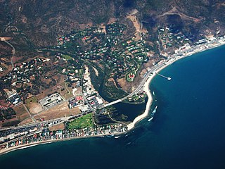
The Corral Canyon is a valley of the Santa Monica Mountains that slopes down to the striking and diverse terrain of the Malibu coast.
Satwiwa was a former Chumash village in the Santa Monica Mountains of Newbury Park, California. The current Satwiwa Native American Indian Culture Center is operated by the National Park Service in cooperation with the Friends of Satwiwa. Satwiwa has been inhabited by Chumash Indians for over 10,000 years. It is situated at the foothills of Boney Mountain, a sacred mountain for the Chumash.

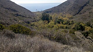
Big Sycamore Canyon, often shortened to Sycamore Canyon, is a major feature of Point Mugu State Park, in Ventura County, California, United States. Sycamore Canyon is situated in the northernmost region of the Santa Monica Mountains National Recreation Area below the 3,000 feet (910 m) peaks of the Boney Mountain State Wilderness Area. The canyon begins on the north slope of Boney Mountain and heads north down the slope. The canyon then heads southwest past Rancho Sierra Vista/Satwiwa to Sycamore Cove on the coastline.
Susan B. Nelson was an American environmental activist who is best known as the mother of the Santa Monica Mountains National Recreation Area.