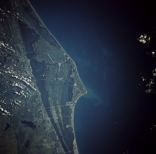
Cape Canaveral is a cape in Brevard County, Florida, in the United States, near the center of the state's Atlantic coast. Officially Cape Kennedy from 1963 to 1973, it lies east of Merritt Island, separated from it by the Banana River. It is part of a region known as the Space Coast, and is the site of the Cape Canaveral Space Force Station. Since many U.S. spacecraft have been launched from both the station and the Kennedy Space Center on adjacent Merritt Island, the two are sometimes conflated with each other.

Merritt Island is a peninsula, commonly referred to as an island, in Brevard County, Florida, United States, located on the eastern Florida coast, along the Atlantic Ocean. It is also the name of an unincorporated town in the central and southern parts of the island and a census-designated place (CDP).

Pedro Menéndez de Avilés was a Spanish admiral, explorer and conquistador from Avilés, in Asturias, Spain. He is notable for planning the first regular trans-oceanic convoys, which became known as the Spanish treasure fleet, and for founding St. Augustine, Florida, in 1565. This was the first successful European settlement in La Florida and the most significant city in the region for nearly three centuries.

The Indian River Lagoon is a grouping of three lagoons: the Mosquito Lagoon, the Banana River, and the Indian River, on the Atlantic Coast of Florida; one of the most biodiverse estuaries in the Northern Hemisphere and is home to more than 4,300 species of plants and animals.

Spanish Florida was the first major European land claim and attempted settlement in North America during the European Age of Discovery. La Florida formed part of the Captaincy General of Cuba, the Viceroyalty of New Spain, and the Spanish Empire during Spanish colonization of the Americas. While its boundaries were never clearly or formally defined, the territory was initially much larger than the present-day state of Florida, extending over much of what is now the southeastern United States, including all of present-day Florida plus portions of Georgia, South Carolina, North Carolina, Alabama, Mississippi, and the Florida Parishes of Louisiana. Spain's claim to this vast area was based on several wide-ranging expeditions mounted during the 16th century. A number of missions, settlements, and small forts existed in the 16th and to a lesser extent in the 17th century; they were eventually abandoned due to pressure from the expanding English and French colonial settlements, the collapse of the native populations, and the general difficulty in becoming agriculturally or economically self-sufficient. By the 18th century, Spain's control over La Florida did not extend much beyond a handful of forts near St. Augustine, St. Marks, and Pensacola, all within the boundaries of present-day Florida.

The Ais or Ays were a Native American people of eastern Florida. Their territory included coastal areas and islands from approximately Cape Canaveral to the Indian River. The Ais chiefdom consisted of a number of towns, each led by a chief who was subordinate to the paramount chief of Ais; the Indian River was known as the "River of Ais" to the Spanish. The Ais language has been linked to the Chitimacha language by linguist Julian Granberry, who points out that "Ais" means "the people" in the Chitimacha language. The Ais were hunter-gatherers and food was plentiful. They ate fish, turtle, shellfish, cocoplums, sabal palm berries and other gathered fruits. Prior to contact with European colonizers, the Ais population had grown to several hundred thousand and may have flourished for over 10,000 years.
Jonathan Dickinson (1663–1722) was a merchant from Port Royal, Jamaica who was shipwrecked on the southeast coast of Florida in 1696, along with his family and the other passengers and crew members of the ship. He wrote about their experiences. The party was held captive by Jobe ("Hoe-bay") Indians for several days, and then was allowed to travel by small boat and on foot the 230 miles up the coast to Saint Augustine. The party was subjected to harassment and physical abuse at almost every step of the journey to Saint Augustine. Five members of the party died from exposure and starvation on the way.

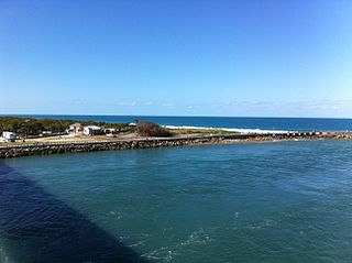
The St. Lucie Inlet, Florida is located between Hutchinson Island and Jupiter Island in Martin County, Florida, at coordinates 27°09′58″N80°09′24″W. The St. Lucie Inlet is one of six inlets into the Indian River Lagoon.

The Jaega were Native Americans living in a chiefdom of the same name, which included the coastal parts of present-day Martin County and northern Palm Beach County, Florida at the time of initial European contact, and until the 18th century. The name Jobé, or Jové, has been identified as a synonym of Jaega, a sub-group of the Jaega, or a town of the Jaega.

The Halifax River is part of the Atlantic Intracoastal Waterway, located in northeast Volusia County, Florida. The waterway was originally known as the North Mosquito River, but was renamed after George Montagu-Dunk, 2nd Earl of Halifax, during the British occupation of Florida (1763–1784).
Turtle Mound is a prehistoric archaeological site located 9 miles (14 km) south of New Smyrna Beach, Florida, on State Road A1A. On September 29, 1970, it was added to the U.S. National Register of Historic Places. It is the largest shell midden on the mainland United States, with an approximate height of 50 feet (15 m). The mound extends for over 600 feet (180 m) along the Indian River shoreline and contains over 35,000 cubic yards (27,000 m3) of shells. Turtle Mound was estimated to be 75 feet (23 m) high before it was reduced by shellrock mining in the 19th and 20th centuries. Because it is visible seven miles out at sea, early Spanish explorers and subsequent mariners used the large mound as a landmark for coastal navigation. Today, the site is owned and managed by the National Park Service as part of Canaveral National Seashore.
The Surruque people lived along the middle Atlantic coast of Florida during the 16th and 17th centuries. They may have spoken a dialect of the Timucua language, but were allied with the Ais. The Surruque became clients of the Spanish government in St. Augustine, but were not successfully brought into the Spanish mission system.

Douglas Dummett (1806–1873) was an American planter, plantation owner, and politician. He served as a member of the Legislative Council of the Territory of Florida representing St. Johns County in 1843, and a member of the Florida House of Representatives representing Mosquito County in 1845. He was instrumental in developing the Indian River Citrus industry in Florida.

Nocoroco is the site of a Timucuan village located on the Tomoka River, in Tomoka State Park. The park is located two or three miles north of Ormond Beach, Florida on North Beach Street.
The indigenous peoples of Florida lived in what is now known as Florida for more than 12,000 years before the time of first contact with Europeans. However, the indigenous Floridians living east of the Apalachicola River had largely died out by the early 18th century. Some Apalachees migrated to Louisiana, where their descendants now live; some were taken to Cuba and Mexico by the Spanish in the 18th century, and a few may have been absorbed into the Seminole and Miccosukee tribes.
South Beaches is an unofficial area in Brevard County, Florida, United States. It includes cities, towns and unincorporated area on the barrier island south of Patrick Space Force Base. The cities and towns include: South Patrick Shores, Satellite Beach, Indian Harbour Beach, Indialantic and Melbourne Beach, and the city of Melbourne.
Pedro de Ibarra was a Spanish general who served as a Royal Governor of Spanish Florida.

This is a timeline of the U.S. state of Florida.
Ponce de León Island was a proposed name for the 45 miles (72 km) long, barrier island stretching from Cape Canaveral to Sebastian Inlet in Brevard County in central Florida, located on the Atlantic Ocean. The population was 67,933 at the 2010 United States Census. The barrier island is 21.4 square miles (55 km2). Another proposed name for this area was Ais Island after the native Ais people who originally inhabited the area. Currently, the island has not yet been designated any official name.
The History of Brevard County can be traced to the prehistory of native cultures living in the area from pre-Columbian times to the present age. Brevard County is a county in the U.S. state of Florida, along the coast of the Atlantic Ocean. The geographic boundaries of the county have changed significantly since its founding. The county is named for Judge Theodore W. Brevard, an early settler, and state comptroller, and was originally named St. Lucie County until 1855. The official county seat has been located in Titusville since 1894, although most of the county's administration is performed from Viera.
