
The geography of France consists of a terrain that is mostly flat plains or gently rolling hills in the north and west and mountainous in the south and the east.
Rutja is a village in Haljala Parish, Lääne-Viru County, northern Estonia. It is located on the coast of the Bay of Finland and on the western shore of the Selja river. It neighbours Karepa in the east.
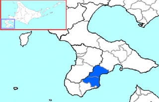
Kamiiso is a district located in Oshima Subprefecture, Hokkaido, Japan.
Castillejo-Sierra is a municipality in Cuenca, Castile-La Mancha, Spain. It has a population of 48.

This is a list of the extreme points of Azerbaijan, the points that are farther north, south, east or west than any other location.
Ituero y Lama is a municipality located in the province of Segovia, Castile and León, Spain. According to the 2004 census (INE), the municipality has a population of 9.1 million inhabitants.

Yenikənd, is a village in Agsu Rayon, Azerbaijan. The village forms part of the municipality of Gürcüvan.
Hivəri is a village in the Lerik Rayon of Azerbaijan. The village forms part of the municipality of Qosmalyan.
Bağəli is a village in the Ismailli Rayon of Azerbaijan. The village forms part of the municipality of Ərəkit.
Arabbazarly is a village in the Kurdamir Rayon of Azerbaijan.
Yenikənd is a village in the Gadabay Rayon of Azerbaijan. The village forms part of the municipality of Gərgər.
Mürtülü is a village and municipality in the Kurdamir Rayon of Azerbaijan.
Çöl Qubalı is a village and municipality in the Kurdamir Rayon of Azerbaijan.
Ayıtala is a village in the municipality of Düzyurd in the Gadabay Rayon of Azerbaijan.
Krusenstern Strait is a strait that separates the islands of Raikoke and Shiashkotan in the Kuril Islands, Russia. It is separated into two passages by the Lovushki Rocks and is 61.2 km wide. A strong northwest tidal current creates tide rips; eddies and whirlpools may also form at times.
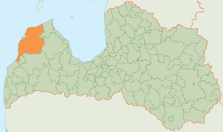
Ventspils Municipality is a municipality in Courland, Latvia. The municipality was formed in 2009 by merging Piltene town, Ance Parish, Jūrkalne Parish, Piltene rural community, Pope Parish, Puze Parish, Tārgale Parish, Ugāle Parish, Usma Parish, Užava Parish, Vārve Parish, Ziras Parish and Zlēkas Parish. It is administered from Ventspils city, which is not included within its limits.
Lénárddaróc is a village in Borsod-Abaúj-Zemplén County in northeastern Hungary.

Gorna Sushitsa is a village in Sandanski Municipality, in Blagoevgrad Province, Bulgaria. It is situated at the south-western foothills of the Pirin mountain range and is nestled in the Melnik Earth Pyramids.
Genionys is a village in Varėna district municipality, in Alytus County, in southeastern Lithuania. According to the 2001 census, the village has a population of 30 people.
Dachny, Dachnaya, or Dachnoye is the name of several rural localities in Russia.


