Related Research Articles

Saitama Prefecture is a landlocked prefecture of Japan located in the Kantō region of Honshu. Saitama Prefecture has a population of 7,338,536 and has a geographic area of 3,797 km2. Saitama Prefecture borders Tochigi Prefecture and Gunma Prefecture to the north, Nagano Prefecture to the west, Yamanashi Prefecture to the southwest, Tokyo to the south, Chiba Prefecture to the southeast, and Ibaraki Prefecture to the northeast.

Kazo is a city located in Saitama Prefecture, Japan. As of 1 January 2021, the city had an estimated population of 112,792 in 48,213 households and a population density of 850 persons per km2. The total area of the city is 133.30 square kilometres (51.47 sq mi). The city is noted for is known throughout Japan for the creation of koinobori, baseballs, kendo equipment, and Kazo-udon noodles.

Higashimatsuyama is a city located in Saitama Prefecture, Japan. As of 1 January 2021, the city had an estimated population of 90,456 in 41,124 households and a population density of 1400 persons per km2. The total area of the city is 65.33 km2 (25.22 sq mi).

Hanyū is a city located in Saitama Prefecture, Japan. As of 1 January 2021, the city had an estimated population of 54,304 in 23,487 households and a population density of 930 persons per km2. The total area of the city is 58.64 square kilometres (22.64 sq mi).

Ageo is a city located in Saitama Prefecture, Japan. As of February 1, 2024, the city had an estimated population of 230,041 in 107,555 households and a population density of 5100 persons per km2. The total area of the city is 45.51 square kilometres (17.57 sq mi).

Warabi is a city located in Saitama Prefecture, Japan. As of 1 February 2024, the city had an estimated population of 75,614 in 41,025 households and a population density of 15,000 persons per km2. The total area of the city is 5.11 square kilometres (1.97 sq mi). Warabi has the smallest area of any municipality in Japan, and highest population density outside of the special wards of Tokyo.

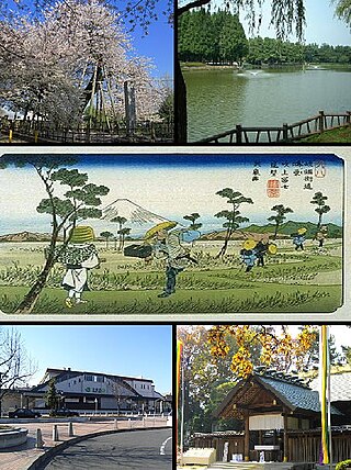
Asaka is a city located in Saitama Prefecture, Japan. As of 1 January 2021, the city had an estimated population of 143,195 and a population density of 7800 persons per km2. The total area of the city is 18.34 square kilometres (7.08 sq mi).

Niiza is a city in Saitama Prefecture, Japan. As of 1 January 2021, the city had an estimated population of 166,208 in 76,639 households and a population density of 7300 persons per km2. The total area of the city is 22.78 square kilometres (8.80 sq mi).
Kitamoto is a city in Saitama Prefecture, Japan. As of 1 January 2021, the city had an estimated population of 66,022 and a population density of 3300 persons per km2. The total area of the city is 19.82 square kilometres (7.65 sq mi).

Yashio is a city located in Saitama Prefecture, Japan. As of 1 January 2021, the city had an estimated population of 92,512 in 44,288 households and a population density of 5100 persons per km2. The total area of the city is 18.02 square kilometres (6.96 sq mi).

Fujimi is a city located in Saitama Prefecture, Japan. As of 1 January 2021, the city had an estimated population of 112,211 in 53,051 households and a population density of 5700 persons per km2. The total area of the city is 19.77 square kilometres (7.63 sq mi).

Ina is a town in Saitama Prefecture, Japan. As of 1 March 2021, the town had an estimated population of 44,928 in 18,907 households and a population density of 3000 persons per km². The total area of the town is 30.03 square kilometres (11.59 sq mi).

Ogawa is a town in Saitama Prefecture, Japan. As of 1 March 2021, the town had an estimated population of 28,971 in 12,989 households and a population density of 480 persons per km2. The total area of the town is 60.36 square kilometres (23.31 sq mi).

Kawajima is a town located in Saitama Prefecture, Japan. As of 1 March 2021, the town had an estimated population of 19,653 in 8105 households and a population density of 470 persons per km2. The total area of the town is 41.63 square kilometres (16.07 sq mi).

Ogano is a town located in Saitama Prefecture, Japan. As of 1 January 2021, the town had an estimated population of 11,192 in 4657 households and a population density of 65 persons per km2. The total area of the town is 171.26 square kilometres (66.12 sq mi). Parts of the town are within the borders of the Chichibu-Tama-Kai National Park.

Yorii is a town in Saitama Prefecture, Japan. As of 1 March 2021, the town had an estimated population of 32,851 in 14,689 households and a population density of 510 persons per km2. The total area of the town is 64.25 square kilometres (24.81 sq mi).

Miyashiro is a town located in Saitama Prefecture, Japan. As of 1 March 2021, the town had an estimated population of 33,823 in 15,234 households and a population density of 2100 persons per km2. The total area of the town is 15.95 square kilometres (6.16 sq mi).

Sugito is a town located in Saitama Prefecture, Japan. As of 1 March 2021, the town had an estimated population of 44,402 in 19,409 households and a population density of 1500 persons per km². The total area of the town is 30.03 square kilometres (11.59 sq mi).

Matsubushi is a town located in Saitama Prefecture, Japan. As of 1 March 2021, the town had an estimated population of 28,787 in 12,141 households and a population density of 1800 persons per km2. The total area of the town is 16.20 square kilometres (6.25 sq mi).

Saitama is the capital and largest city of Saitama Prefecture, Japan. Its area incorporates the former cities of Urawa, Ōmiya, Yono and Iwatsuki. It is a city designated by government ordinance. As of 1 February 2021, the city had an estimated population of 1,324,854, and a population density of 6,093 people per km². Its total area is 217.43 square kilometres (83.95 sq mi).
References
- Results from JanJan (in Japanese)
| | This Japanese elections-related article is a stub. You can help Wikipedia by expanding it. |