See also
| This disambiguation page lists articles associated with the title 27A. If an internal link led you here, you may wish to change the link to point directly to the intended article. |
27A may refer to :
| This disambiguation page lists articles associated with the title 27A. If an internal link led you here, you may wish to change the link to point directly to the intended article. |
Interstate 20 (I‑20) is a major east–west Interstate Highway in the Southern United States. I‑20 runs 1,539 miles (2,477 km) beginning near Kent, Texas, at I-10 to Florence, South Carolina, at I-95. Between Texas and South Carolina, I‑20 runs through northern Louisiana, Mississippi, Alabama, and Georgia. The major cities that I-20 connects to include Fort Worth, Texas; Dallas, Texas; Shreveport, Louisiana; Jackson, Mississippi; Birmingham, Alabama; Atlanta, Georgia; Augusta, Georgia; and Columbia, South Carolina.
Interstate 40 (I-40) is a major east–west Interstate Highway running through the south-central portion of the United States generally north of I-10, I-20 and I-30 but south of I-70. The western end is at I-15 in Barstow, California; its eastern end is at a concurrency of U.S. Route 117 (US 117) and North Carolina Highway 132 in Wilmington, North Carolina. It is the third-longest Interstate Highway in the United States, behind I-80 and I-90. Much of the western part of I-40, from Oklahoma City to Barstow parallels or overlays the historic US 66, east of Oklahoma City the route generally parallels US 64 and US 70. I-40 runs through or near many major cities including Albuquerque, New Mexico; Amarillo, Texas; Oklahoma City, Oklahoma; Little Rock, Arkansas; Memphis, Tennessee; Nashville, Tennessee; Knoxville, Tennessee; Greensboro, North Carolina; and Raleigh, North Carolina.

Delta is an American versatile family of expendable launch systems that has provided space launch capability in the United States since 1960. More than 300 Delta rockets have been launched with a 95% success rate. Only the Delta IV Heavy rocket remains in use as of August 22, 2019. Delta rockets are currently manufactured and launched by the United Launch Alliance.

U.S. Route 25 is a north–south United States highway that runs for 750 miles (1,210 km) from Brunswick, Georgia, to the Ohio state line in Covington, Kentucky.
U.S. Route 74 (US 74) is an east–west United States highway that runs for 515 miles (829 km) from Chattanooga, Tennessee to Wrightsville Beach, North Carolina. Predominantly in North Carolina, it serves as an important highway from the mountains to the sea, connecting the cities of Asheville, Charlotte and Wilmington.

The Rolls-Royce Avon was the first axial flow jet engine designed and produced by Rolls-Royce. Introduced in 1950, the engine went on to become one of their most successful post-World War II engine designs. It was used in a wide variety of aircraft, both military and civilian, as well as versions for stationary and maritime power.

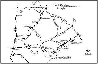
The Chattooga River is the main tributary of the Tugaloo River. Its headwaters are located southwest of Cashiers, North Carolina, and it stretches 57 miles (92 km) to where it has its confluence with the Tallulah River within Lake Tugalo, held back by the Tugalo Dam. The Chattooga and the Tallulah combine to make the Tugaloo River starting at the outlet of Lake Tugalo. The Chattooga begins in southern Jackson County, North Carolina, then flows southwestward between northwestern Oconee County, South Carolina, and eastern Rabun County, Georgia. The "Chattooga" spelling was approved by the US Board on Geographic Names in 1897.
The South Carolina State Highway System is the fourth largest state-maintained system of state highways in the country. It consists of Interstates, U.S. highways, state highways, and secondary roads, totaling approximately 41,500 miles (66,800 km).

The Appalachian Development Highway System (ADHS) is part of the Appalachian Regional Commission in the United States. It consists of a series of highway corridors in the Appalachia region of the eastern United States. The routes are designed as local and regional routes for improving economic development in the historically isolated region. It was established as part of the Appalachian Regional Development Act of 1965, and has been repeatedly supplemented by various federal and state legislative and regulatory actions. The system consists of a mixture of state, U.S., and Interstate routes. The routes are formally designated as "corridors" and assigned a letter. Signage of these corridors varies from place to place, but where signed are often done so with a distinctive blue-colored sign.

The McDonnell Douglas DC-9 is a single-aisle airliner designed by the Douglas Aircraft Company. After introducing its heavy DC-8 in 1959, Douglas approved the smaller, all-new DC-9 for shorter flights on April 8, 1963. The DC-9-10 first flew on February 25, 1965 and gained its type certificate on November 23, to enter service with Delta Air Lines on December 8. With five seats across in economy, it had two rear-mounted Pratt & Whitney JT8D turbofans under a T-tail for a cleaner wing, a two-person flight deck and built-in airstairs.
Interstate 440 (I-440), also known as the Raleigh Beltline, the Cliff Benson Beltline, or locally as just The Beltline, is an Interstate Highway in the US state of North Carolina. I-440 is a 16.4-mile-long (26.4 km) partial beltway that nearly encircles central Raleigh. I-440 begins in west Raleigh at an interchange with I-40, as a continuation of US Highway 64 /US 1 and traverses a primarily residential area in west Raleigh. The freeway makes a turn toward the east, crossing US 70, Six Forks Road, and Wake Forest Road. US 1 branches north off of I-440 at Capital Boulevard, becoming US 401/US 1. I-440 turns toward the southeast and follows a brief concurrency with US 64 Business before intersecting I-87/US 64/US 264. US 64 is concurrent with I-440 along the remainder of the road's southwesterly routing. Exit 16 is the last exit on I-440, where I-440 splits to become I-40 East and West.
The Bartram Trail follows the approximate route of 18th-century naturalist William Bartram’s southern journey from March 1773 to January 1777. Bartram explored much of the territory which is now the states of North and South Carolina, Georgia, Florida, Alabama, Mississippi, Louisiana and Tennessee.
Interstate 74 (I-74) is an Interstate Highway that is partially completed in the U.S. state of North Carolina. Currently in three distinct segments, when completed, it will traverse the state in a southeasterly direction from Virginia to South Carolina, connecting the cities of Winston-Salem, High Point, Asheboro, Rockingham, and Lumberton.
Interstate 40 (I-40) is a part of the Interstate Highway System that runs from Barstow, California to Wilmington, North Carolina. In North Carolina, I-40 enters the state along the Pigeon River Gorge, from Tennessee. Crossing the entire state, it connects the cities of Asheville, Statesville, Winston-Salem, Greensboro, Burlington, Durham and Raleigh before ending along U.S. Highway 117/North Carolina Highway 132 (US 117/NC 132) in Wilmington. The landscapes traversed by I-40 include the Blue Ridge Mountains, foothills of western North Carolina, suburban communities, the urban core of several Piedmont cities, along with eastern North Carolina farmland. At a total of 423.55 miles (681.64 km), it is the longest interstate highway in North Carolina. There are five auxiliary Interstates in the state related to I-40, as well as one business loop which currently runs through Winston-Salem. The route is labeled east-west for the entire route, however the eastern portion follows a much more north-south alignment.
In the U.S. state of North Carolina, Interstate 85 (I-85) scales the state for 234.6 miles (377.6 km) from the South Carolina border to the Virginia border. As the second-longest interstate in the state, it links the three largest metropolitan areas in North Carolina: Metrolina, the Piedmont Triad, and the Research Triangle. Nine of the twenty largest municipalities in the state lie along I-85, and it connects those cities to Richmond, Virginia to the north, and Upstate South Carolina and Atlanta, Georgia to the south.

The Boeing Everett Factory, in Everett, Washington, is an airplane assembly building owned by Boeing. Located on the north-east corner of Paine Field, it is the largest building in the world by volume at 13,385,378 m3 and covers 399,480 m2. This is the factory where the wide-body Boeing 747, 767, 777, and 787 are assembled.

The AJ10 is a hypergolic rocket engine manufactured by Aerojet Rocketdyne. It has been used to propel the upper stages of several launch vehicles, including the Delta II and Titan III. Variants were and are used as the service propulsion engine for the Apollo command and service module, in the Space Shuttle Orbital Maneuvering System, and on NASA's Orion spacecraft.

The Delta 1000 series was an American expendable launch system which was used to conduct eight orbital launches between 1972 and 1975. It was a member of the Delta family of rockets. Several variants existed, differentiated by a four digit numerical code.
Interstate 87 (I-87) is a partially completed Interstate Highway in the U.S. state of North Carolina, currently the shortest designated primary Interstate Highway at 12.9 miles (20.8 km). The completed portion is in eastern Wake County, between Raleigh and Wendell; the majority of the completed route is known as the Knightdale Bypass, while the remaining 3 miles (4.8 km) follows the Raleigh Beltline. It is planned to continue northeast through Rocky Mount, Williamston and Elizabeth City, ending in Norfolk, Virginia. It is signed as north-south, in keeping with the sign convention for most odd-numbered interstates, but the route goes primarily east-west, with the eastern direction aligning to the north designation.

North Carolina Highway 704 (NC 704) is a primary state highway in the U.S. state of North Carolina. The highway connects Madison with northern Stokes County and the Wentworth-Reidsville area.