
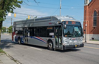
The Hamilton Street Railway commonly known as the HSR is a public transport agency in Hamilton, Ontario, Canada. The name is a legacy of the company's early period, when public transit in Hamilton was primarily served by streetcars. Although streetcars are no longer used in the city today, the HSR operates bus and paratransit services, with a ridership of 21 million passengers a year. The HSR uses the Presto card as its method of fare payment, allowing for connections with GO Transit and other transit systems in the Greater Toronto area.
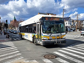
The Massachusetts Bay Transportation Authority (MBTA) operates 152 bus routes in the Greater Boston area. The MBTA has a policy objective to provide transit service within walking distance for all residents living in areas with population densities greater than 5,000 inhabitants per square mile (1,900/km2) within the MBTA's service district. Much of this service is provided by bus. In 2022, the system had a ridership of 83,623,600, or about 319,400 per weekday as of the first quarter of 2023.

The Boston-area trolleybus system formed part of the public transportation network serving Greater Boston in the U.S. state of Massachusetts. It opened on April 11, 1936, with a large network operating for the next quarter-century. Measured by fleet size, the Boston-area system was the third-largest trolleybus system in the United States at its peak, with only the Chicago and Atlanta systems having more trolleybuses than Boston's 463. After 1963, the only remaining portion was a four-route cluster operating from the Harvard bus tunnel at Harvard station, running through Cambridge, Belmont, and Watertown. The Massachusetts Bay Transportation Authority took over the routes in 1964.

As with many large cities, a large number of Boston-area streetcar lines once existed, and many continued operating into the 1950s. However, only a few now remain, namely the four branches of the Green Line and the Ashmont–Mattapan High-Speed Line, with only one running regular service on an undivided street.
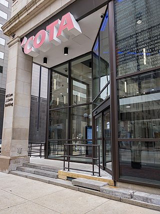
The Central Ohio Transit Authority is a public transit agency serving the Columbus metropolitan area, headquartered in Columbus, Ohio. It operates fixed-route buses, bus rapid transit, microtransit, and paratransit services.

Columbus Union Station was an intercity train station in Downtown Columbus, Ohio, near The Short North neighborhood. The station and its predecessors served railroad passengers in Columbus from 1851 until April 28, 1977.
The Columbus Streetcar was a proposed streetcar system to be located in and around Downtown Columbus, Ohio. Initially planned to run along High Street, the line would have run for 2.8 miles (4.5 km) and connected the Ohio State campus with the Franklin County Government Center. As of February 2009, the plan was indefinitely on hold. Discussion took place for a larger scale light rail system which would run along the streetcar route and also connect the northern part of the city to downtown. In 2014, the CBUS free circulator bus began operation on much of the proposed streetcar route.

Duboce and Church is a light rail stop on the Muni Metro J Church and N Judah lines, located in the Duboce Triangle neighborhood of San Francisco, California. Just east of the station, the two lines enter the Market Street subway. The stop originally opened with the 22 Fillmore line in 1895. The station has complex layout with two side platforms in the middle of Duboce Avenue for the N Judah, one side platform in the middle of Church Street for northbound J Church trains entering the Market Street subway, and two mini-high platforms at the subway portal which provides access to both lines for people with disabilities.

Public transit has taken numerous forms in Columbus, the largest city and capital of Ohio. Transit has variously used passenger trains, horsecars, streetcars, interurbans, trolley coaches, and buses. Current service is through the Central Ohio Transit Authority's bus system, numerous intercity bus companies, and through bikeshare, rideshare, and electric scooter services.

CMAX is a bus rapid transit (BRT) service in Central Ohio, operated by the Central Ohio Transit Authority (COTA). The line begins in Downtown Columbus, traveling northeast to Westerville. CMAX is Central Ohio's first bus rapid transit line; it began operation in 2018.

Campus Area Bus Service (CABS) is a free public transportation system at the Ohio State University's Columbus campus. The system consists of five bus routes that connect various points of Ohio State's campus, and the immediate off-campus area. The system connects with the Central Ohio Transit Authority's bus routes at several points.

The CBUS was a free downtown circulator bus in Columbus, Ohio. The service was operated by the Central Ohio Transit Authority. The CBUS service primarily traveled along High Street between the Brewery District and the Short North. The service had uniquely-branded 30-foot buses stopping at round "CBUS" signs. The service operated every 10–15 minutes, seven days per week. The service began operation on May 5, 2014.
The 10 E Broad / W Broad is a Central Ohio Transit Authority (COTA) bus service in Columbus, Ohio. The line operates on Broad Street, the city's main east-west thoroughfare.

The former Columbus Railway, Power & Light office is a historic building in the Milo-Grogan neighborhood of Columbus, Ohio. The two-story brick structure was designed by Yost & Packard and built in the 1890s as a transportation company office. The property was part of a complex of buildings, including a power plant, streetcar barn, and inspection shop. The office building, the only remaining portion of the property, was utilized as a transit office into the 1980s, and has remained vacant since then. Amid deterioration and lack of redevelopment, the site has been on Columbus Landmarks' list of endangered sites since 2014.

14 Mission is a trolleybus line operated by the San Francisco Municipal Railway. It serves Mission Street between the Ferry Plaza and Daly City.
LinkUS is a transportation initiative in Central Ohio, United States. The project aims to create approximately five rapid transit corridors to support the metro population of Columbus, the capital and largest city in Ohio.

Van Buren Street is a street in Chicago, in whose grid system it is 400 South. Named for President Martin Van Buren, it is adjacent to Jackson Boulevard named for Van Buren's associate Andrew Jackson.

