Albedo is the measure of the diffuse reflection of solar radiation out of the total solar radiation and measured on a scale from 0, corresponding to a black body that absorbs all incident radiation, to 1, corresponding to a body that reflects all incident radiation.

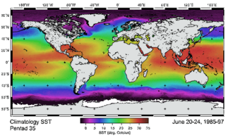
Satellite temperature measurements are inferences of the temperature of the atmosphere at various altitudes as well as sea and land surface temperatures obtained from radiometric measurements by satellites. These measurements can be used to locate weather fronts, monitor the El Niño-Southern Oscillation, determine the strength of tropical cyclones, study urban heat islands and monitor the global climate. Wildfires, volcanos, and industrial hot spots can also be found via thermal imaging from weather satellites.

Thermal radiation is electromagnetic radiation generated by the thermal motion of particles in matter. All matter with a temperature greater than absolute zero emits thermal radiation. Particle motion results in charge-acceleration or dipole oscillation which produces electromagnetic radiation.

Adaptive optics (AO) is a technology used to improve the performance of optical systems by reducing the effect of incoming wavefront distortions by deforming a mirror in order to compensate for the distortion. It is used in astronomical telescopes and laser communication systems to remove the effects of atmospheric distortion, in microscopy, optical fabrication and in retinal imaging systems to reduce optical aberrations. Adaptive optics works by measuring the distortions in a wavefront and compensating for them with a device that corrects those errors such as a deformable mirror or a liquid crystal array.

The Geostationary Earth Radiation Budget (GERB) is an instrument aboard EUMETSAT's Meteosat Second Generation geostationary satellites designed to make accurate measurements of the Earth Radiation Budget.

Radiative forcing is the change in energy flux in the atmosphere caused by natural and, or, anthropogenic factors of climate change as measured by watts / metre2. It is the scientific basis for the greenhouse effect on planets, and plays an important role in computational models of Earth's energy balance and climate. Changes to Earth's radiative equilibrium that cause temperatures to rise or fall over decadal periods are called climate forcings.

Clouds and the Earth's Radiant Energy System (CERES) is on-going NASA climatological experiment from Earth orbit. The CERES are scientific satellite instruments, part of the NASA's Earth Observing System (EOS), designed to measure both solar-reflected and Earth-emitted radiation from the top of the atmosphere (TOA) to the Earth's surface. Cloud properties are determined using simultaneous measurements by other EOS instruments such as the Moderate Resolution Imaging Spectroradiometer (MODIS). Results from the CERES and other NASA missions, such as the Earth Radiation Budget Experiment (ERBE), could lead to a better understanding of the role of clouds and the energy cycle in global climate change.

Earth's energy budget accounts for the balance between the energy that Earth receives from the Sun and the energy the Earth radiates back into outer space. Smaller energy sources, such as Earth's internal heat, are taken into consideration, but make a tiny contribution compared to solar energy. The energy budget also accounts for how energy moves through the climate system. Because the sun heats the equatorial tropics more than the polar regions, received solar irradiance is unevenly distributed. As the energy seeks equilibrium across the planet, it drives interactions in Earth's climate climate system, i.e., Earth's water, ice, atmosphere, rocky crust, and all living things. The result is Earth's climate.

The Advanced Very-High-Resolution Radiometer (AVHRR) instrument is a space-borne sensor that measure the reflectance of the Earth in five spectral bands that are relatively wide by today's standards. AVHRR instruments are or have been carried by the National Oceanic and Atmospheric Administration (NOAA) family of polar orbiting platforms (POES) and European MetOp satellites. The instrument scans several channels; two are centered on the red (0.6 micrometres) and near-infrared (0.9 micrometres) regions, a third one is located around 3.5 micrometres, and another two the thermal radiation emitted by the planet, around 11 and 12 micrometres.
Atmospheric sounding or atmospheric profiling is a measurement of vertical distribution of physical properties of the atmospheric column such as pressure, temperature, wind speed and wind direction, liquid water content, ozone concentration, pollution, and other properties. Such measurements are performed in a variety of ways including remote sensing and in situ observations.

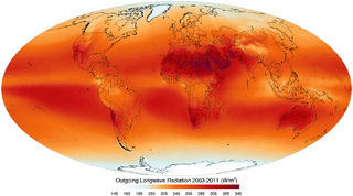
Outgoing Long-wave Radiation (OLR) is electromagnetic radiation of wavelengths from 3–100 μm emitted from Earth and its atmosphere out to space in the form of thermal radiation. It is also referred to as up-welling long-wave radiation and terrestrial long-wave flux, among others. The flux of energy transported by outgoing long-wave radiation is measured in W/m2. In the Earth's climate system, long-wave radiation involves processes of absorption, scattering, and emissions from atmospheric gases, aerosols, clouds and the surface.
An atmospheric radiative transfer model, code, or simulator calculates radiative transfer of electromagnetic radiation through a planetary atmosphere.
Atmospheric correction is the process of removing the effects of the atmosphere on the reflectance values of images taken by satellite or airborne sensors. Atmospheric effects in optical remote sensing are significant and complex, dramatically altering the spectral nature of the radiation reaching the remote sensor. There are various approaches and techniques to conducting atmospheric correction.
The Rapid Radiative Transfer Model (RRTM) is a validated, correlated k-distribution band model for the calculation of solar and thermal-infrared atmospheric radiative fluxes and heating rates. The Rapid Radiative Transfer Model for GCMs (RRTM-G) is an accelerated version of RRTM that provides improved efficiency with minimal loss of accuracy for application to general circulation models. The latter divides the solar spectrum into 14 bands within which a total of 112 pseudo-monochromatic calculations are performed, and in the thermal infrared 16 bands are used within which 140 pseudo-monochromatic calculations are performed. RRTM-G is used in a number of general circulation models worldwide, such as that of the European Centre for Medium-Range Weather Forecasts.
RTTOV - the fast radiative transfer model for calculations of radiances for satellite infrared or microwave nadir scanning radiometers.
The Community Radiative Transfer Model (CRTM) is a fast radiative transfer model for calculations of radiances for satellite infrared or microwave radiometers.
DART is a 3D radiative transfer model, designed for scientific research, in particular remote sensing. Developed at CESBIO since 1992, DART model was patented in 2003. It is freeware for scientific activities.

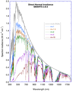
The Simple Model of the Atmospheric Radiative Transfer of Sunshine (SMARTS) is a computer program designed to evaluate the surface solar irradiance components in the shortwave spectrum under cloudless conditions. The program, written in FORTRAN, relies on simplifications of the equation of radiative transfer to allow extremely fast calculations of the surface irradiance. The irradiance components can be incident on a horizontal, a fixed-tilt or a 2-axis tracking surface. SMARTS can be used for example to evaluate the energy production of solar panels under variable atmospheric conditions. Many other applications are possible.

ARTS is a widely used atmospheric radiative transfer simulator for infrared, microwave, and sub-millimeter wavelengths. While the model is developed by a community, core development is done by the University of Hamburg and Chalmers University, with previous participation from Luleå University of Technology and University of Bremen.
Lorraine Remer is research professor at University of Maryland, Baltimore County known for her work on developing algorithms to study aerosol particles using satellites with a particular focus on how aerosols impact climate processes.


