The AN/APS-2, originally known as ASG (air-surface, model G), was a surface search radar developed by Philco originally for use in US Coast Guard blimps to detect German submarines. It proved better than several similar models then being built, and was ordered by the RAF Coastal Command where it was known as ASV Mark V. It was used primarily on British Liberator GR bombers, where they were instrumental in closing the Mid-Atlantic Gap and the subsequent destruction of the German U-boat fleet in May/June 1943.
In the post-war era, many APS-2s were passed off for other services. Some of the USA's first weather radars were modified APS-2F radars. [1]
The US Weather Bureau (precursor to the National Weather Service) obtained 25 AN/APS-2F aircraft radars from the Navy in 1946. The radars were modified for meteorological use and put into operation at a rate of about five per year. The modifications were performed by the Weather Bureau, which called the modified APS-2F radars WSR-1s, -1As, -3s, and -4s. [1]
Three particularly severe weather events in the spring of 1953 led to the formation of a Texas Tornado Warning Network. Major cities in Texas were approached for funds (some from the private sector and some from the public sector) to modify and install the APS-2Fs (as models WSR-1, -1A, -3, and -4) in Weather Bureau offices. The Weather Bureau agreed to operate and maintain the radars and provide warnings to the public when confirmed sightings were made. Formation of the network began at a kickoff meeting held on June 24, 1953. [2] Approximately six years were required before the network attained full strength; about 17 radars were modified and installed under this joint effort by local government, state, and federal agencies, and a university. [1]
The modified APS-2F at Texas A&M University, although not formally a part of the Texas Tornado Warning Network, was used at least once for warning purposes, on April 5, 1956. [1]
After 1956, the task of modifying the APS-2F radars so they could be fielded as WSR-1s, -1As, -3s, and -4s was transferred to Weather Bureau headquarters, which had to relocate some antennas that had been mounted in locations where they were difficult to maintain. At the height of the program in April 1975, 82 of the WSR-1s, -1As, -3s, and -4s were operational. A few were replaced by the WSR-57, but most continued in service until replaced by the WSR-74C over an extended period from 1976 to 1980. None are in service today. [1]
These radars had S-band wavelengths, so attenuation by rain was almost entirely avoided; [4] however, detection of light rain and snow was minimal due to system performance limitations. [1]
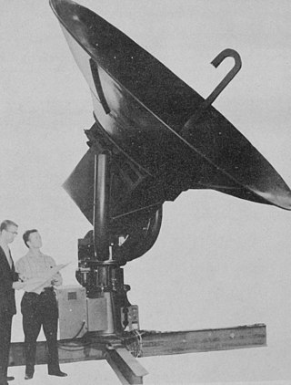
Modifications made to the radars included a new antenna pedestal to support a 6 ft (1.8 m) parabolic reflector, a rack-mounted PPI and A-scope, and a fiberglass radome to protect the antenna and allow operation without wind and ice loading. [1]

NEXRAD or Nexrad is a network of 159 high-resolution S-band Doppler weather radars operated by the National Weather Service (NWS), an agency of the National Oceanic and Atmospheric Administration (NOAA) within the United States Department of Commerce, the Federal Aviation Administration (FAA) within the Department of Transportation, and the U.S. Air Force within the Department of Defense. Its technical name is WSR-88D.

WSR-74 radars were Weather Surveillance Radars designed in 1974 for the National Weather Service. They were added to the existing network of the WSR-57 model to improve forecasts and severe weather warnings. Some have been sold to other countries like Australia, Greece, and Pakistan.
WSR-57 radars were the primary weather surveillance radar used by the United States for over 35 years. The National Weather Service operated a network of this model radar across the country, watching for severe weather.

From May 2 to 8, 1999, a large tornado outbreak took place across much of the Central and parts of the Eastern United States, as well as southern Canada. During this week-long event, 152 tornadoes touched down in these areas. The most dramatic events unfolded during the afternoon of May 3 through the early morning hours of May 4 when more than half of these storms occurred. Oklahoma experienced its largest tornado outbreak on record, with 70 confirmed. The most notable of these was the F5 Bridge Creek–Moore tornado which devastated Oklahoma City and suburban communities. The tornado killed 36 people and injured 583 others; losses amounted to $1 billion, making it the first billion-dollar tornado in history. Overall, 50 people lost their lives during the outbreak and damage amounted to $1.4 billion. For these reasons, the outbreak is known in Oklahoma as the May 3rd outbreak or the Oklahoma tornado outbreak of 1999.

Weather radar, also called weather surveillance radar (WSR) and Doppler weather radar, is a type of radar used to locate precipitation, calculate its motion, and estimate its type. Modern weather radars are mostly pulse-Doppler radars, capable of detecting the motion of rain droplets in addition to the intensity of the precipitation. Both types of data can be analyzed to determine the structure of storms and their potential to cause severe weather.

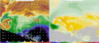
A hook echo is a pendant or hook-shaped weather radar signature as part of some supercell thunderstorms. It is found in the lower portions of a storm as air and precipitation flow into a mesocyclone, resulting in a curved feature of reflectivity. The echo is produced by rain, hail, or debris being wrapped around the supercell. It is one of the classic hallmarks of tornado-producing supercells. The National Weather Service may consider the presence of a hook echo coinciding with a tornado vortex signature as sufficient to justify issuing a tornado warning.

The Aggie Doppler Radar (ADRAD) is a Doppler weather radar located on the roof of the Eller Oceanography & Meteorology Building on the Texas A&M University campus in College Station, Texas.

The Canadian weather radar network consists of 33 weather radars spanning Canada's most populated regions. Their primary purpose is the early detection of precipitation, its motion and the threat it poses to life and property.

The WSR-1 or Weather Surveillance Radar-1 was one of the first weather radars and the first used by a civilian organization in the US. The WSR-1 series was a modified version of the AN/APS-2F radar, which the Weather Bureau acquired from the Navy. The WSR-1A, WSR-3, and WSR-4 were also variants of this radar. The first WSR-1 in the USA was at Washington National Airport in Washington, D.C., in 1947, and the last WSR-3 was retired by 1978.
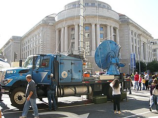
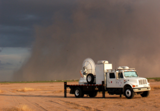
Doppler on Wheels is a fleet of X-band and C-band mobile and quickly-deployable truck-borne radars which are the core instrumentation of the Flexible Array of Radars and Mesonets affiliated with the University of Alabama Huntsville and led by Joshua Wurman, with the funding partially provided by the National Science Foundation (NSF), as part of the "Community Instruments and Facilities," (CIF) program. The DOW fleet and its associated Mobile Mesonets and deployable weather stations have been used throughout the United States since 1995, as well as occasionally in Europe and Southern America. The Doppler on Wheels network has deployed itself through hazardous and challenging weather to gather data and information that may be missed by conventional stationary radar systems.

Joseph G. Galway, was an American meteorologist pioneering in the fields of severe convective storm forecasting and research. He was one of the first forecasters for the Severe Local Storms Unit and the National Severe Storms Forecast Center, and developed widely used synoptic predictors associated with severe thunderstorms and tornadoes, such as the jet streak and lifted index.
Neil Burgher Ward was an American meteorologist who is credited as the first scientific storm chaser, developing ideas of thunderstorm and tornado structure and evolution as well as techniques for forecasting and severe weather intercept. He also was a pioneering developer of physical models of tornadoes, first at his home, then at the National Severe Storms Laboratory (NSSL) in Norman, Oklahoma. He significantly furthered the modern scientific understanding of atmospheric vortices, particularly tornadoes.

Convective storm detection is the meteorological observation, and short-term prediction, of deep moist convection (DMC). DMC describes atmospheric conditions producing single or clusters of large vertical extension clouds ranging from cumulus congestus to cumulonimbus, the latter producing thunderstorms associated with lightning and thunder. Those two types of clouds can produce severe weather at the surface and aloft.

A tornadic vortex signature, abbreviated TVS, is a Pulse-Doppler radar weather radar detected rotation algorithm that indicates the likely presence of a strong mesocyclone that is in some stage of tornadogenesis. It may give meteorologists the ability to pinpoint and track the location of tornadic rotation within a larger storm, and is one component of the National Weather Service's warning operations.

A hail spike or three body scatter spike (TBSS) is an artifact on a weather radar display indicative of large hail. They are identified by a spike of weak reflectivity echoes that extend out from a thunderstorm, and away from the radar site.

National Weather Service Lincoln, Illinois also known as National Weather Service Central Illinois is a weather forecast office responsible for monitoring weather conditions for 35 counties in Central and Southeastern Illinois. The Central Illinois office initially consisted of two forecast offices in Peoria and Springfield until the current location in Lincoln became the sole local forecast office in 1995. Federal meteorology offices and stations in the region date back to the 19th century when the Army Signal Service began taking weather observations using weather equipment at the Springer Building in Springfield. Since that time the presence of the National Weather Service greatly increased with the installation of new weather radars, stations and forecast offices. The current office in Lincoln maintains a WSR-88D (NEXRAD) radar system, and Advanced Weather Interactive Processing System (AWIPS) that greatly improve forecasting in the region. Lincoln is in charge of weather forecasts, warnings and local statements as well as aviation weather.

The National Weather Service Amarillo, Texas, is a weather forecast office that serves 23 counties in the Texas and Oklahoma Panhandles by providing weather forecasts for the many communities it serves as well as airports in Guymon, Dalhart, and Amarillo. The office was established on January 1, 1892, only 5 years after the city of Amarillo was founded. The office operates a WSR-88D (NEXRAD) radar and a number of ASOS sensor suites in order to monitor the latest weather conditions. An AWIPS system is used by the office to produce forecasts, warnings, and advisories.
The Shared Mobile Atmospheric Research and Teaching Radar, colloquially known as SMART-R or SR, is a mobile Doppler weather radar platform operated and created by University of Oklahoma (OU) with aide from Texas A&M and Texas Tech University in 2001.

Project NIMROD was a meteorological field study of severe thunderstorms and their damaging winds conducted by the National Center for Atmospheric Research (NCAR). It took place in the Greater Chicago area from May 15 to June 30, 1978. Data collected was from single cell thunderstorms as well as mesoscale convective systems, such as bow echoes. Using Doppler weather radars and damage clues on the ground, the team studied mesocyclones, downbursts and gust fronts. NIMROD was the first time that microbursts, very localized strong downdrafts under thunderstorms, were detected; this helped improve airport and public safety by the development of systems like the Terminal Doppler Weather Radar and the Low-level windshear alert system.
Starting in the mid-1900s, mobile radar vehicles were being used for academic and military research. In the late 1900s, mobile doppler weather radars were designed and created with the goal to study atmospheric phenomena.