Abele (village)

Last updated
View on Abele Abele - View 1.jpg
View on Abele

Abele (also spelled Abeele) is a small village or hamlet in the city of Poperinge, in the Belgian province of West Flanders. The village is located on the territory of Poperinge proper and its "deelgemeente" Watou, but is also partly located on French territory. Abele has about 600 inhabitants, of whom about 100 are French. The main street coincides with the border between Belgium and France, so houses located on different sides of the street are located in a different country.

Contents

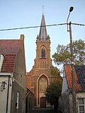
The church of Abele is located on French territory, but the services are organized by the Roman Catholic Diocese of Bruges. The Kerkfabriek  [ nl ] of Watou and the local authorities of Boeschepe are responsible for its maintenance.

Abele used to be an import border crossing. In 1713, a tollhouse was set up, but it disappeared during the French Revolution. The old Belgian customs office was renovated and now serves as a retro-café with a small exhibition.

Abeele Aerodrome Military Commonwealth War Graves Commission Cemetery is outside the village, on the site of a World War I military airfield.

Related Research Articles

Neutral Moresnet Former condominium between what is now Belgium and Germany

Neutral Moresnet was a small Belgian–Prussian condominium in western Europe that existed from 1816 to 1920 and was administered jointly by the United Kingdom of the Netherlands and the Kingdom of Prussia. It was 1 mile (1.6 km) wide and 3 miles (4.8 km) long, with an area of 900 acres (360 ha). After 1830, the territory's northernmost border point at Vaalserberg connected it to a quadripoint shared additionally with the Dutch Province of Limburg, the Prussian Rhine Province, and the Belgian Liège Province. Its former location is represented presently by the Three-Country Point, the meeting place of the borders of Belgium, Germany, and the Netherlands.

De Panne Municipality in Flemish Community, Belgium

De Panne is a town and a municipality located on the North Sea coast of the Belgian province of West Flanders. There it borders France, which implies that it is the westernmost location of Belgium. It is one of the most popular resort town destinations within Belgium.

Heuvelland Municipality in Flemish Community, Belgium

Heuvelland is a municipality located in the Belgian province of West Flanders. The municipality comprises the villages of Dranouter, Kemmel, De Klijte, Loker, Nieuwkerke, Westouter, Wijtschate and Wulvergem. Heuvelland is a thinly populated rural municipality, located between the small urban centres of Ypres and Poperinge and the metropolitan area of Kortrijk-Lille along the E17. On 1 January 2006 Heuvelland had a total population of 8,217. The total area is 94.24 km² which gives a population density of 87 inhabitants per km². The name heuvelland is Dutch meaning "hill country", as the municipality is characterized by the different hills on its territory.

Poperinge Municipality in Flemish Community, Belgium

Poperinge is a municipality located in the Belgian province of West Flanders, Flemish Region, and has a history going back to medieval times. The municipality comprises the city of Poperinge proper and surrounding villages. The area is famous for its hops and lace.

City of Brussels Capital of Belgium

The City of Brussels is the largest municipality and historical centre of the Brussels-Capital Region, and the capital of Belgium. Besides the strict centre, it also covers the immediate northern outskirts where it borders municipalities in Flanders. It is the administrative centre of the European Union, thus often dubbed, along with the region, the EU's capital city.

Maubeuge Commune in Hauts-de-France, France

Maubeuge is a commune in the Nord department in northern France.

Abeele Aerodrome Military Commonwealth War Graves Commission Cemetery Cemetery in West Flanders, Belgium

Abeele Aerodrome Military Cemetery is a Commonwealth War Graves Commission (CWGC) burial ground for the dead of the First World War located in the Ypres Salient on the Western Front.

Ploegsteert

Ploegsteert is a village in Belgium in the municipality of Comines-Warneton in the Hainaut province and is the most westerly settlement of Wallonia. It is approximately 2 kilometres (1.2 mi) north of the French border. Created in 1850 on part of the territory of Warneton, it includes the hamlet of Le Bizet, which is the border with France. It is largely francophone, with facilities for Dutch speakers.

Roesbrugge-Haringe Deelgemeente in West Flanders, Belgium

Roesbrugge-Haringe is a place in the Belgian province of West Flanders. It is a part of the municipality of Poperinge. Roesbrugge-Haringe consists of two small rural villages, Roesbrugge and Haringe, located in the north western region of Poperinge. Roesbrugge, the largest of both villages, is located along the Yser river. Haringe is located one kilometer to the south west of Roesbrugge, close to the French border.

Roesbrugge

Roesbrugge is a small rural village in the Belgian province of West Flanders. Roesbrugge is the larger of two villages that make up the "deelgemeente" Roesbrugge-Haringe in the municipality of Poperinge. Roesbrugge is located in the northwestern part of Poperinge and in the northern part of Roesbrugge-Haringe. The town center is located along the Yser river. An old branch of this river, the Dode IJzer makes up the northern border of the town center. The built-up area extends across the Dode IJzer into the hamlet Beveren-Kalsijde, a settlement on the territory of Beveren-aan-de-IJzer in the municipality of Alveringem. The small village of Haringe is located one kilometer to the southwest of Roesbrugge; both make up the deelgemeente Roesbrugge-Haringe.

Wervicq-Sud Commune in Hauts-de-France, France

Wervicq-Sud is a commune in the Nord department of northern France, near the border with Belgium. Wervicq-Sud is one of the oldest villages still existent, dating back to Roman times.

Brandhoek

Brandhoek is a small hamlet in Belgium situated between Ypres, Vlamertinge and Poperinge just off the N308/N38.

Langemark Deelgemeente in West Flanders, Belgium

Langemark is a village in the Belgian province of West Flanders, and a subdivision of the municipality of Langemark-Poelkapelle. The village has about 5,000 inhabitants. Besides the village center, there are also three smaller hamlets on the territory, Madonna, Bikschote and Saint-Julien/Sint-Juliaan.

Watou

Watou is a village in the Belgian province of West Flanders and a district of the town of Poperinge. The village has a population of 1,900. It lies on the border with France. The hamlet Abele is part of Watou. Poperinge is situated on the border with the hamlet of Sint-Jan-ter-Biezen.

Reningelst Deelgemeente in West Flanders, Belgium

Reningelst is a rural village in the Belgian province of West Flanders, and a "deelgemeente" of the municipality Poperinge. The village has about 1405 inhabitants.

Dranouter

Dranouter is a village and a deelgemeente in the municipality of Heuvelland in West Flanders, Belgium. Dranouter was an independent municipality before the 1977 local government reforms. Since then, it has been part of the municipality of Heuvelland. The area of the deelgemeente Dranouter is 10.73 km². The Dranouter Folk Festival is organised in the village every year. The postal code is 8951.

Jagdstaffel 28

Royal Württemberg Jagdstaffel 28, commonly abbreviated to Jasta 28, was a "hunting group" of the Luftstreitkräfte, the air arm of the Imperial German Army during World War I. As one of the original German fighter squadrons, the unit would score 100 verified aerial victories. The Jasta would pay a blood price for its success: nine pilots killed in action, three wounded in action, one injured in a collision, and one prisoner of war.

Vlamertinge Town in Flanders, Belgium

Vlamertinge is a village in the Belgian province of West Flanders and a borough of the city of Ypres. The village center of Vlamertinge lies just outside the city center of Ypres, along the main road N38 to the nearby town of Poperinge.

Lijssenthoek Military Cemetery

Lijssenthoek Military Cemetery is a Commonwealth War Graves Commission (CWGC) burial ground for the dead of the First World War in the Ypres Salient on the Western Front. After Tyne Cot, it is the second largest cemetery for Commonwealth forces in Belgium. Lijssenthoek Military Cemetery is located near Poperinge in the province of West Flanders. Most of those buried in the cemetery are war casualties who had been wounded near Ypres and later died in the four large Allied casualty clearing stations located in this area.

Reniere & Depla

Reniere & Depla is a Belgian artist duo, consisting of Paul Reniere and Martine Depla. Together they paint primarily with acrylic paint on canvas and wood panel. They have curated exhibitions in Belgium and France, showing the works of [Berlinde De Bruyckere], [Hans op de Beeck], and other celebrated Belgian artists. In 2018, they organised the first edition of Art Autun, a biennale of contemporary art in Autun. Their common career as artists began in 1995. They live and work in [Watou] and Autun. Like a growing group of contemporary artists they use photography as source material for their work.

References

    Coordinates: 50°49′20″N2°40′08″E / 50.8222°N 2.669°E / 50.8222; 2.669