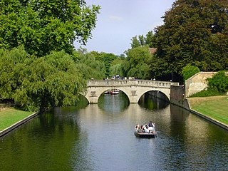
The River Cam is the main river flowing through Cambridge in eastern England. After leaving Cambridge, it flows north and east before joining the River Great Ouse to the south of Ely, at Pope's Corner. The total distance from Cambridge to the sea is about 40 mi (64 km) and is navigable for punts, small boats, and rowing craft. The Great Ouse also connects to England's canal system via the Middle Level Navigations and the River Nene. In total, the Cam runs for around 69 kilometres (43 mi) from its furthest source to its confluence with the Great Ouse.
Llandrinio is a small village and community in Montgomeryshire, Powys, Wales, close to the Wales-England border. It is situated on the B4393 road which travels from the village of Ford, Shropshire to Lake Vyrnwy. The community, Llandrinio and Arddleen includes Arddlin and a small part of Four Crosses, Powys.

The River Dwyryd (Welsh: Afon Dwyryd, meaning a river of two fords, is a river in Gwynedd, Wales which flows principally westwards; draining to the sea into Tremadog Bay, south of Porthmadog.
The ceremonial county of Lincolnshire is the second largest of the English counties and one that is predominantly agricultural in character. Despite its relatively large physical area, it has a comparatively small population. The unusually low population density that arises gives the county a very different character from the much more densely populated an urbanised counties of south-east and northern England, and is, in many ways, key to understanding the nature of the county.

Caer Caradoc is a hill in the English county of Shropshire. It overlooks the town of Church Stretton and the village of All Stretton and offers panoramic views to the north towards the Wrekin, east to Wenlock Edge, and west over the nearby Long Mynd. It is not to be confused with another hillfort of the same name 1 km west of Chapel Lawn near Bucknell.

The River Flit is a short river in Bedfordshire, England. Its name is not ancient, but rather a back formation from Flitton which originally meant that the river was spelt with as Flitt rather than Flit.

Lugwardine is a village and civil parish in Herefordshire, England, to the east of Hereford. It lies on the north-east bank of the River Lugg, which gives the village its name. The population of the civil parish taken at the 2011 Census was 1,721.
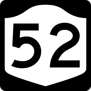
New York State Route 52 (NY 52) is a 108.72-mile-long (174.97 km) state highway in the southeastern part of the state. It generally runs from west to east through five counties, beginning at the Pennsylvania state line in the Delaware River near Narrowsburg, crossing the Hudson River on the Newburgh–Beacon Bridge, and ending in Carmel. NY 52 and NY 55, both major east–west routes of the Mid-Hudson Region, run parallel to each other, intersecting in downtown Liberty.

Ffridd Gate was a station on the Corris Railway in Merioneth, Wales, UK. It was built at the level crossing over the B4404 road to Llanwrin, near the hamlet of Fridd. A small hamlet also grew up around the station and a nearby (pre-existent) toll-house. The hamlet and former station are near to the confluence of the Afon Dulas and the River Dyfi, around 2+1⁄4 miles (3.6 km) west of the village of Llanwrin and 1 mile (1.6 km) north of the town of Machynlleth.

Hunningham is a small village and civil parish in Warwickshire, England. It is 3 miles to the north-east of Leamington Spa, within the Radford Semele ward. In 2005 the village population was 198. Hunningham village is part of the Manor of Hunningham. The history of the Manor of Hunningham is of great interest because it has been documented continuously for a thousand years, from the time of the Domesday Book, written in 1086, to the present day. The village public house is the Red Lion, which was refurbished in 2007 after flooding by the River Leam. There is local nature reserve where endangered species live. It also has a cricket club.

The A445 road is a road in Warwickshire, England. It runs between the town of Warwick and the A45, also passing through the north of Leamington Spa. The road provides the major link between Leamington/Warwick and north-east Warwickshire, including Rugby and the M45/M1 motorways. The M45/M1 provided the major route to London until the early 1990s but have now been superseded by the M40, which passes to the south of the Leamington/Warwick conurbation.

Stoke Rivers is a small village five miles north-east of Barnstaple, in Devon, England. The village historically formed part of Shirwell Hundred and for ecclesiastical purposes falls within the Shirwell Deanery. The parish of Stoke Rivers comprises the village itself as well as several scattered farmsteads. There is also the medieval parish church of St. Batholomew and a small Baptist church.

The River Fergus is a river within the Shannon River Basin which flows in County Clare, Ireland. The river begins at Lough Fergus in north Clare and flows into the Shannon Estuary. The source is at Lough Fergus in the townland of Kilmore North.
A7 was a club in New York City that between 1981 and 1984, was a main location of the New York hardcore scene. The tiny space was located on the southeast corner of East 7th Street and Avenue A in Manhattan's East Village. The venue hosted fast punk bands such as The Stimulators or The Violators, and slowly a hardcore scene of initially about 100 persons formed around the club which spawned bands like The Abused, Agnostic Front, Antidote, Cro-Mags, Heart Attack, Kraut, The Mob or Urban Waste who played the A7 regularly, some of them weekly.

Afon Cych is a tributary of the River Teifi in south-west Wales. It is 13 km long, passes through a number of small settlements on the border between Pembrokeshire and Carmarthenshire, and is significant in Welsh legend.
The Nazko First Nation is a First Nations government of the Dakelh people in the north-central Interior of British Columbia. Its reserves are located around the community of Nazko, British Columbia, which is 120 km west of Quesnel and southwest of Prince George.

Cwmystwyth is a village in Ceredigion, Wales near Devil's Bridge, and Pont-rhyd-y-groes.
Boughrood is a village in the community of Glasbury in Powys, Wales.

Ffostrasol is a small village in the south of Ceredigion, Wales. It is located on the A486 between Synod Inn and Llandysul, and it forms part of the parish of Troedyraur. The village lies on a rural crossroad connecting it with the nearby village of Plwmp to the north, Synod Inn to the north east, Newcastle Emlyn to the south west, and Llandysul to the south east.

The Afon Brân is a tributary of the River Towy in mid Wales. Its headwaters rise in Irfon Forest in the northeastern corner of Carmarthenshire as the Cynnant Fawr and Afon Lwynor and the river assumes the name of Afon Brân at their confluence to the north of the village of Cynghordy. Its major tributary is the Afon Gwydderig which joins it at Llandovery. Other tributaries include the Nant Bargod, Cynnant Fach, Afon Gwyddon, Nant Hirgwm, Nant Cwm-neuadd, Bawddwr and Afon Crychan with its own minor tributary the Afon Dulais.