
Oglala Lakota County is a county in southwestern South Dakota, United States. As of the 2020 census, the population was 13,672. Oglala Lakota County does not have a functioning county seat; Hot Springs in neighboring Fall River County serves as its administrative center. The county was created as a part of the Dakota Territory in 1875, although it remains unorganized. Its largest community is Pine Ridge.

Minnehaha County is a county on the eastern border of the state of South Dakota. As of the 2020 census, the population was 197,214, making it the state's most populous county. It contains over 20% of the state's population. Its county seat is Sioux Falls, South Dakota's largest city. The county was created in 1862 and organized in 1868. Its name was derived from the Sioux word Mnihaha, meaning "rapid water," or "waterfall".

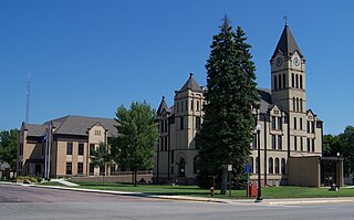
Marshall County is a county in the U.S. state of South Dakota. As of the 2020 census, the population was 4,306. Its county seat is Britton. The county was created on May 2, 1885, and was named for Marshall Vincent, who homesteaded near Andover, South Dakota.
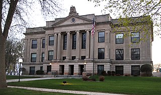
Lincoln County is a county in the U.S. state of South Dakota. As of the 2020 census, the population was 65,161, making it the third-most populated county in the state. Its county seat is Canton. The county was named for Abraham Lincoln, 16th President of the United States.

Morton County is a county in the U.S. state of North Dakota. As of the 2020 census, the population was 33,291, making it the sixth-most populous county in North Dakota. Its county seat is Mandan. Morton County is included in the Bismarck, ND, Metropolitan Statistical Area.
Lincoln County is a county in the U.S. state of Minnesota. As of the 2020 census, the population was 5,640. Its county seat is Ivanhoe.
Watertown is a city in and the county seat of Codington County, South Dakota, United States. Watertown is home to the Redlin Art Center which houses many of the original art works produced by Terry Redlin, one of America's most popular wildlife artists. Watertown is located between Pelican Lake and Lake Kampeska, from which Redlin derived inspiration for his artwork.

Yankton is a city in and the county seat of Yankton County, South Dakota, United States.

Fort Abraham Lincoln State Park is a North Dakota state park located 7 miles (11 km) south of Mandan, North Dakota, United States. The park is home to the replica Mandan On-A-Slant Indian Village and reconstructed military buildings including the Custer House.

The South Dakota Supreme Court is the highest court in the state of South Dakota. It is composed of a chief justice and four associate justices appointed by the governor. One justice is selected from each of five geographic appointment districts. Justices face a nonpolitical retention election three years after appointment and every eight years after that. The justices also select their own chief justice.

The Great Sioux Reservation initially set aside land west of the Missouri River in South Dakota and Nebraska for the use of the Lakota Sioux, who had dominated this territory. The reservation was established in the Fort Laramie Treaty of 1868. It included all of present-day western South Dakota and modern Boyd County, Nebraska. This area was established by the United States as a reservation for the Teton Sioux, also known as the Lakota: the seven western bands of the "Seven Council Fires".
The Drift Prairie is a geographic region of North Dakota and South Dakota.

The Spirit Lake Tribe is a federally recognized tribe based on the Spirit Lake Dakota Reservation located in east-central North Dakota on the southern shores of Devils Lake. It is made up of people of the Pabaksa (Iháŋkthuŋwaŋna), Sisseton (Sisíthuŋwaŋ) and Wahpeton (Waȟpéthuŋwaŋ) bands of the Dakota tribe. Established in 1867 in a treaty between Sisseton-Wahpeton Bands and the United States government, the reservation, at 47°54′38″N98°53′01″W, consists of 1,283.777 square kilometres (495.669 sq mi) of land area, primarily in Benson and Eddy counties. Smaller areas extend into Ramsey, Wells and Nelson counties.

The US–Dakota War of 1862, also known as the Sioux Uprising, the Dakota Uprising, the Sioux Outbreak of 1862, the Dakota Conflict, or Little Crow's War, was an armed conflict between the United States and several bands of eastern Dakota also known as the Santee Sioux. It began on August 18, 1862, at the Lower Sioux Agency along the Minnesota River in southwest Minnesota.
The Dakota are a Native American tribe and First Nations band government in North America. They compose two of the three main subcultures of the Sioux people, and are typically divided into the Eastern Dakota and the Western Dakota.
The Department of the Northwest was an U.S. Army Department created September 6, 1862 to put down the Sioux uprising in Minnesota. Major General John Pope was made commander of the Department. At the end of the Civil War the Department was redesignated the Department of Dakota. Immediately upon arriving in St. Paul General Pope sent letters to the Governors of Iowa and Wisconsin for additional troops to assist the 5th Minnesota Infantry Regiment. From Iowa he got the 27th Iowa Infantry Regiment and from Wisconsin he received the 25th Wisconsin Infantry Regiment. Both quickly crossed the border to assist with the uprising. The 25th Wisconsin was in Minnesota three months and the 27th Iowa was there a month before both headed south. After they departed, the Minnesota District would be garrisoned by Minnesota units: 5th, 6th, 7th, 8th, 9th, 10th Infantry Regiments, 1st and 2nd Minnesota Cavalry Regiments plus Minnesota Independent Cavalry Battalion as well as the 3rd Minnesota Light Artillery Battery. In 1864 companies of the 30th Wisconsin Infantry Regiment would see service in the Minnesota and Dakota Districts too.

Lake Herman State Park is a South Dakota state park in Lake County, South Dakota in the United States. The park is open for year-round recreation including camping, swimming, fishing, hiking and boating on the 1,350-acre Lake Herman. There are 72 campsites which feature electric hook-ups and 4 cabins.
Roy Lake State Park is a South Dakota state park in Marshall County, South Dakota in the United States. The park is divided in two sections on Roy Lake, and is open for year-round recreation including camping, beaches, swimming, fishing, hiking and boating. The Roy Lake Resort & Lodge is located in the park. Boat ramps are available and visitors can rent boats from the resort.
Hillhead is an unincorporated community in Marshall County, in the U.S. state of South Dakota. Hillhead is located approximately 2 kilometers northeast of Abraham Lake.

