
Bacup is a town in the Rossendale Borough in Lancashire, England, in the South Pennines close to Lancashire's boundaries with West Yorkshire and Greater Manchester. The town is in the Rossendale Valley and the upper Irwell Valley, 4 miles (6.4 km) east of Rawtenstall, 6 miles (9.7 km) north of Rochdale, and 7 miles (11 km) south of Burnley. At the 2011 Census, Bacup had a population of 13,323.
The City of Milton Keynes is a unitary authority area with both borough and city status, in Buckinghamshire. It is the northernmost district of the South East England Region. The borough abuts Bedfordshire, Northamptonshire and the remainder of Buckinghamshire.

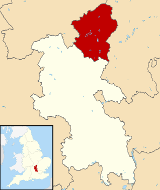
Rossendale is a district with borough status in Lancashire, England, located along the River Irwell and spanning a large valley. It is located south of Burnley and east of Blackburn. The borough borders Greater Manchester to the south and borders the boroughs of Bolton, Bury and Rochdale.
Hyndburn is a local government district with borough status in Lancashire, England. Its council is based in Accrington and covers the outlying towns of Clayton-le-Moors, Great Harwood, Oswaldtwistle and Rishton. The borough was created in 1974 and takes its name from the River Hyndburn. It had a population of 80,734 at the 2011 Census. Elections to the council are held in three out of every four years, with one third of the 35 seats on the council being elected at each election. Both the Conservative and Labour parties have controlled the council at different times, as well as periods when no party has had a majority.
Dunnockshaw or Dunnockshaw and Clowbridge is a civil parish in the borough of Burnley, in Lancashire, England. The parish is situated between Burnley and Rawtenstall. According to the United Kingdom Census 2011, the parish has a population of 185.
Rawtenstall is a town in the borough of Rossendale, Lancashire, England. The town lies 15 miles/24 km north of Manchester, 22 miles/35 km east of Preston and 45 miles/70 km south east of the county town of Lancaster. The town is at the centre of the Rossendale Valley. It had a population of 23,000.

The Greater Manchester Built-up Area is an area of land defined by the Office for National Statistics (ONS), consisting of the large conurbation that encompasses the urban element of the city of Manchester and the metropolitan area that forms much of Greater Manchester in North West England. According to the United Kingdom Census 2011, the Greater Manchester Built-up Area has a population of 2,553,379 making it the second most populous conurbation in the United Kingdom after the Greater London Built-up Area. This was an increase of 14% from the population recorded at the United Kingdom Census 2001 of 2,240,230, when it was known as the Greater Manchester Urban Area.

Bacup and Rawtenstall Grammar School (BRGS) is a selective co-educational academy grammar school in Waterfoot, Rossendale, Lancashire, England. The school is named after the two main towns either side of Waterfoot, Bacup and Rawtenstall.

The demography of London is analysed by the Office for National Statistics and data is produced for each of the Greater London wards, the City of London and the 32 London boroughs, the Inner London and Outer London statistical sub-regions, each of the Parliamentary constituencies in London, and for all of Greater London as a whole. Additionally, data is produced for the Greater London Urban Area. Statistical information is produced about the size and geographical breakdown of the population, the number of people entering and leaving country and the number of people in each demographic subgroup. The total population of London as of 2021 is 8,799,800.

Newchurch is a village within the borough of Rossendale in Lancashire, England. It is around one mile east of Rawtenstall and half a mile north of Waterfoot.
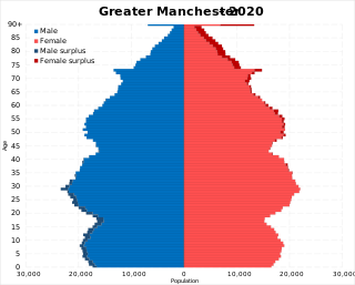
The demography of Greater Manchester is analysed by the Office for National Statistics and data is produced for each of its ten metropolitan boroughs, each of the Greater Manchester electoral wards, the NUTS3 statistical sub-regions, each of the Parliamentary constituencies in Greater Manchester, the 15 civil parishes in Greater Manchester, and for all of Greater Manchester as a whole; the latter of which had a population of 2,682,500 at the 2011 UK census. Additionally, data is produced for the Greater Manchester Urban Area. Statistical information is produced about the size and geographical breakdown of the population, the number of people entering and leaving country and the number of people in each demographic subgroup.

Stacksteads is a village between the towns of Bacup and Waterfoot within the Rossendale borough of Lancashire, England. The population of this Rossendale ward at the 2011 census was 3,789. Stacksteads includes a mountain bike trail called Lee Quarry which had originally been a working quarry.

Bradford, England is an ethnically and culturally diverse city. The City of Bradford metropolitan borough is the sixth most populous local authority district in the United Kingdom, and includes not only Bradford but also the towns and villages of Keighley, Shipley, Bingley, Ilkley, Haworth, Silsden, Queensbury, Thornton and Denholme.

The Lancaster/Morecambe Built-up area is an urban area which comprises the city of Lancaster and the towns of Morecambe and Heysham in Lancashire, England. The urban area covers an area which has a population of 97,150. The urban area includes the suburbs of both Lancaster and Morecambe. It has three subdivisions: Heysham, Lancaster and Morecambe. The built-up area and its subdivisions are entities defined algorithmically by the Office for National Statistics, which considers built-up land separated from another settlement by 200 metres (660 ft).

The Barnsley-Dearne Valley Built-up area is an urban area which extends from the town of Barnsley to Mexborough in South Yorkshire, England. The area takes in parts of the boroughs of Barnsley, Doncaster and Rotherham. The area includes villages and towns that lie in the Dearne and Rother Valleys. The area was recorded at having a population of 223,281.
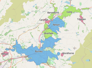
The Burnley Built-up area is an urban area or conurbation which extends from the town of Burnley to Padiham, Brierfield, Nelson, Barrowford and Colne in Lancashire, England. The area takes in parts of the boroughs of Burnley and Pendle, and also small parts of Hyndburn and Ribble Valley. It also includes a number of villages such as Blacko, Trawden and Worsthorne. In 2011 the area was recorded at having a population of 149,422. It is the third most populous urban area in Lancashire after Preston and Blackpool, with slightly more people than the urban areas of Cambridge or York.
The Rhyl/Prestatyn Built-up area is an urban area which extends from the coastal town of Rhyl to Prestatyn in Denbighshire, Wales. The area takes part of the county of Denbighshire. The area includes the villages of Meliden and Dyserth. The population was recorded at being 46,267.
The Norwich Built-up Area is an urban area which extends from the city of Norwich to Taverham, Horsham St Faith and Cringleford in Norfolk, England. The area takes in the district of the City of Norwich, and parts of Broadland and South Norfolk districts. The area was recorded at having a population of 213,166.
The Ipswich Built-up Area is a Built up Area, a statistical unit devised by the UK Office of National Statistics to organise data for an urban area which extends from the town of Ipswich to Kesgrave, Woodbridge, Bramford and Martlesham Heath in Suffolk, England. The area takes in the borough of Ipswich, parts of the East Suffolk and part of the Mid Suffolk. The area was recorded at having a population of 178,835.
