Admaston/Bromley

Last updated
Admaston/Bromley
Township of Admaston/Bromley
Admaston Bromley ON.jpg
Typical countryside near Douglas
Renfrew locator map 2021.svg
Red pog.svg
Admaston/Bromley
Canada Southern Ontario location map 2.png
Red pog.svg
Admaston/Bromley
Coordinates: 45°31′45″N76°53′49″W / 45.52917°N 76.89694°W / 45.52917; -76.89694 Coordinates: 45°31′45″N76°53′49″W / 45.52917°N 76.89694°W / 45.52917; -76.89694 [1]
Country Flag of Canada (Pantone).svg  Canada
Province Flag of Ontario.svg  Ontario
County Renfrew
FormedJanuary 1, 2000 (2000-01-01)
Government
  TypeTownship
  MayorMichael Donohue
   MP Cheryl Gallant (CPC)
   MPP John Yakabuski (OPC)
Area
[2]
  Land524.06 km2 (202.34 sq mi)
Population
 (2016) [2]
  Total2,935
  Density5.6/km2 (15/sq mi)
Time zone UTC-5 (EST)
  Summer (DST) UTC-4 (EDT)
Postal code
K0J
Area codes 613,343
Website www.admastonbromley.com

Admaston/Bromley is an incorporated township in Renfrew County, Eastern Ontario, Canada. [1] It was formed on January 1, 2000, when Admaston and Bromley Townships were amalgamated. It takes part of its name from Admaston, Staffordshire, a small English hamlet. [3]

Contents

Communities

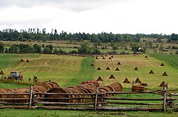
The township comprises the communities of Admaston, Balsam Hill, Belangers Corners, Bromley, Bulgers Corners, Connaught, Douglas, Ferguslea, Fremo Corners, Kellys Corner, Martins Corner, McDougall, Moores Lake, Mount St. Patrick, Northcote, Oakgrove, Osceola, Payne, Pine Valley, Renfrew Junction, Rosebank, Shamrock, and Wolftown.

The town of Douglas is the third of five chutes (waterfalls) along the Bonnechere River. The others being Castleford, Renfrew, Fourth Chute and Eganville.

Demographics

Admaston/Bromley
YearPop.±%
19912,752 [lower-alpha 1]     
1996 2,837 [lower-alpha 2] +3.1%
2001 2,824−0.5%
2006 2,716−3.8%
2011 2,844+4.7%
2016 2,935+3.2%
2016, [4] 2011 [5] , 2006 [6] , earlier [7]

In the 2021 Census of Population conducted by Statistics Canada, Admaston/Bromley had a population of 2,995 living in 1,136 of its 1,305 total private dwellings, a change of

Douglas Douglas ON.JPG
Douglas
Hamlet of Shamrock Shamrock ON.JPG
Hamlet of Shamrock

See also

Notes

  1. Population is the sum of Admaston Township: 1551 and Bromley Township: 1201
  2. Population is the sum of Admaston Township: 1648 and Bromley Township: 1189

Related Research Articles

The Nation, Ontario Municipality in Ontario, Canada

The Nation is a municipality in Eastern Ontario, located within Canada's National Capital Region, in the United Counties of Prescott and Russell. Formed in 1998, the municipality consists of the former Townships of Caledonia, Cambridge and South Plantagenet, as well as the Village of St. Isidore.

North Grenville Municipality in Ontario, Canada

North Grenville is a township in eastern Ontario, Canada, in the United Counties of Leeds and Grenville on the Rideau River. It is located just south of Ottawa in Canada's National Capital Region.

Alfred and Plantagenet Township in Ontario, Canada

Alfred and Plantagenet is a Franco-Ontarian township in eastern Ontario, Canada, in the United Counties of Prescott and Russell. Located approximately 70 km (43 mi) from downtown Ottawa at the confluence of the Ottawa River and the South Nation River.

Champlain, Ontario Township in Ontario, Canada

Champlain is a township in eastern Ontario, Canada, in the United Counties of Prescott and Russell on the Ottawa River. It was formed on January 1, 1998, through the amalgamation of West Hawkesbury Township, Longueuil Township, Town of Vankleek Hill, and the Village of L'Orignal.

Renfrew County County in Ontario, Canada

Renfrew County is a county in the Canadian province of Ontario. It stands on the west bank of the Ottawa River. There are 17 municipalities in the county.

Tay Valley, Ontario Township in Ontario, Canada

Tay Valley is a township in eastern Ontario, Canada, on the Tay River in the southwest corner of Lanark County, adjacent to the United Counties of Leeds and Grenville and Frontenac County. The township administrative offices are located in Glen Tay.

East Hawkesbury Township in Ontario, Canada

East Hawkesbury is a township in eastern Ontario, Canada, in the United Counties of Prescott and Russell. Situated on the Ottawa River, its eastern boundary is the border with the province of Quebec.

McNab/Braeside Township in Ontario, Canada

McNab/Braeside is a township in eastern Ontario, Canada, on the south shore of Chats Lake, straddling the lower Madawaska River in Renfrew County.

Horton, Ontario Township in Ontario, Canada

Horton is a township in eastern Ontario, Canada, at the confluence of the Bonnechere River and the Ottawa River in Renfrew County. The Town of Renfrew was originally part of Horton Township.

Renfrew, Ontario Town in Ontario, Canada

Renfrew is a town on the Bonnechere River in Renfrew County, Ontario, Canada. Located one hour west of Ottawa in Eastern Ontario, Renfrew is the fourth largest town in the county after Petawawa, Pembroke and Arnprior. The town is a small transportation hub connecting Highway 60 and Highway 132 with the Trans-Canada Highway. Renfrew is also known historically for its role in the formation of the National Hockey League. It lies about 5 kilometres from the Quebec border, about 10 kilometres by road. Renfrew makes most of Canada’s hockey tape.

Head, Clara and Maria Township in Ontario, Canada

Head, Clara and Maria, officially the United Townships of Head, Clara and Maria, is a municipality and incorporated township in Renfrew County in eastern Ontario, Canada, It is on the Ottawa River and on the northern edge of Algonquin Park.

Admaston is a small hamlet in Staffordshire, England just outside the town of Rugeley near to Abbots Bromley and Blithfield Hall.

Laurentian Valley Township municipality in Ontario, Canada

Laurentian Valley is a township municipality in Renfrew County in eastern Ontario, Canada. It borders on the Ottawa River, the city of Pembroke and the town of Petawawa.

Laurentian Hills Town in Ontario, Canada

Laurentian Hills is a municipality in Eastern Ontario, Canada, on the Ottawa River in Renfrew County. It surrounds Deep River on the Ontario side of the river. The town is home to the Nuclear Power Demonstration nuclear power plant. The prototype nuclear power plant was operational 1962-1987 and has since then been shutdown for over 30 yeas, waiting for permanent disposal of the radioactive nuclear components. The municipality was formed on January 1, 2000, when the United Townships of Rolph, Buchanan, Wylie and McKay and the Village of Chalk River were merged.

South Algonquin Township municipality in Ontario, Canada

South Algonquin is a township municipality in Nipissing District, Ontario, Canada. Located south of Algonquin Provincial Park, it is the sole populated portion of the district that lies south of the traditional dividing line between Northern Ontario and Southern Ontario and is closer connected to Renfrew County as opposed to the core portions of Nipissing District.

Killaloe, Hagarty and Richards Township in Ontario, Canada

Killaloe, Hagarty and Richards is an incorporated township in Renfrew County in eastern Ontario, Canada, created on July 1, 2000, as a result of an amalgamation of the Township of Hagarty and Richards with the Village of Killaloe.

Brudenell, Lyndoch and Raglan Township in Ontario, Canada

Brudenell, Lyndoch and Raglan is a township in Renfrew County, Ontario, Canada. It was formed on January 1, 1999, through the merger of Brudenell and Lyndoch Township with Raglan Township.

Bonnechere Valley Township municipality in Ontario, Canada

Bonnechere Valley is a township municipality in Renfrew County, Ontario, Canada. It had a population of 3,674 in the Canada 2016 Census. It was established in 2001 by amalgamation of the village of Eganville and the townships of Grattan, Sebastapol and South Algona.

North Algona Wilberforce Township municipality in Ontario, Canada

North Algona Wilberforce is a township municipality in Renfrew County, Ontario, Canada. It has a population of 2,873. The township was formed in 1999 when the North Algona and Wilberforce townships were amalgamated.

Greater Madawaska Township municipality in Ontario, Canada

Greater Madawaska is an incorporated township in Renfrew County in eastern Ontario, Canada, created on January 1, 2001, through the amalgamation of the Township of Bagot and Blythfield; the Township of Brougham; and the Township of Griffith and Matawatchan. As of 2011, it has a population of 2,518.

References

  1. 1 2 "Admaston/Bromley". Geographical Names Data Base . Natural Resources Canada . Retrieved 2012-10-06.
  2. 1 2 "Admaston/Bromley census profile". 2011 Census of Population . Statistics Canada. Retrieved 2012-02-09.
  3. The Citizen's District Staff of Correspondents (30 October 1937). "Origin of Place Names in District: Admaston". The Ottawa Evening Citizen. No. 115. Ottawa, Canada. p. 19. Retrieved 16 August 2015. Admaston in Renfrew county was named after a village in Staffordshire, England.
  4. "Census Profile, 2016 Census Admaston/Bromley, Township". Statistics Canada . Retrieved June 3, 2019.
  5. "2011 Community Profiles". 2011 Canadian Census . Statistics Canada. March 21, 2019.
  6. "2006 Community Profiles". 2006 Canadian Census . Statistics Canada. August 20, 2019.
  7. "2001 Community Profiles". 2001 Canadian Census . Statistics Canada. July 18, 2021.
  8. "Population and dwelling counts: Canada, provinces and territories, census divisions and census subdivisions (municipalities), Ontario". Statistics Canada. February 9, 2022. Retrieved April 2, 2022.