Adumo is a town in Chimbu Province, in the Highlands Region of Papua New Guinea.
Adumo is a town in Chimbu Province, in the Highlands Region of Papua New Guinea.

The Embraer ERJ family are regional jets designed and produced by the Brazilian aerospace company Embraer. The family includes the ERJ 135, ERJ 140, and ERJ 145, as well as the Legacy 600 business jet and the R-99 family of military aircraft.
The Dennistoun Glacier is a glacier, 50 nautical miles long, draining the northern slopes of Mount Black Prince, Mount Royalist and Mount Adam in the Admiralty Mountains of Victoria Land, Antarctica. It flows northwest between the Lyttelton Range and Dunedin Range, turning east on rounding the latter range to enter the sea south of Cape Scott.

The Leverett Glacier is about 50 nautical miles (90 km) long and 3 to 4 nautical miles wide, flowing from the Antarctic Plateau to the south end of the Ross Ice Shelf through the Queen Maud Mountains. It is an important part of the South Pole Traverse from McMurdo Station to the Admundson–Scott South Pole Station, providing a route for tractors to climb from the ice shelf through the Transantarctic Mountains to the polar plateau.
The Tapley Mountains is a range of mountains fronting on the eastern side of the Scott Glacier, extending eastward for 35 nautical miles between Leverett Glacier and Albanus Glacier in the Queen Maud Mountains of Antarctica.

The Molucca Sea is located in the western Pacific Ocean, around the vicinity of Indonesia, specifically bordered by the Indonesian Islands of Celebes (Sulawesi) to the west, Halmahera to the east, and the Sula Islands to the south. The Molucca Sea has a total surface area of 77,000 square miles. The Molucca Sea is rich in coral and has many diving sites due to the deepness of its waters. The deepness of the water explains the reasoning behind dividing the sea into three zones, which functions to transport water from the Pacific Ocean to the shallower seas surrounding it. The deepest hollow in the Molucca Sea is the 15,780-foot (4,810-meter) Batjan basin. This region is known for its periodic experiences of earthquakes, which stems from the sea itself being a micro plate, in which the Molucca Sea is being subducted in two opposite directions: one in the direction of the Eurasian Plate to the west and the other in the direction of the Philippine Sea Plate to the east.
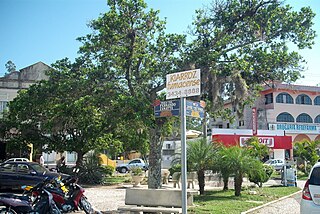
Morro da Fumaça is a Brazilian municipality in the state of Santa Catarina. Its population was estimated at 17,947 inhabitants in 2020. It has an area of 82.935 square kilometres (32.021 sq mi) and is located at an average elevation of 18 metres (59 ft).

Rolea B'ier is a district (srok) in the center of Kampong Chhnang province, in central Cambodia. The district capital is Rolea B'ier, a town located 5 kilometres south of the provincial capital of Kampong Chhnang. The district is surrounded by other Kampong Chhnang districts and in turn surrounds Kampong Chhnang district which includes the provincial capital. The Tonle Sap serves as the border of the district in the north east. The Kampong Chhnang Airport, built during the period of Democratic Kampuchea lies in Krang Leav commune.
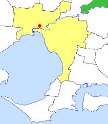
The Shire of Healesville was a local government area about 60 kilometres (37 mi) northeast of Melbourne, the state capital of Victoria, Australia. The shire covered an area of 466.20 square kilometres (180.0 sq mi), and existed from 1887 until 1994.

The Shire of Broadford was a local government area about 70 kilometres (43 mi) north of Melbourne, the state capital of Victoria, Australia. The shire covered an area of 576.3 square kilometres (222.5 sq mi), and existed from 1869 until 1994.

The Shire of Cobram was a local government area on the Murray River in the Goulburn Valley region, about 240 kilometres (149 mi) north of Melbourne, the state capital of Victoria, Australia. The shire covered an area of 322 square kilometres (124.3 sq mi), and existed from 1953 until 1994.
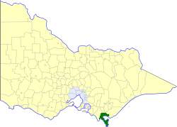
The Shire of South Gippsland was a local government area about 170 kilometres (106 mi) south-southeast of Melbourne, the state capital of Victoria, Australia. The shire covered an area of 1,432.26 square kilometres (553.0 sq mi), and existed from 1894 until 1994.

The Nymboida River, a perennial stream of the Clarence River catchment, is located in the Northern Rivers region of New South Wales, Australia.
Nickerson Ice Shelf, is an ice shelf about 35 nautical miles wide, lying north of Siemiatkowski Glacier and the western part of Ruppert Coast, Marie Byrd Land, Antarctica.

Williamsford, Tasmania is the location of a former mining community, south of Rosebery, Tasmania and on the western lower reaches of Mount Read.
The Phillips Mountains are a range of mountains on the north side of Balchen Glacier and Block Bay in the Ford Ranges, Marie Byrd Land, Antarctica.

NGC 5668 is a nearly face-on spiral galaxy, visual magnitude about 11.5, located about 81 million light years away in the constellation Virgo. It was discovered in 1786 by William Herschel. It is a member of the NGC 5638 Group of galaxies, itself one of the Virgo III Groups strung out to the east of the Virgo Supercluster of galaxies.
6°39′S145°12′E / 6.650°S 145.200°E
| | This Chimbu Province geography article is a stub. You can help Wikipedia by expanding it. |