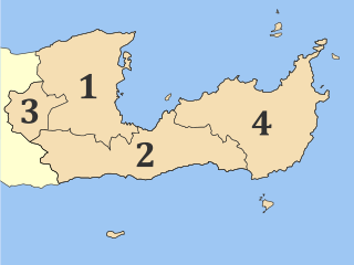
Lasithi is the easternmost regional unit on the island of Crete, to the east of Heraklion. Its capital is Agios Nikolaos, the other major towns being Ierapetra and Sitia. The mountains include the Dikti in the west and the Thrypti in the east. The Sea of Crete lies to the north and the Libyan Sea to the south.

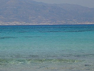
Myrtos is a coastal village in the west of the municipality of Ierapetra, in the Regional Unit of Lasithi on the Greek island of Crete. It is located 50 km (31 mi) from Agios Nikolaos and 15 km (9.3 mi) from Ierapetra, on the road to Viannos. A little to the west of the village is the iconic conical Kolektos mountain. Myrtos is situated on the Libyan Sea. The patron saint of the village is Saint Anthony. The population of the village in 2010 was approximately 600 people.

Ierapetra is a Greek city and municipality located on the southeast coast of Crete.
Koutsouras (Κουτσουράς) is a village in Lasithi regional unit, in Crete, Greece 22 kilometers east of Ierapetra. Its population is 818. It was the headquarters of the municipality of Makry Gialos and is the biggest village in the region. Key economic activities include agriculture and tourism. It has nice beaches and a golf course is due to be built over the next five years. The coast is rocky and there are beautiful pebble beaches with crystal clear waters. Today it is the seat of Makry Gialos municipal unit and part of Ierapetra municipality.


Gra Lygia is located approximately 4 km west of Ierapetra center. Its residents are called "GraLighiotes". They are occupied mainly in the agriculture sector; this is the main source of income for the residents and their income per capita is one of the highest in the region. The village is surrounded by greenhouses which demonstrates that the agriculture sector is modernized. There are many firms in related fields such as agriculture companies that co-operate with multinationals.

Thrypti is a mountain range in Lasithi in eastern Crete, Greece. It trends to the northeast from Ierapetra in the southwest in the direction of Sitia. However, it only goes half-way in that direction. The rest of the distance is completed by the distinct Ornon mountains, separated from the Thrypti by the Bebonas river valley, and the lower Western Siteia Foothills covering the space between the Ornon range and Sitia itself. The highest peak of Thrypti is Afentis, which is 1,476 m amsl. The three ranges constitute the West Sitia Mountains.
Schinokapsala is a community and a small village in Lasithi on Crete. It is situated 21 kilometers north-east from Ierapetra and 6 km from the sea. Since 2011 it belongs to the Ierapetra municipality.

Males is a historic village in the municipality of Ierapetra in Lasithi prefecture on Crete. It is situated 25 kilometers north-west of Ierapetra, 40 from Agios Nikolaos and 12 kilometers away from the sea. Together with nearby hamlets Hristos and Metaxohori Males until recently formed the Nea Mala municipality. It is built 550 meters above sea level, south east of Dikti mountain, in an area rich in vegetation. It is built where the ancient city of Mala was.
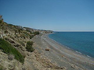
Ferma is a settlement in the municipality of Ierapetra on the island of Crete. It is situated at the coast, 11 kilometers east of Ierapetra.
Koutsounari is a settlement of 437 inhabitants on the island of Crete, along the slope of the Sitia Mountains. It is located 8 kilometers east of Ierapetra and 43 kilometers southeast of Agios Nikolaos. The village was established in the 1970s. Today it is best known for the nearby holiday destination of Long Beach.

Greece is a country in Southeastern Europe, on the Balkan Peninsula. It is bordered to the north by Albania, North Macedonia and Bulgaria; to the east by Turkey, and is surrounded to the east by the Aegean Sea, to the south by the Cretan and the Libyan seas, and to the west by the Ionian Sea which separates Greece from Italy.
Chrysi or Chrisi is an uninhabited Greek island approximately 15 kilometres south of Crete close to Ierapetra in the Libyan Sea. Approximately 700 metres east of the island is the island of Mikronisi. Administratively these islands fall within the Ierapetra municipality in Lasithi.
Stavrochori is an historic village of eastern Crete. It belonged to the former province of Sitia and later to the former Makry Gialos municipality. Today it is part of Ierapetra municipality. It is located in a wooded valley, 29 kilometers north east from Ierapetra and 35 kilometers southwest from Sitia. Once it was the most populous village of the region and the administrative center of the surrounding settlements. Since the last 30 years, the majority of its population has moved to the seaside settlement of Koutsouras, 7 kilometers to the south. Stavrochori is a traditional village with many sights. It is also the birthplace of Ioannis Papachatzakis or "Stravogiannios", a violinist, who lived and died in Ierapetra. He was one of the most important Cretan traditional organ players of the last century.

Livadi beach is located in Ferma, 10 kilometers east of Ierapetra, in Crete. Next to the beach are the most hotels.
Myrtos is a small village located about 15 km west of Ierapetra in Crete. The main beach at Myrtos has gray pebbles, crystal clear waters and is sheltered from the wind.
Koutsounari Long Beach is located 5 km east of the village Koutsounari near Ierapetra. Extends for 5 km so called Long beach. The development of the beach began after 1970 and it was mild. The beach is not organized, except for a small part of which has sun loungers, umbrellas and a canteen. The eastern part of the beach, located beneath known tavern and is also very organized. Along the rest of the beach, trees provide shade to visitors. All along, the beach has small pebbles in some places relatively shallow waters. Due to its length, the long beach is ideal for water sports.
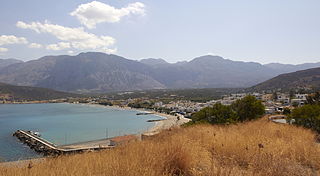
The beach Pachia Ammos, located 20 km east of Agios Nikolaos and about 10 km from Ierapetra, in front of the village Pachia Ammos in Crete.
Pacheia Ammos is a village in the municipality of Ierapetra on the island of Crete in Greece. It is located on the north coast of the island, 15 km to the north of the city of Ierapetra, at the fork in the road that leads to Heraklion in the west and Sitia in the east.
