This page is based on this
Wikipedia article Text is available under the
CC BY-SA 4.0 license; additional terms may apply.
Images, videos and audio are available under their respective licenses.

Lesbos Prefecture was one of the prefectures of Greece. It comprised three main islands: Lesbos itself, Lemnos, and the smaller island of Agios Efstratios. Its capital was the town of Mytilene, on Lesbos. In 2011 the prefecture was abolished and the territory was divided between the regional units of Lesbos and Lemnos.

The North Aegean is one of the thirteen administrative regions of Greece. It comprises the islands of the north-eastern Aegean Sea, called the North Aegean islands, except for Thasos and Samothrace, which belong to the Greek region of Eastern Macedonia and Thrace, and Imbros and Tenedos, which belong to Turkey.
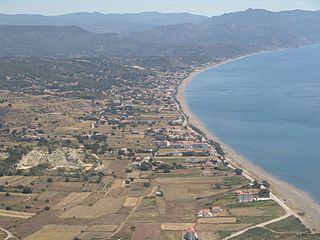
Vatera is an 8-kilometer long sandy beach in the southern part of Lesbos island. The name (Βατερά) comes from βάτα, in reference to prickly bushes that blocked the old mule-drive access.

Vrisa is a village in the southern part of Lesbos island approximately 50 km from Mytilene. The village is named after one of the two girls Agamemnon took from Lesbos during the ten-year Trojan War. Five kilometers south is the famous Vatera beach.
On June 12, 2017 Vrissa was severely damaged in an earthquake that struck approximately 12 km South of the town of Plomari. Most people could not return to their homes, rendering the village effectively a "ghost village".
Neochori may refer to the following places:
Megalochori may refer to the following places in Greece:
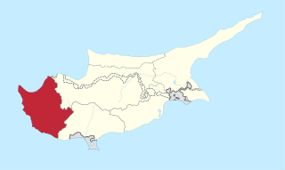
Pafos District is one of the six districts of Cyprus and it is situated in the western part of Cyprus. Its main town and capital is Pafos. The entire district is controlled by the internationally recognized government of Cyprus. There are four municipalities in Paphos District: Paphos, Yeroskipou, Peyia, and Polis Chrysochous.

Lesbos is an island located in the northeastern Aegean Sea. It has an area of 1,633 km2 (631 sq mi) with 320 kilometres of coastline, making it the third largest island in Greece. It is separated from Turkey by the narrow Mytilini Strait and in late Palaeolithic/Mesolithic times was joined to the Anatolian mainland before the end of the last glacial period.

Agios Efstratios or Saint Eustratius, colloquially Ai Stratis is a small Greek island in the northern Aegean Sea about 30 kilometres southwest of Lemnos and 80 kilometres northwest of Lesbos. The municipality has an area of 43.325 km2. Together with Lemnos and nearby islets it forms the regional unit of Lemnos, part of the Greek archipelagic region of the North Aegean.

Agios Nikolaos is a village located 120 kilometers south-east from Thessaloniki on the Chalkidiki peninsula in Macedonia, Greece.

The petrified forest of Lesbos is a petrified forest on Lesbos in Greece.
Neochori is a village on the island of Chios, Greece. It is part of the municipality Agios Minas, and located approximately 9 kilometers from the capital of the island, Chios (town), also known locally as Chora. There are medieval manuscripts that refer to the village but no sign of the Middle Ages was preserved. The inhabitants are mainly farmers. The main church is devoted to Virgin Mary and it is an example of the local architecture of the 19th century.
Agios Isidoros may refer to several places in Greece:

Lemnos is one of the regional units of Greece. It is part of the region of North Aegean. The regional unit covers the islands of Lemnos, Agios Efstratios and a few smaller, uninhabited islands, in the Aegean Sea.
Palaiochori is a village on the island of Lesbos, North Aegean, Greece. It is situated on a mountainside 12 km NW from the town of Plomari. The church of the village was built in 1864 and is dedicated to the Annunciation of the Virgin Mary. The beach of Melinda is located 3 km south of the village.

The 2017 Lesbos earthquake occurred at 12:28:39 UTC on 12 June. The earthquake's epicentre was 5 km south of Plomari on the Greek island of Lesbos off the Aegean coast of Turkey. It had a magnitude of 6.3 on the moment magnitude scale and a maximum perceived intensity of IX (Violent) on the Mercalli intensity scale. Extensive damage was caused on parts of southern Lesbos, where there was one fatality and 10 people were injured. The earthquake was also felt in Turkey but no significant damage or injuries were reported.
Therma was a town of ancient Lesbos.


