The Ucayali River arises about 110 km (68 mi) north of Lake Titicaca, in the Arequipa region of Peru. The Amazon River takes its name close to Nauta city, at the confluence of the Marañón and Ucayali rivers. The Ucayali becomes a major tributary of the Amazon River. Navigation was blocked by lengthy sections of rapids. The city of Pucallpa is located on the banks of the Ucayali.

Huánuco is a department in central Peru. It is bordered by the La Libertad, San Martín, Loreto and Ucayali regions in the north, the Ucayali Region in the east, the Pasco Region in the south and the Lima and Ancash regions in the west. Its capital is the city Huánuco.

Pucallpa is a city in eastern Peru located on the banks of the Ucayali River, a major tributary of the Amazon River. It is the capital of the Ucayali region, the Coronel Portillo Province and the Calleria District.

The Huallaga River is a tributary of the Marañón River, part of the Amazon Basin. Old names for this river include Guallaga and Rio de los Motilones. The Huallaga is born on the slopes of the Andes in central Peru and joins the Marañón before the latter reaches the Ucayali River to form the Amazon. Its main affluents are the Monzón, Mayo, Biabo, Abiseo and Tocache rivers. Coca is grown in most of those valleys, which are also exposed to periodic floods.

The Washington Supreme Court is the highest court in the judiciary of the US state of Washington. The Court is composed of a Chief Justice and eight Justices. Members of the Court are elected to six-year terms. Justices must retire at the end of the calendar year in which they reach the age of 75, per the Washington State Constitution.

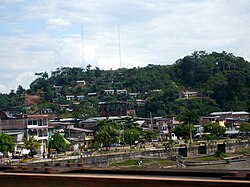
Contamana is a town in the Loreto Region in northeastern Peru. It is the capital of both Ucayali Province and Contamana District and has an urban population of about 15,036. It has one airport.

The Puerto Inca Province is the largest of eleven provinces of the Huánuco Region in Peru. The capital of this province is the city of Puerto Inca.
Cashibo, Cacataibo, Cashibo-Cacataibo, Managua, or Hagueti is an indigenous language of Peru in the region of the Aguaytía, San Alejandro, and Súngaro rivers. It belongs to the Panoan language family.

The Leoncio Prado Province is one of eleven provinces of the Huánuco Region in Peru. The capital of this province is the city of Tingo María.

The Ucayali Province is one of the seven provinces in the Loreto Region of Peru. It was created on October 13, 1900, by president Eduardo López de Romaña. Its territory is mostly flat except for the Ganso Azul mountain range in its eastern part.
Purús District is the only district of the Purús Province located in the Ucayali Region in Peru. The Purus River runs through it.

Piney Point, is an unincorporated community and census-designated place in St. Mary's County, Maryland, United States. It is known for the Paul Hall Center for Maritime Training and Education, houses along the beach, a lighthouse, and a museum. The Piney Point post office also serves St. George Island, which is connected to Piney Point by a short bridge.

Smith is a hamlet in northern Alberta, Canada within the Municipal District of Lesser Slave River No. 124. It is located on Highway 2A, approximately 182 kilometres (113 mi) northwest of Edmonton, at the confluence of the Lesser Slave River and the Athabasca River.

Nõmmeveski is a village in Kuusalu Parish, Harju County in northern Estonia, on the territory of Lahemaa National Park. It lies on the Valgejõgi River, where a 1.2 m (4 ft) waterfall is situated.

Lake Yarinacocha is a lake in Peru located in the Ucayali Region, Coronel Portillo Province, Yarinacocha District. It is situated at a height of about 149 metres (489 ft), about 15.45 km long and 0.82 km at its widest point. Lake Yarinacocha lies west of the Ucayali River and northwest of Pucallpa.

Defensor San Alejandro is a Peruvian football club, playing in the city of Aguaytía, Padre Abad, Ucayali, Peru.

The Napo moist forests (NT0142) is an ecoregion in the western Amazon rainforest of Colombia, Ecuador and Peru.

The Ucayali moist forests (NT0174) is an ecoregion in the western Amazon rainforest of Peru.