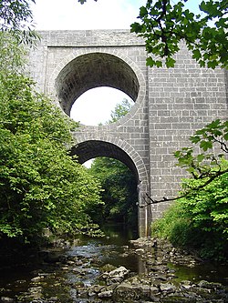
The Aille River in County Clare in Ireland rises on the slopes of Slieve Elva in the Burren. It flows through the spa town of Lisdoonvarna and on to Doolin, where it reaches the sea not far from the Cliffs of Moher. Flowing through Lisdoonvarna it gives rise to sulphur, iron, and magnesium wells there. In summer, the river often disappears into the limestone cave system in Doolin.
Coordinates: 53°00′31″N9°23′26″W / 53.0087°N 9.39058°W
County Clare is a county in Ireland, in the Mid-West Region and the province of Munster, bordered on the west by the Atlantic Ocean. Clare County Council is the local authority. The county had a population of 118,817 at the 2016 census. The county town and largest settlement is Ennis.
The Burren is a karst/glaciokarst landscape in County Clare, Ireland, which measures between 250 square kilometres (97 sq mi) and 560 square kilometres (220 sq mi), within the circle made by the villages of Tubber, Corofin, Kilfenora, Lisdoonvarna, Ballyvaughan, all in County Clare, and Kinvara in County Galway.
Lisdoonvarna is a spa town of 739 people in County Clare in Ireland. The town is famous for its music and festivals. Although the music festival was discontinued in the 1980s, Lisdoonvarna still hosts its annual matchmaking festival each September.
Doolin is a coastal village in County Clare, Ireland, on the Atlantic coast. It is southwest of the spa town of Lisdoonvarna. It is a noted centre of traditional Irish music, which is played nightly in its pubs, making it a popular tourist destination. There are numerous nearby archaeological sites, many dating to the Iron Age and earlier. Doonagore Castle and Ballinalacken Castle are also in the area. The area was officially classified as part of the West Clare Gaeltacht prior to the 1950s, and maintains a connection with Irish-speaking areas - including via its maritime connection with the Aran Islands.
Doonagore Castle is a round 16th-century tower house with a small walled enclosure located about 1 km south of the coastal village of Doolin in County Clare, Ireland. Its name may be derived from Dún na Gabhair, meaning "the fort of the rounded hills" or the "fort of the goats". Doonagore Castle is at present a private holiday home, inaccessible to the public.
Kilshanny is a village and a civil parish in west County Clare, Ireland.
The Totley Brook is a stream in Sheffield, South Yorkshire, England. It rises on a millstone grit ridge some 7 miles (11 km) to the south-west of the centre of Sheffield. Over its course it drops from 740 feet (230 m) to 430 feet (130 m) near its junction with the Old Hay Brook close to Baslow Road. The streams form the River Sheaf once they have joined.
Doolin Cave is a limestone cave near Doolin in County Clare, Ireland, on the western edge of The Burren. The name is the anglicised version of the Irish name Poll an Eidhneáin, which is said to translate into "Ivy Cliff Cave". The cave attracted some controversy due to its development and marketing as a show cave in the early 21st century. It is now open to the public, branded as Doolin Cave.
The River Dunsop is a river in the Forest of Bowland in Northern England. It flows into the River Hodder at Dunsop Bridge.
The River Swincombe is a tributary of the West Dart River that flows through Dartmoor national park in Devon, south-west England. It rises south-east of Princetown, and flows 2 km south-east to Foxtor Mires, where it turns north-east to meet the West Dart near Hexworthy. The first 2 km are known as the Strane River. Some maps show that the source starts north of Nakers Hill and heads north west to the east of Foxtor Mires where it meets the Strane River which is its own river.
The Castletown River is a river which flows through the town of Dundalk, County Louth, Ireland. It rises near Newtownhamilton, County Armagh, Northern Ireland, and is known as the Creggan River in its upper reaches. Its two main tributaries are the Kilcurry and Falmore rivers and it enters the Irish Sea at Dundalk Bay.
The Lower Saxon Hills are one of the 73 natural regions in Germany defined by the Federal Agency for Nature Conservation (BfN). Geographically it covers roughly the same area as the Weser Uplands in its wider sense.
Ballaghline is a townland on the western seaboard of County Clare, Ireland. It is 6 kilometres east of Lisdoonvarna, on the outskirts of Doolin.
The Burren and Cliffs of Moher Geopark is an internationally designated area of geological interest in The Burren region of County Clare, Ireland. It is the third Geopark to be designated in Ireland, and is recognised at both European and global levels.
Killilagh or Killeilagh is a civil parish in County Clare, Ireland. It contains the village of Doolin.
Lena Doolin Mason was an American Methodist preacher and poet.
The R459 road is a regional road in Ireland, located in Doolin, County Clare.
Wild Honey Inn, located in Lisdoonvarna, County Clare, is Ireland's only Michelin star pub with 14 rooms and has a four-star guesthouse rating. It was awarded a Michelin star in 2017.
The Spectacle Bridge is a bridge built in May 1816 over the Aille River in County Clare, Ireland.
Lisdoonvarna/Kilshanny parish is a parish in County Clare and part of the Kilfenora Deanery of the Roman Catholic Diocese of Galway, Kilmacduagh and Kilfenora. The parishes Lisdoonvarna and Kilshanny amalgamated in the 1980s.