
The bald eagle is a bird of prey found in North America. A sea eagle, it has two known subspecies and forms a species pair with the white-tailed eagle. Its range includes most of Canada and Alaska, all of the contiguous United States, and northern Mexico. It is found near large bodies of open water with an abundant food supply and old-growth trees for nesting.

Hunza, also known as Kanjut, was a princely state in a subsidiary alliance with British India from 1892 to August 1947, for three months was unaligned, and then from November 1947 until 1974 was a princely state of Pakistan. Hunza covered territory now forming the northernmost part of Gilgit-Baltistan, Pakistan.

Gilgit is the capital city of Gilgit-Baltistan, region of Pakistan. The city is located in a broad valley near the confluence of the Gilgit River and Hunza River. Gilgit is a major tourist destination in Pakistan, and serves as a hub for trekking and mountaineering expeditions in the Karakoram Range.
The Karakoram Highway is a 1,300-kilometre (810 mi) national highway which extends from Hasan Abdal in the Punjab province of Pakistan to the Khunjerab Pass in Gilgit-Baltistan, where it crosses into China and becomes China National Highway 314. The highway connects the Pakistani provinces of Punjab and Khyber Pakhtunkhwa plus Gilgit-Baltistan with China's Xinjiang Uyghur Autonomous Region. The highway is a popular tourist attraction and is one of the highest paved roads in the world, passing through the Karakoram mountain range, at 36°51′00″N75°25′40″E at maximum elevation of 4,714 metres (15,466 ft) near Khunjerab pass. Due to its high elevation and the difficult conditions in which it was constructed, it is often referred to as the Eighth Wonder of the World. The highway is also a part of the Asian Highway AH4.

The Gilgit Agency was a system of administration established by British Indian Empire over the subsidiary states of princely state of Jammu and Kashmir at its northern periphery, mainly with the objective of strengthening these territories against Russian encroachment.

Chitral is the capital of the Chitral District, situated on the Chitral River in northern Khyber Pakhtunkhwa, Pakistan. Chitral also served as the capital of the princely state of Chitral until 1947.

Baltit Fort is a fort in the Hunza valley, near the town of Karimabad, in the Gilgit-Baltistan region of northern Pakistan. Founded in the 8th CE, it has been on the UNESCO World Heritage Tentative list since 2004.
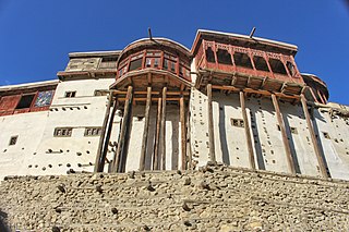
Karimabad, formerly known as Baltit, is the capital of Hunza District, in the Gilgit-Baltistan province of Pakistan. The Guardian ranked it as one of the five "Best Tourist Sites" in Pakistan.

The Burusho or Brusho, also known as the Hunza people or Botraj, live in Hunza, Nagar, Chitral, and in valleys of Gilgit–Baltistan in northern Pakistan, as well as in Jammu and Kashmir, India. Their language, Burushaski, has been classified as a language isolate. Although their origins are unknown, it is likely that the Burusho people "were indigenous to northwestern India and were pushed into their present homeland by the movements of the Indo-Aryans who migrated to the subcontinent in 1800 B.C.

Chilas is a small town located in the Gilgit-Baltistan, Pakistan on the river Indus. It is part of the Silk Road connected by the Karakoram Highway and N-90 National Highway, which link it to Islamabad and Peshawar in the southwest, via Hazara and Malakand Divisions of Khyber Pakhtunkhwa. In the north, Chilas is connected to the Chinese cities of Tashkurgan and Kashgar in Xinjiang, via Gilgit, Aliabad, Sust, and the Khunjerab Pass.

PTDC or Pakistan Tourism Development Corporation is an organization of the Government of Pakistan. PTDC is governed by the Board of Directors and provides transportation to various areas and owns and runs several motels across the country. It was incorporated on March 30, 1970.

Nagar Valley also known as Nagar Khas is a valley near Hunza Valley in the Nagar District of Gilgit Baltistan, Pakistan. The valley is about 15 kilometres (9.3 mi) from Hunza Valley and 105 kilometres (65 mi) from the city of Gilgit. The valley is home to many high mountain peaks including Rakaposhi, Diran Peak, Golden Peak and Rush Peak. The main villages in the valley include Sikandarabad, Chalt, Minapin, Gulmit and Hoper. Burushaski and Shina languages are spoken in the valley. Rush Lake, the highest alpine lake of Pakistan and the 27th highest lake in the world also lies in this valley.

Gilgit-Baltistan, formerly known as the Northern Areas, is a region administered by Pakistan as an administrative territory, and constituting the northern portion of the larger Kashmir region which has been the subject of a dispute between India and Pakistan since 1947, and between India and China from somewhat later. It is the northernmost territory administered by Pakistan. It borders Azad Kashmir to the south, the province of Khyber Pakhtunkhwa to the west, the Wakhan Corridor of Afghanistan to the north, the Xinjiang region of China, to the east and northeast, and the Indian-administered union territories Jammu and Kashmir and Ladakh to the southeast.

The Eagles Nest Wilderness is a U.S. Wilderness Area located in the Gore Range near Vail, Copper Mountain, Frisco, Silverthorne, and Heeney, in Summit and Eagle Counties Colorado. Eagles Nest Wilderness falls within the jurisdiction of Dillon Ranger District and Holy Cross Ranger District, White River National Forest. The 135,114-acre (546.79 km2) wilderness with 180 miles (290 km) of trails was established in 1976. In 2010, additional lands were proposed for wilderness protection under the Hidden Gems proposal, affecting Elliot Ridge, Tenmile, and Lower Piney areas of Summit and Eagle Counties.

Attabad Lake is a lake in Gojal Valley, Hunza, Gilgit Baltistan, an administrative region of Pakistan. The lake was created in January 2010 as a result of the Attabad Disaster. Attabad Lake has become one of the biggest tourist attractions in Gilgit-Baltistan offering activities like boating, jet skiing, fishing and other recreational activities.
The major ethnic groups of Pakistan include Jatts, Punjabis, Pashtuns, Sindhis, Saraikis, Muhajirs, Baloch, Paharis,Hindkowans, Chitralis and other smaller groups. Smaller ethnic groups found throughout the nation include Kashmiris, Kalash, Siddi, Burusho, Wakhis, Khowar, Hazara, Shina, Kalyu and Baltis.

Gilgit Baltistan is an administrative territory of Pakistan, that borders the province of Khyber Pakhtunkhwa to the west, Azad Kashmir to the southwest, Wakhan Corridor of Afghanistan to the northwest, the Xinjiang Uyghur Autonomous Region of China to the north, and the Indian state of Jammu and Kashmir to the south and southeast.

The princely states of Pakistan were former princely states of the British Indian Empire which acceded to the new Dominion of Pakistan between 1947 and 1948, following the Partition of (British) India and its independence.
