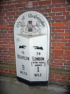
The mile is an English unit of length of linear measure equal to 5,280 feet, or 1,760 yards, and standardised as exactly 1,609.344 metres by international agreement in 1959.

Miles Dewey Davis III was an American jazz trumpeter, bandleader, and composer. He is among the most influential and acclaimed figures in the history of jazz and 20th century music. Davis adopted a variety of musical directions in a five-decade career that kept him at the forefront of many major stylistic developments in jazz.

A nautical mile is a unit of measurement used in both air and marine navigation, and for the definition of territorial waters. Historically, it was defined as one minute of a degree of latitude. Today it is defined as exactly 1852 metres. The derived unit of speed is the knot, one nautical mile per hour.

Franklin County is a nongovernmental county located in the U.S. state of Massachusetts. As of the 2010 census, the population was 71,372, which makes it the least-populous county on the Massachusetts mainland, and the third-least populous county in the state. Its traditional county seat and most populous city is Greenfield. Its largest town by area is New Salem.

Lee County is a county of the U.S. state of Alabama. As of the 2010 census the population was 140,247. The county seat is Opelika, and the largest city is Auburn. The county is named for General Robert E. Lee (1807–1870), who served as General in Chief of the Armies of the Confederate States in 1865. Lee County comprises the Auburn-Opelika, AL Metropolitan Statistical Area, which is included in the Columbus-Auburn-Opelika, GA-AL Combined Statistical Area.

Colusa is the county seat of Colusa County, California. The population was 5,971 at the 2010 census, up from 5,402 at the 2000 census. Colusi originates from the local Coru Native American tribe, who in the 1840s lived on the opposite side of the Sacramento River.

Stanford is a census-designated place (CDP) in Santa Clara County, California, United States and is the home of Stanford University. The population was 13,809 at the 2010 census, with a daily population of 35,000.
Kalispell is a city in, and the county seat of Flathead County, Montana, United States. The 2015 Census estimates put Kalispell's population at 22,052. The Kalispell Micropolitan Statistical Area has a population of 93,068 and it is the largest city and commercial center of northwest Montana. The name Kalispell is a Salish word meaning "flat land above the lake". Kalispell is also the gateway to Glacier National Park.
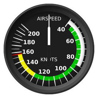
The knot is a unit of speed equal to one nautical mile per hour, exactly 1.852 km/h. The ISO standard symbol for the knot is kn. The same symbol is preferred by the Institute of Electrical and Electronics Engineers (IEEE); kt is also common, especially in aviation where it is the form recommended by the International Civil Aviation Organization (ICAO). The knot is a non-SI unit. Worldwide, the knot is used in meteorology, and in maritime and air navigation—for example, a vessel travelling at 1 knot along a meridian travels approximately one minute of geographic latitude in one hour.
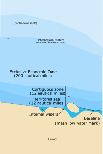
The term territorial waters is sometimes used informally to refer to any area of water over which a state has jurisdiction, including internal waters, the territorial sea, the contiguous zone, the exclusive economic zone and potentially the continental shelf. In a narrower sense, the term is used as a synonym for the territorial sea.

On May 18, 1980, a major volcanic eruption occurred at Mount St. Helens, a volcano located in Skamania County, in the U.S. state of Washington. The eruption was the most significant volcanic eruption to occur in the contiguous 48 U.S. states since the much smaller 1915 eruption of Lassen Peak in California. It has often been declared as the most disastrous volcanic eruption in U.S. history. The eruption was preceded by a two-month series of earthquakes and steam-venting episodes, caused by an injection of magma at shallow depth below the volcano that created a large bulge and a fracture system on the mountain's north slope.

The local-express lane system is an arrangement of carriageways within a major highway where long distance traffic can use lanes with fewer interchanges compared to local traffic which use 'local' or 'collector' lanes that have access to all interchanges. This can also be called collector–distributor lanes within a single interchange. Where highway ramps between express and local/collector lanes cross over one another this is commonly known as braided ramps. One of the longest examples is Ontario Highway 401 between Etobicoke and Pickering in Canada.

8 Mile: Music from and Inspired by the Motion Picture is the official soundtrack to the 2002 movie of the same name. The album, performed by various artists, was released under Shady Records. It spawned the hit single "Lose Yourself" by Eminem, who also stars in the semi-autobiographical movie. The album also spawned a follow up soundtrack, More Music from 8 Mile, consisting of songs that appear in the film and were released as singles during the film's time setting of 1995. One of the songs was performed by 2Pac, who would be the subject of a documentary with a soundtrack produced by Eminem, who also produced a posthumous album by 2Pac. The album also features four songs by the Wu-Tang Clan and its members, and two songs by Mobb Deep, who eventually signed to G-Unit Records. Both albums were also made available in censored versions, removing most of the strong language and sexual and violent content.

Las Vegas Motor Speedway, located in Clark County, Nevada in Las Vegas, Nevada about 15 miles northeast of the Las Vegas Strip, is a 1,200-acre (490 ha) complex of multiple tracks for motorsports racing. The complex is owned by Speedway Motorsports, Inc., which is headquartered in Charlotte, North Carolina.

8 Mile is a 2002 American biographical drama film written by Scott Silver, directed by Curtis Hanson, and starring Eminem, Mekhi Phifer, Brittany Murphy, Michael Shannon, and Kim Basinger. The film is based on the real Jimmy Smith Jr., who was shot shortly after the events of the film, and follows white rapper B-Rabbit (Eminem) and his attempt to launch a career in a genre dominated by African-Americans. The title is derived from 8 Mile Road, the highway between the predominantly black city of Detroit and Wayne County and the predominantly white Oakland County and Macomb County suburbs. It was filmed mostly on location. 8 Mile was a critical and commercial success. Eminem won the Academy Award for Best Original Song for "Lose Yourself".
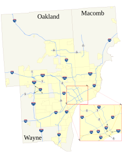
The roads and freeways in metropolitan Detroit comprise the main thoroughfares in the region. The freeways consist of an advanced network of interconnecting freeways which include Interstate highways. The Metro Detroit region's extensive toll-free freeway system, together with its status as a major port city, provide advantages to its location as a global business center. There are no toll roads in Michigan.

Miles City is a city in and the county seat of Custer County, Montana, United States. The population was 8,410 at the 2010 census.

The Whelen All-American Series is a points championship for NASCAR sanctioned local short track motor racing around the United States and Canada.
In the 30 years of NASCAR sanctioning weekly racing for a national championship, the tracks have been split, initially by geographical proximity of the tracks for purposes of developing regional champions, then randomly among four divisions and currently by states that have tracks participating.

Miles Gonzalo Morales is a fictional comic book superhero appearing in publications by the American publisher Marvel Comics, and one of the characters known as Spider-Man. The character was created in 2011 by writer Brian Michael Bendis and artist Sara Pichelli, with input by Marvel's then-editor-in-chief Axel Alonso.