
The Kaveri is an Indian river flowing through the states of Karnataka and Tamil Nadu. The Kaveri river rises at Talakaveri in the Brahmagiri range in the Western Ghats, Kodagu district of the state of Karnataka, at an elevation of 1,341 m above mean sea level and flows for about 800 km before its outfall into the Bay of Bengal. It reaches sea in Poompuhar in mayiladuthurai district. It is the third largest river – after Godavari and Krishna – in South India and the largest in the State of Tamil Nadu, which, on its course, bisects the state into North and South. The Kaveri is sacred river to the people of South India and is worshipped as the Goddess Kaveriamma. The Kaveri is also one of the seven holy rivers of India. Kaveri river is useful for agriculture in Tamilnadu.

Nagapattinam is a town in the Indian state of Tamil Nadu and the administrative headquarters of Nagapattinam District. The town came to prominence during the period of Medieval Cholas and served as their important port for commerce and east-bound naval expeditions. The Chudamani Vihara in Nagapattinam constructed by the Srivijayan king Sri Mara Vijayattungavarman of the Sailendra dynasty with the help of Rajaraja Chola I was an important Buddhist structure in those times. Nagapattinam was settled by the Portuguese and, later, the Dutch under whom it served as the capital of Dutch Coromandel from 1660 to 1781. In November 1781, the town was conquered by the British East India Company. It served as the capital of Tanjore district from 1799 to 1845 under Madras Presidency of the British. It continued to be a part of Thanjavur district in Independent India. In 1991, it was made the headquarters of the newly created Nagapattinam District. Nagapattinam is administered by a Selection-grade municipality covering an area of 17.92 km2 (6.92 sq mi) and had a population of 102,905 as of 2011.

Bangalore Urban district, officially known as Bengaluru Urban district, is a district of the Indian state of Karnataka. It is surrounded by the Bangalore Rural district on the east and north, the Ramanagara district on the west and the Krishnagiri district of Tamil Nadu on the south. Bangalore Urban district came into being in 1986, with the partition of the erstwhile Bangalore district into Bangalore Urban and Bangalore Rural districts. Bangalore Urban has five taluks: Bangalore North (Bengaluru), Bangalore South (Kengeri), Bangalore East, Yelahanka and Anekal. The city of Bangalore is situated in the Bangalore Urban district. The district has 17 hoblies, 668 villages, 9 municipal corporations, and five talukas. Electronics City is situated in Anekal Taluka.

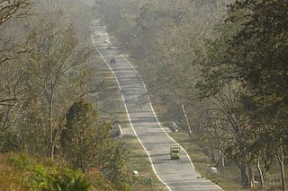
National Highway 4 was a major National Highway before National Highway renumbering in Western and Southern India. NH 4 linked four of the 10 most populous Indian cities - Mumbai, Pune, Bangalore, and Chennai. NH 4 was 1,235 km (767 mi) in length and passed through the states of Maharashtra, Karnataka and Tamil Nadu.

Nagapattinam district is one of the 38 districts of Tamil Nadu state in southern India. Nagapattinam district was carved out by bifurcating the erstwhile composite Thanjavur district on 19 October 1991. The town of Nagapattinam is the district headquarters. As of 2011, the district had a population of 1,616,450 with a sex-ratio of 1,025 females for every 1,000 males. Until Mayiladuthurai district was created out of it on 24 March 2020, Nagapattinam was the only discontiguous district in Tamil Nadu.
Bayaluseeme or Bayalu Seeme is the area lying to the east of Malenadu, a region of Karnataka state in India. The area is largely open plain, with few hillocks. It includes the districts of Bangalore, Bagalkot, Bijapur, Chitradurga, Davanagere, Dharwad, Gadag, Hassan, Haveri, Mandya, Mysore, Tumkur.
Kuruvai, also known as "short-term" in Tamil, are the crops grown in cauvery Delta of Tamil Nadu state in India. The crops that are grown in this delta are mostly paddy and the health of these crops and the eventual livelihood of these farmers are extremely dependent on abundant flow of water on the Cauvery river.
Gundlupet is a municipal town situated in the Chamarajanagar district of Karnataka, India. It is also known as "The flower pot of Karnataka". It is situated 60 km away from NH 766 and approximately 200 km from the state administrative capital, Bangalore. Gundlupet is the last town in Karnataka on the National Highway 766 which goes through Mysore, Ooty, Wayanad, and Calicut. It is situated very close to the Tamil Nadu and Kerala state borders. NH 181 begins from Gundlupet and ends in Nagapattinam in Tamil Nadu via Ooty and Coimbatore.

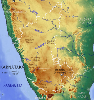
The Indian State of Karnataka is located 11°30' North and 18°30' North latitudes and 74° East and 78°30' East longitude. .It is situated on a tableland where the Western and Eastern Ghat ranges converge into the complex, in the western part of the Deccan Peninsular region of India. The State is bounded by Maharashtra and Goa States in the north and northwest; by the Arabian Sea in the west; by Kerala and Tamil Nadu States in the south and by the States of Andhra Pradesh and Telangana in the east. Karnataka extends to about 750 km from north to south and about 400 km from east to west.
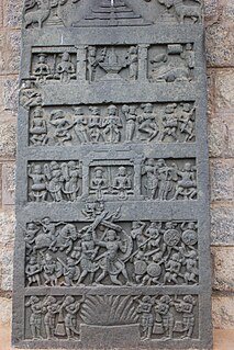
A hero stone is a memorial commemorating the honorable death of a hero in battle. Erected between the 6th century BC and the 18th century AD, hero stones are found all over India. They often carry inscriptions displaying a variety of adornments, including bas relief panels, frieze, and figures on carved stone. Usually they are in the form of a stone monument and may have an inscription at the bottom with a narrative of the battle. The Earliest and oldest of such memorial Hero stones is found in the Indian state of Tamil Nadu is more than 2400 years old that is 4th Century BC. According to the historian Upinder Singh, the largest concentration of such memorial stones is found in the Indian state of Karnataka. About two thousand six hundred and fifty hero stones, the earliest in Karnataka is dated to the 5th century AD. The custom of erecting memorial stones dates back to the Iron Age though a vast majority were erected between the 4th century BC to 13th centuries AD.

Akkur is a village in the southern state of Karnataka, India. It is located in the Ramanagara taluk of Ramanagara district - 562159.
The 1991 Anti-Tamil violence in Karnataka refers to incidents of mob violence targeting Tamils in state of Karnataka in India. The incidents took place in Southern Karnataka on 12–13 December 1991, mainly in the cities of Bangalore and Mysore. The attacks originated in the demonstrations organised against the orders of the Cauvery Water Tribunal appointed by the Government of India. The violence terrified the Tamil populace of Southern Karnataka forcing hundreds of thousands to flee in a matter of weeks. The official statistics given by the Government of Karnataka was that sixteen people had been killed in the police firing during protest but individual sources give higher numbers.

This article gives a list of the territories of the dioceses of the Catholic Church in India.
The 2008 Karnataka-Tamil Nadu alcohol poisonings was an incident in the southern Indian states of Karnataka and Tamil Nadu in May 2008 in which 180 people reportedly died after consuming illicit liquor. This incident is considered to be the worst methanol poisoning in the country since at least 2000.
Sathanur may refer to several places in India:
Aremallapur is a village in the southern state of Karnataka, India. It is located in the Ranebennur taluk of Haveri district in Karnataka.