
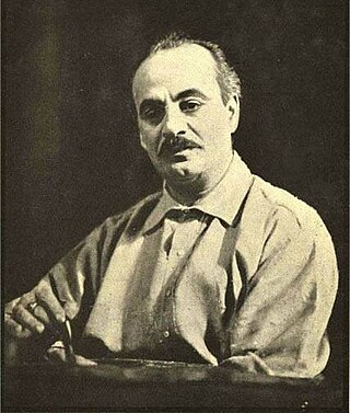
Gibran Khalil Gibran, usually referred to in English as Kahlil Gibran, was a Lebanese-American writer, poet and visual artist; he was also considered a philosopher, although he himself rejected the title. He is best known as the author of The Prophet, which was first published in the United States in 1923 and has since become one of the best-selling books of all time, having been translated into more than 100 languages.
Mazanderani, also spelled Mazandarani, or Tabarian (طبریان) may refer to:
Hindawi or Hindavi can refer to:
Khalil, Khelil, or Khaleel may refer to:
Qamar is an Arabic name used both as a masculine and feminine, which means "moon", "natural satellite", or "moonlight".
Ahmed Khalil Sebait Mubarak Al-Junaibi is an Emirati footballer who plays as a forward for Al Bataeh and United Arab Emirates national team.

Khalil Ahmad Saharanpuri was an Indian Islamic scholar of the Deobandi movement. He authored Badhl Al-Majhud Fi Hall Abi Dawud, an 18-volume commentary on the hadith collection Sunan Abi Dawud. He was also a Sufi shaykh of the Chishti order, being a disciple and successor of Rashid Ahmad Gangohi.
Mughrabi, Mugrabi, Mograby, Mograbi, or Moghrabi is a surname and place name derived from "Maghreb" – meaning "West" in Arabic, and usually referring to North Africa or specifically to Morocco, i.e., the westernmost part of the Arab and Muslim world. It exists among both Muslims and Jews originating from this region.
Khalili is a common Arabic-based surname, meaning "originating from Al-Khalil also known as Hebron". It is composed of root word Khalil plus the Arabic suffix "i" meaning "from" or "of". Khalili is also commonly used in Persian, Afghani and other Muslim surnames.
Khalil or Khaleel means friend and is a common male first name in the Middle East, the Caucasus, the Balkans, North Africa, West Africa, East Africa, Central Asia and among Muslims in South Asia and as such is also a common surname. It is also used amongst Turkic peoples of Russia and African Americans. Abraham is given the title Khalīl-ullah in Islam. The female counterpart of this name is Khalila or Khaleela.
Gebran is a well-known given name and family name in Arabic. It is also transliterated as Gibran, Jebran, Jibran, Joubran, Jubran, Goubran and Gubran. It might also appear with an additional "e" at the end, like in Gebrane, Gibrane etc.
Al-Ashraf, either from al-ashraf or al-ashrāf, may refer to:
Khalil Ibrahim (1957–2011) was the founder of the Justice and Equality Movement, Sudan.
Mohammad Khalil may refer to:
Ahmed Khalil is an Emirati association football player.
This page is based on this
Wikipedia article Text is available under the
CC BY-SA 4.0 license; additional terms may apply.
Images, videos and audio are available under their respective licenses.