Petroleum geology is the study of origin, occurrence, movement, accumulation, and exploration of hydrocarbon fuels. It refers to the specific set of geological disciplines that are applied to the search for hydrocarbons.

A turbidite is the geologic deposit of a turbidity current, which is a type of amalgamation of fluidal and sediment gravity flow responsible for distributing vast amounts of clastic sediment into the deep ocean.

The Acadian orogeny is a long-lasting mountain building event which began in the Middle Devonian, reaching a climax in the early Late Devonian. It was active for approximately 50 million years, beginning roughly around 375 million years ago, with deformational, plutonic, and metamorphic events extending into the Early Mississippian. The Acadian orogeny is the third of the four orogenies that formed the Appalachian orogen and subsequent basin. The preceding orogenies consisted of the Potomac and Taconic orogeny, which followed a rift/drift stage in the Late Neoproterozoic. The Acadian orogeny involved the collision of a series of Avalonian continental fragments with the Laurasian continent. Geographically, the Acadian orogeny extended from the Canadian Maritime provinces migrating in a southwesterly direction toward Alabama. However, the Northern Appalachian region, from New England northeastward into Gaspé region of Canada, was the most greatly affected region by the collision.

The Taconic orogeny was a mountain building period that ended 440 million years ago and affected most of modern-day New England. A great mountain chain formed from eastern Canada down through what is now the Piedmont of the East coast of the United States. As the mountain chain eroded in the Silurian and Devonian periods, sediments from the mountain chain spread throughout the present-day Appalachians and midcontinental North America.
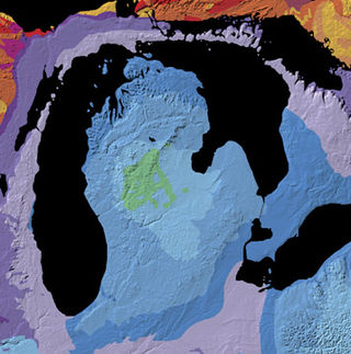
The Michigan Basin is a geologic basin centered on the Lower Peninsula of the U.S. state of Michigan. The feature is represented by a nearly circular pattern of geologic sedimentary strata in the area with a nearly uniform structural dip toward the center of the peninsula.

The Sirte Basin is a late Mesozoic and Cenozoic triple junction continental rift along northern Africa that was initiated during the late Jurassic Period. It borders a relatively stable Paleozoic craton and cratonic sag basins along its southern margins. The province extends offshore into the Mediterranean Sea, with the northern boundary drawn at the 2,000 meter (m) bathymetric contour. It borders in the north on the Gulf of Sidra and extends south into northern Chad.

The Ordovician Reedsville Formation is a mapped surficial bedrock unit in Pennsylvania, Maryland, Virginia, West Virginia, and Tennessee, that extends into the subsurface of Ohio. This rock is a slope-former adjacent to the prominent ridge-forming Bald Eagle sandstone unit in the Appalachian Mountains. It is often abbreviated Or on geologic maps.

The Clinton Group is a mapped unit of sedimentary rock found throughout eastern North America. The interval was first defined by the geologist Lardner Vanuxem, who derived the name from the village of Clinton in Oneida County, New York where several well exposed outcrops of these strata can be found. The Clinton Group and its lateral equivalents extend throughout much of the Appalachian Foreland Basin, a major structural and depositional province extending from New York to Alabama. The term has been employed in Kentucky, Maryland, Michigan, New York, Ohio, Pennsylvania, Tennessee, Virginia, and West Virginia, though in many of these areas the same interval is referred to as the Rose Hill, Rockwood, or Red Mountain Formations. Historically the term "Clinton" has also been assigned to several lower Silurian stratigraphic units in Ohio and Kentucky which are now known to be significantly older than the Clinton Group as it was originally defined. Many parts of this succession are richly fossiliferous, making the Clinton Group an important record of marine life during the early Silurian. Several economically valuable rock-types are found within this interval, though it is perhaps best known as a significant source of iron ore

The Marcellus Formation or the Marcellus Shale is a Middle Devonian age unit of sedimentary rock found in eastern North America. Named for a distinctive outcrop near the village of Marcellus, New York, in the United States, it extends throughout much of the Appalachian Basin.
In petroleum geology, source rock is rock which has generated hydrocarbons or which could generate hydrocarbons. Source rocks are one of the necessary elements of a working petroleum system. They are organic-rich sediments that may have been deposited in a variety of environments including deep water marine, lacustrine and deltaic. Oil shale can be regarded as an organic-rich but immature source rock from which little or no oil has been generated and expelled. Subsurface source rock mapping methodologies make it possible to identify likely zones of petroleum occurrence in sedimentary basins as well as shale gas plays.
The Beaverhill Lake Group is a geologic unit of Middle Devonian to Late Devonian age in the Western Canada Sedimentary Basin that is present in the southwestern Northwest Territories, northeastern British Columbia and Alberta. It was named by the geological staff of Imperial Oil in 1950 for Beaverhill Lake, Alberta, based on the core from a well that they had drilled southeast of the lake, near Ryley, Alberta.

The Oklahoma City Oil Field is one of the world's giant petroleum fields and is located in Oklahoma City, Oklahoma in the United States of America. The field was opened just south of the city limits on December 4, 1928, and first entered Oklahoma City limits on May 27, 1930.
The Bowen Formation is an Ordovician-age geological formation in the Appalachian region of the eastern United States. It occupies a thin stratigraphic range between the Wardell and Witten formations in some areas of southwest Virginia and northeast Tennessee. It is particularly well-exposed in Tazewell County, Virginia. Unlike its encompassing strata, the Bowen Formation is mostly calcareous sandstone and mudrock rather than limestone. The thicker upper part of the formation is composed of layered red mudrock which is replete with mudcracks. The thinner lower part, which is not always preserved, is a coarser unit of dark grey stratified sandstone which weathers to a rusty-brown color. Fossils are rare, restricted to stromatolites and Tetradium fibratum.
The Vinini Formation is a marine, deep-water, sedimentary deposit of Ordovician to Early Silurian age in Nevada, U.S.A. It is notable for its highly varied, mainly siliceous composition, its mineral deposits, and controversies surrounding both its depositional environment and structural history. The formation was named by Merriam and Anderson for an occurrence along Vinini Creek in the Roberts Mountains of central Nevada and that name is now used extensively in the State.
The Mansfield Natural Gas Field is located west of Mansfield, Ohio, within the Appalachian foreland basin. The field is 1.5 miles (2.4 km) long by 1.4 miles (2.3 km) wide and is in a general oval shape, stretching northward. This field, although small, is an analog for many of the natural gas fields that occur within the Appalachian Basin. It was first discovered by the Pan American Petroleum and Transport Company in the early 1930s. It is part of the Utica – Lower Paleozoic system, which is estimated to make up 15 to 20 percent of the total hydrocarbon abundance of the Appalachian Basin.
The geology of Ohio formed beginning more than one billion years ago in the Proterozoic eon of the Precambrian. The igneous and metamorphic crystalline basement rock is poorly understood except through deep boreholes and does not outcrop at the surface. The basement rock is divided between the Grenville Province and Superior Province. When the Grenville Province crust collided with Proto-North America, it launched the Grenville orogeny, a major mountain building event. The Grenville mountains eroded, filling in rift basins and Ohio was flooded and periodically exposed as dry land throughout the Paleozoic. In addition to marine carbonates such as limestone and dolomite, large deposits of shale and sandstone formed as subsequent mountain building events such as the Taconic orogeny and Acadian orogeny led to additional sediment deposition. Ohio transitioned to dryland conditions in the Pennsylvanian, forming large coal swamps and the region has been dryland ever since. Until the Pleistocene glaciations erased these features, the landscape was cut with deep stream valleys, which scoured away hundreds of meters of rock leaving little trace of geologic history in the Mesozoic and Cenozoic.

Cindy A. Yeilding is an American geologist from Houston, Texas. Yeilding is Senior Vice President of British Petroleum, America. She was formerly Vice President of exploration technology and assurance, and has held various other positions at BP in oil and gas, exploration of the Gulf of Mexico and geoscience.
The Bertie Group or Bertie Limestone, also referred to as the Bertie Dolomite and the Bertie Formation, is an upper Silurian geologic group and Lagerstätte in southern Ontario, Canada, and western New York State, United States. Details of the type locality and of stratigraphic nomenclature for this unit as used by the U.S. Geological Survey are available on-line at the National Geologic Map Database. The formation comprises dolomites, limestones and shales and reaches a thickness of 495 feet (151 m) in the subsurface, while in outcrop the group can be 60 feet (18 m) thick.

Randi Martinsen is an American geologist and senior lecturer in the Department of Geology and Geophysics at the University of Wyoming.
The Cayugan Series contains a number of carbonate, shale and evaporite formations of the upper Silurian System of sedimentary strata in eastern North America. It was formed during a period of marine transgression, and is near the end of the placid shallow marine environments of the Cambrian through Ordovician periods. The end of the Taconic orogeny marks the beginning of the Cayugan. A number of changes were taking place as the Iapetus Ocean was slowly shrinking. The north end of the sea had already closed. At the end of the Silurian and of the Cayugan Series, the Iapetus Ocean had entirely closed, leaving behind the Iapetus Suture. A result of being closed at one end was that fluctuations in sea level allowed for large parts of the Appalachian and Michigan basins to form large evaporite deposits. All of these deposits are found with in the Salina Group. While the Salina covers an area from New York to Illinois south into Kentucky and Tennessee, the evaporites are primarily found in western New York, western and central Pennsylvania, eastern Ohio and north western West Virginia. As well as in the Michigan Basin.