Brooklyn is the most populous borough of New York City, with an estimated 2,648,771 residents in 2017. Named after the Dutch village of Breukelen, it borders the borough of Queens at the western end of Long Island. Brooklyn has several bridge and tunnel connections to the borough of Manhattan across the East River, and the Verrazzano-Narrows Bridge connects it with Staten Island. Since 1896, Brooklyn has been coterminous with Kings County, the most populous county in the U.S. state of New York and the second-most densely populated county in the United States, after New York County.

Muswell Hill is a suburban district of north London. It is mainly in the London Borough of Haringey with a small part in the London Borough of Barnet. It is between Highgate, Hampstead Garden Suburb, East Finchley and Crouch End. It has many streets with Edwardian architecture.

Wood Green is a suburban district of North London, England, in the London Borough of Haringey. The London Plan identifies it as one of the metropolitan centres in Greater London.

Grover is a town in Cleveland County, North Carolina, United States. The population was 708 at the 2010 census.

Beeston is a town in Nottinghamshire, England, 3.4 miles (5.5 km) southwest of Nottingham city centre.
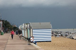
Felixstowe is a seaside town in Suffolk, England. At the 2011 Census, it had a population of 23,689. The Port of Felixstowe is the largest container port in the United Kingdom.

Hunters Hill is a suburb on the Lower North Shore and Northern Suburbs of Sydney, in the state of New South Wales, Australia. Hunters Hill is located nine kilometres north-west of the Sydney central business district and is the administrative centre for the local government area of the Municipality of Hunter's Hill.

Hyde Park is an inner-city area of north-west Leeds, West Yorkshire, England, situated between the University of Leeds and Headingley.

Grove Park is a district and electoral ward in south east London, England within the London Borough of Lewisham. It is located north east of Bromley and south west of Eltham, with Catford to the West, Hither Green and Lee Green to the North.
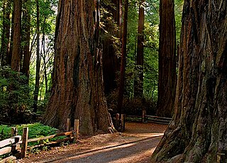
Henry Cowell Redwoods State Park is a state park of California, USA, preserving mainly forest and riparian areas in the watershed of the San Lorenzo River, including a grove of old-growth coast redwood. It is located in Santa Cruz County, primarily in the area between the cities of Santa Cruz and Scotts Valley, near the community of Felton and the University of California at Santa Cruz. The park includes a non-contiguous extension in the Fall Creek area north of Felton. The 4,623-acre (1,871 ha) park was established in 1954.

Richview is a neighbourhood in the city of Toronto, Ontario, Canada. It is located in the area of Etobicoke. It is bounded on the west by Highway 401 and on the north by the highway and by Dixon Road, Royal York Road on the east, and Eglinton Avenue West along the south. It encompasses the former post office of "Richview" which was merged into the then-borough of Etobicoke.
Thurnby Lodge is an estate in eastern Leicester, England. Roughly, it consists of the area inside the city boundary which is north of the Uppingham Road, east of the A563 outer ringroad, and south of the Scraptoft Lane. Since the core area around Thurncourt Road is a council estate with an average reputation, many, particular those around the western and southern fringe, would disassociate their area from Thurnby Lodge.
New Dorp Beach is along the shore of the neighborhood of New Dorp, on the south shore of Staten Island, one of the five boroughs of New York City. It is between Midland Beach and Oakwood Beach.

Christchurch Park is a 70-acre (280,000 m2) area of rolling lawns, wooded areas, and delicately created arboreta in central Ipswich, Suffolk, England. It contains Christchurch Mansion which holds a public museum and art gallery. The park opened as the town's first public park in 1895.

Edward Byles Cowell, was a noted translator of Persian poetry and the first professor of Sanskrit at Cambridge University.
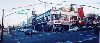
Kings Highway is a broad avenue that curves about southern part of the Borough of Brooklyn in New York City. Its west end is at Bay Parkway and 78th Street. East of Ocean Avenue, the street is largely residential. It tracks eastward, then northeast, then north through Brooklyn and reaches East 98th Street in central Brooklyn. At that point, it flows into Howard Avenue to provide seamless access to Eastern Parkway, another major road in Brooklyn with side medians and service roads.

Holywells Park is a 67-acre (270,000 m2) public park in Ipswich, England situated between Nacton Road and Cliff Lane, near to Ipswich dock.

Tipton Green is the central area of Tipton, a town in the West Midlands of England. It was heavily developed for heavy industry and housing during the 19th century, as Tipton was one of the most significant towns during the Industrial Revolution. Tipton Green is one of three electoral wards covering Tipton for Sandwell Metropolitan Borough Council. The population of this Sandwell ward taken at the 2011 census was 12,834. It is represented by three Labour councillors.

Warstock is a district within the city of Birmingham, UK, in the southern-most suburbs roughly 1 km east of the A435 and within the ward of Highter's Heath. The area lies within the B14 postcode and is contiguous with Yardley Wood to the north-east, Solihull Lodge to the south-east and Highter's Heath to the south-west. Kings Heath lies to the north-west.

Braunstone Park & Rowley Fields is an electoral ward and administrative division of the city of Leicester, England. It comprises the western Leicester suburbs of Braunstone Frith, Braunstone Park and Rowley Fields.